Page 1 of 2
Map Creation
Posted: Fri Jan 03, 2025 12:03 pm
by benpark
I'm somewhat comfortable with using QGiS, and see that program has a large role in creating maps for ABII. I've read through the AB tutorial a few times, and I'm ready to proceed with some experimentation. A few questions:
-Is there a reason to use DEMs from Earth Explorer, rather than the QGiS Plugin options that can supply the desired resolution? I use 30m map resolution with QGiS plugin DEMs from whatever source is best, currently.
-Is there a key to the map colors used in ABII? It isn't listed in the map making tutorial.
-What category keywords are most used in QuickOSM when culling things like roads/rivers/buildings for the ABII maps? I use this page for reference, but it this is also a vast amount of unneeded info-
https://wiki.openstreetmap.org/wiki/Map_features
It would also be great to get a dedicated modding and mapping section opened up here.
Thanks very much. I always appreciate a solidly fun historical wargame that can be tinkered with.
Re: Map Creation
Posted: Mon Jan 06, 2025 1:54 pm
by benpark
Period maps are needed for some regions depicted, but the heights haven't changed. I expect I'll start on something that actually gets loaded in the engine, and is less intense off the bat. Discrete parts of something like this gets a head start for what the map that lets the game engine know what underlying terrain is. Slowly figuring this all out, but getting...somewhere.
Re: Map Creation
Posted: Mon Jan 06, 2025 2:06 pm
by benpark
QGiS 3D view:

- Screenshot 2025-01-06 090338 - Copy.jpg (503.33 KiB) Viewed 895 times
Re: Map Creation
Posted: Mon Jan 06, 2025 5:52 pm
by Veitikka
About the terrain map colors I can say that the terrain_palette.png is in the game's docs folder.
The other questions will need to be answered by our map designer. I think he uses Earth Explorer for height maps because it's more accurate.
Re: Map Creation
Posted: Thu Jan 09, 2025 4:51 pm
by benpark
I have a map loaded in. The underlying terrain is black when I start in the map editor portion of the program. I don't see any documentation for that. Any help on the basics of that would be great.
I made a set of swatches for the Terrain file from the manual. They did't seem to be the right colors, so I need to redo those. My example on the left, one from the game on the right.
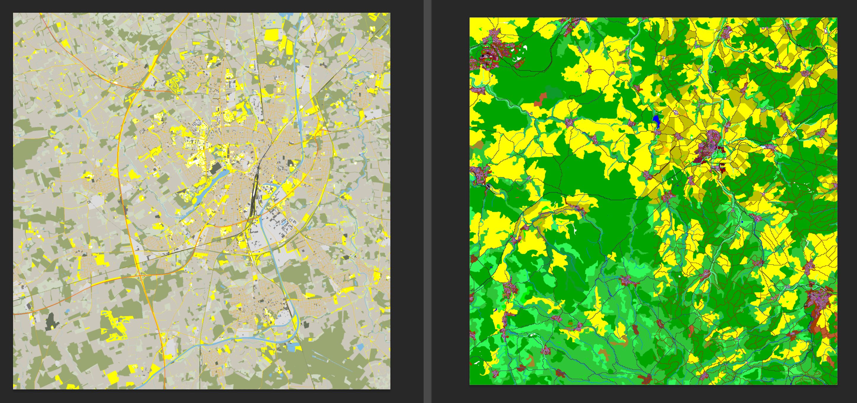
- Capture.JPG (711.97 KiB) Viewed 775 times
Re: Map Creation
Posted: Thu Jan 09, 2025 4:55 pm
by benpark
This is the map area from the Preview (Munster):
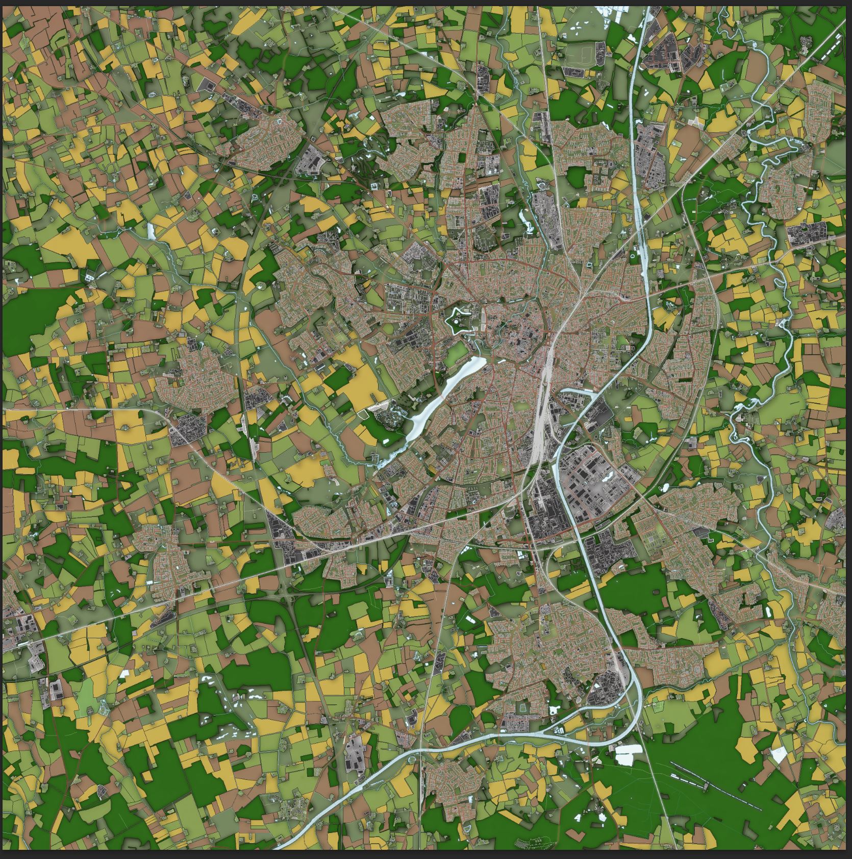
- Capture - Copy.JPG (772.84 KiB) Viewed 773 times
Re: Map Creation
Posted: Fri Jan 10, 2025 1:47 am
by Veitikka
benpark wrote: ↑Thu Jan 09, 2025 4:51 pm
I have a map loaded in. The underlying terrain is black when I start in the map editor portion of the program. I don't see any documentation for that. Any help on the basics of that would be great.
Your preview image is probably too large so it fails to load. The image can be any size when you work on the map (if it works for you), but for maximum compatibility in the final product I recommend no larger than 2048x2048 pixels. 4096x4096 can be ok.
Re: Map Creation
Posted: Wed Jan 15, 2025 12:33 pm
by johnny2008
I am also following map making tutorial to create maps. After successfully creating the height.bmp map, I encountered an issue while trying to create the terrain map. Using data from QuickOSM in QGIS, I couldn't generate a large number of buildings in map . I’d like to ask how the author creates the buildings in the terrain map. Where can I get mass and accurate building data?
Re: Map Creation
Posted: Wed Jan 15, 2025 6:10 pm
by benpark
I've grabbed anything I needed (roads, water features, buildings, etc) from here:
https://download.geofabrik.de/
You may then drag and drop the needed elements into your layers in QGIS. I have been making a PNG for each feature individually, then tracing them in. I don't think that the QGIS export (even at some thin line setting) will yield very usable and linked road networks. I use the line tool in Photoshop (set to 1 pixel), and hold SHIFT to get 45/90/135 degree angles. I also have 3 different Preview files to keep track of the underlying terrain.
I started with a Photoshop file with these layers. I think they are : Main roads (paved), secondary roads, residential roads, dirt roads, forest deciduous, forest coniferous, streams, water (impassable). I do that mainly in Photoshop, and check the map in the game and only fix a few details. I'm starting populated places, and I find the underlying Google map and a period map (1944 publication for a 1945 setting map) for where the houses and larger structures go. That will be somewhat abstracted given the tools, and I'll probably mainly be in the in-game editor for that, and all detail work.
This is a time-consuming process, but the tools in the editor have been great to use (after mapping Combat Mission maps for years in that editor, anyway). If I could do it again, I'd start with a 512x512 map., but now I've started and there's no going back.
Re: Map Creation
Posted: Thu Jan 16, 2025 1:14 am
by johnny2008
Thank you for your response. I would like to know how to load the data from
https://download.geofabrik.de/ (which is in PBF format) into QGIS. Previously, I tried using QuickOSM to open these PBF files, but it didn’t work. I’m not sure if it’s because the data files are too large or for some other reason. My computer has 32GB of RAM, so it shouldn’t be due to insufficient memory, right?
Re: Map Creation
Posted: Thu Jan 16, 2025 1:48 pm
by benpark
Keep in mind, I've taught myself all of this in a week of one or two-hour blocks, so I'm no expert on QGIS or this editor. Everything seems good to this stage (15% done on a working map), so I'll try to answer-
Most areas have SHP download options at the lowest region, which you need to click down to. Have an idea prior of where the map is. The map in the right corner of Geofabrik has a map that helps you to know if you are covered in that ZIP.
Be sure you are selecting down to the specific region you are looking for, and then you will see the option for SHP download. They are listed as having the suffix "SHP.ZIP", generally.
Once you download those and unzip 'em they can dragged into your QGIS layers. I don't pull all of them in, but any roads, water/waterways, woods, landuse are a definite. Buildings as well, but I'm doing those using the underlay map, mainly.
If you are trying to download all of "Europe" or "France", that option not going to show. It is a lot of data. I clip the area from the SHP files, and get rid of the rest so that my PNG exports are only the area desired for your map (clip to the heightmap, that's the easiest).
There are a lot of good QGIS tutorials on YouTube. I've been learning that way, mainly.
Re: Map Creation
Posted: Thu Jan 23, 2025 9:58 pm
by BletchleyGeek
benpark wrote: ↑Wed Jan 15, 2025 6:10 pm
This is a time-consuming process, but the tools in the editor have been great to use (after mapping Combat Mission maps for years in that editor, anyway). If I could do it again, I'd start with a 512x512 map., but now I've started and there's no going back.
That's quite a ringing endorsement. Whoever programmed those tools should be happy to hear this feedback.
I'm looking forward to seeing your maps, Ben. Your work elevates games.
Re: Map Creation
Posted: Fri Jan 24, 2025 11:36 am
by benpark
Thank you, that is really great to hear. I always appreciate your learned observations and expertise over on the other Matrix/Slitherine company, also appreciated here in these CM Hiatus Times.
Still plugging away on this map. I needed to learn how to add new 3D units (done, except for some weight issues on the guns), and am back to maps now. I have a plan where I'd like to tie it all together with a new, edited database with a scenario or two, a few new units, and the map.
Re: Map Creation
Posted: Fri Jan 24, 2025 1:26 pm
by benpark
Outside of Muncheberg, an old horse runs.
It will be interesting to see if I can mimic the early IR apparatus impact in the data.
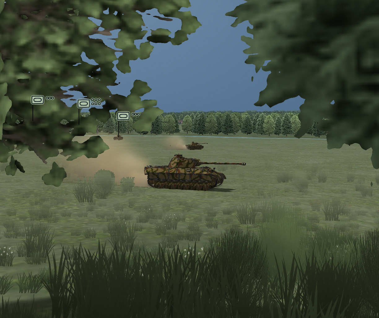
- armoredbrigade2.jpg (341.84 KiB) Viewed 535 times
Re: Map Creation
Posted: Fri Jan 24, 2025 8:30 pm
by MGK4167
Ben (or anyone else),
I would really appreciate a link to the Map Making guide that you are using. I can't seem to find the old ones from Armored Brigade. Any hints for how to update for Armored Brigade II would be also appreciated.
Thanks
Michael
Re: Map Creation
Posted: Fri Jan 24, 2025 8:59 pm
by benpark
The thread is here (with the PDF linked in the first post):
https://www.matrixgames.com/forums/view ... 0&t=331973
It was very helpful. I'd say that the QGIS side of things (which the PDF covers pretty well) is less important than I thought it would be. You could use it to grab the height-map, then use a correctly-scaled source map, since the in-game editor can use that with variable opacity. The rest (done in the in-game editor) is tracing and drawing. The tools in the editor are great, once you get them down.
I'd also start with a 512x512 map. I have the equivalent of that done (1/4) on my 1024x1024 map, and that has been a number of days of solid work when I can grab the time. It's great to be able to spend time on details, and the bigger maps will take that much longer.
Re: Map Creation
Posted: Fri Jan 24, 2025 10:46 pm
by MGK4167
Thank you very much for the quick reply. Exactly what I was after!
Re: Map Creation
Posted: Sun Jan 26, 2025 9:10 pm
by benpark
I'll be moving anything more about my learning process on the first map the maps and mods thread, but I'll post a few pictures now that I'm 1/4 done with the first test. The map has a lot of good rolling hills in the lower fourth that I've been spending my time in. Even that needs a little more time. I'm looking forward to a few new building and terrain types, at some point. You can still do quite a bit with what's there.
Re: Map Creation
Posted: Sun Jan 26, 2025 9:16 pm
by majgentob
benpark wrote: ↑Fri Jan 24, 2025 1:26 pm
Outside of Muncheberg, an old horse runs.
It will be interesting to see if I can mimic the early IR apparatus impact in the data.
armoredbrigade2.jpg
SWEET! Looks great.
Re: Map Creation
Posted: Fri Jan 31, 2025 9:06 am
by BletchleyGeek
benpark wrote: ↑Fri Jan 24, 2025 1:26 pm
Outside of Muncheberg, an old horse runs.
It will be interesting to see if I can mimic the early IR apparatus impact in the data.
armoredbrigade2.jpg
The Internet may have taken notice of this rift in the fabric of time. FWIW I loved shooting down B-17s with F-4s in Chuck Yeager's Air Combat... wouldn't mind seeing some Panther on Abrams action (or perhaps the other way around?).
Those map work screenshots are sweet! Looking fwd to play them sometime soon.