Page 7 of 10
RE: MWiF Map Review - India & Burma
Posted: Sun Jul 20, 2008 1:00 am
by Norman42
ORIGINAL: Froonp
I say your drawing is not that bad.
What do others think ?
I like Ian's map changes.
I would also add in the change to those 2 mountain hexes closest to the Tigris (change to Desert or Clear), and change the 4 hexes in between the Tigris and Euphrates Rivers to Clear.
RE: MWiF Map Review - India & Burma
Posted: Sun Jul 20, 2008 1:58 am
by paulderynck
ORIGINAL: Plain Ian
Regarding Iraq if we are going to use the map picture to get a better representation of the country then I think we also have to adjust its other borders. If we use the rivers Euphrates and Tigris to guage things then I think we would need to move the borders as below?

This one looks perfect to me. (Seems to me I've been seeing various maps of Iraq in the media now for about 15 years, and this one fits the burned-in image best.)
RE: MWiF Map Review - India & Burma
Posted: Sun Jul 20, 2008 6:05 am
by Froonp
ORIGINAL: paulderynck
This one looks perfect to me. (Seems to me I've been seeing various maps of Iraq in the media now for about 15 years, and this one fits the burned-in image best.)
Based on all your suggestions, it would look like this :

RE: MWiF Map Review - India & Burma
Posted: Sun Jul 20, 2008 6:23 am
by Froonp
ORIGINAL: Froonp
ORIGINAL: paulderynck
This one looks perfect to me. (Seems to me I've been seeing various maps of Iraq in the media now for about 15 years, and this one fits the burned-in image best.)
Based on all your suggestions, it would look like this :
I would not give the hex 2 hexes West of the lake to Syria. I woud leave it Iraqi (The lake looks to be about in the middle of the east-west width of Iraq).
RE: MWiF Map Review - India & Burma
Posted: Sun Jul 20, 2008 7:09 am
by Shannon V. OKeets
ORIGINAL: Froonp
ORIGINAL: paulderynck
This one looks perfect to me. (Seems to me I've been seeing various maps of Iraq in the media now for about 15 years, and this one fits the burned-in image best.)
Based on all your suggestions, it would look like this :
The alpine hexes would need to be removed too since they require mountains on both sides.
RE: MWiF Map Review - India & Burma
Posted: Sun Jul 20, 2008 7:18 am
by Froonp
ORIGINAL: Froonp
ORIGINAL: Froonp
ORIGINAL: paulderynck
This one looks perfect to me. (Seems to me I've been seeing various maps of Iraq in the media now for about 15 years, and this one fits the burned-in image best.)
Based on all your suggestions, it would look like this :
I would not give the hex 2 hexes West of the lake to Syria. I woud leave it Iraqi (The lake looks to be about in the middle of the east-west width of Iraq).
I also looked at the big picture of the Middle East, with those modifications in mind, and it looks good. I think I'm gonna do these Iraq / Kuwait modifications to the borders and terrain.
ORIGINAL: Shannon V. OKeets
The alpine hexes would need to be removed too since they require mountains on both sides.
Yes.
RE: MWiF Map Review - India & Burma
Posted: Sun Jul 20, 2008 10:25 am
by ahlner
Here is another suggestion for the Iraq-Kuwaiti border which I think resembles the real border as much as possible. Just two hex changes compared to the latest map (marked with dotted lines). I would also propose two hex changes to the Trans-Jordan eastern border on Saudi-Arabia and Iraq. Trans-Jordan is in my opinion depicted a bit large compared wtih the real map borders.

RE: MWiF Map Review - India & Burma
Posted: Sun Jul 20, 2008 12:34 pm
by Froonp
ORIGINAL: ahlner
Here is another suggestion for the Iraq-Kuwaiti border which I think resembles the real border as much as possible. Just two hex changes compared to the latest map (marked with dotted lines). I would also propose two hex changes to the Trans-Jordan eastern border on Saudi-Arabia and Iraq. Trans-Jordan is in my opinion depicted a bit large compared wtih the real map borders.
This is a variation of Plain Ian's proposal ? It looks like it is.
RE: MWiF Map Review - India & Burma
Posted: Sun Jul 20, 2008 12:41 pm
by Froonp
ORIGINAL: ahlner
Here is another suggestion for the Iraq-Kuwaiti border which I think resembles the real border as much as possible. Just two hex changes compared to the latest map (marked with dotted lines). I would also propose two hex changes to the Trans-Jordan eastern border on Saudi-Arabia and Iraq. Trans-Jordan is in my opinion depicted a bit large compared wtih the real map borders.
I think your variation to Trans-Jordan eastern and south eastern border is not better, as we can see on this 1942 map of the Middle East. The eastern border (with Iraq) looks like a straight line more or less NW-SE slope, and the previsous depiction is better IMO. The SE border with Saudi Arabia also looks like it has a sharp angle, and your depiction shows this angle less than the original one.

RE: MWiF Map Review - India & Burma
Posted: Sun Jul 20, 2008 12:43 pm
by Froonp
About this last map (Middle East 1942), I wonder what is this diamond shapped territory west of Kuwait. It show on others maps of this area during WW2.
Like this one (Oil routes in Middle East, 1941) :
Anyone knows ?

RE: MWiF Map Review - India & Burma
Posted: Sun Jul 20, 2008 2:14 pm
by ahlner
OK, I only had a map with the borders of today and probably they have changed somewhat since the 1940s. I think Plain Ian's proposal is good.
RE: MWiF Map Review - India & Burma
Posted: Sun Jul 20, 2008 2:15 pm
by Norman42
ORIGINAL: Froonp
About this last map (Middle East 1942), I wonder what is this diamond shapped territory west of Kuwait. It show on others maps of this area during WW2.
Like this one (Oil routes in Middle East, 1941) :
Anyone knows ?
I believe thats the 'disputed area'. Undefined border between Iraq and SA that wasn't settled til the 50's if I remember my history right. There were a few of these 'bubbles' on their mutual border. There were some on SA's border with Oman and Yemen too.
RE: MWiF Map Review - India & Burma
Posted: Sun Jul 20, 2008 2:19 pm
by Froonp
ORIGINAL: Norman42
ORIGINAL: Froonp
About this last map (Middle East 1942), I wonder what is this diamond shapped territory west of Kuwait. It show on others maps of this area during WW2.
Like this one (Oil routes in Middle East, 1941) :
Anyone knows ?
I believe thats the 'disputed area'. Undefined border between Iraq and SA that wasn't settled til the 50's if I remember my history right. There were a few of these 'bubbles' on their mutual border.
My Collier Atlas name this area : "Neutral Zone" or "Neutral Area" something like that. Must be what you say.
RE: MWiF Map Review - India & Burma
Posted: Sun Jul 20, 2008 2:20 pm
by Froonp
ORIGINAL: marcuswatney
Mecca is not on the coast. The name of the port there is Jeddah.
I'll correct that.
RE: MWiF Map Review - India & Burma
Posted: Sun Jul 20, 2008 2:29 pm
by Froonp
ORIGINAL: marcuswatney
In the debate over Burma's oil, I think we agreed to leave the terrain and resource symbol where they are, but change the name from Yenanguang to Chauk (spelling?), as Yenanguang is actually down near where the word Irrawaddy is.
I don't remember we agreed on that.
Yenangyaung is the right place for oil :
http://en.wikipedia.org/wiki/Yenangyaung.
Both Chauk and Yenangyaung are in the Magway Division, they are not that far away one from the other as this map from 1972 shows :
I'll put the Yenangyaung label more to the south (to the south of the Oil resource) and move the Akyab label a little north, and it will look better.

RE: MWiF Map Review - India & Burma
Posted: Sun Jul 20, 2008 2:41 pm
by Froonp
ORIGINAL: Froonp
ORIGINAL: marcuswatney
Mecca is not on the coast. The name of the port there is Jeddah.
I'll correct that.
Also, I see that this will also necessitate to push that port 1 hex NW. I'll wait 'till the 15 August modifications, because it may invalidate saved games.
RE: MWiF Map Review - India & Burma
Posted: Sun Jul 20, 2008 2:51 pm
by Froonp
ORIGINAL: Froonp
ORIGINAL: marcuswatney
In the debate over Burma's oil, I think we agreed to leave the terrain and resource symbol where they are, but change the name from Yenanguang to Chauk (spelling?), as Yenanguang is actually down near where the word Irrawaddy is.
I don't remember we agreed on that.
Yenangyaung is the right place for oil :
http://en.wikipedia.org/wiki/Yenangyaung.
Both Chauk and Yenangyaung are in the Magway Division, they are not that far away one from the other as this map from 1972 shows :
I'll put the Yenangyaung label more to the south (to the south of the Oil resource) and move the Akyab label a little north, and it will look better.
I remember also telling you that the oil resource was already sufficiently southward, and that I was reluctant to have it more to the south (as compared to the WiF FE maps where the oil resource is completely mistplaced in the northern mountains). Because the whole area south and north of this place had oil, I prefered to have the oil resource the most northwards possible to make the Japanese need to go north to get the oil.
RE: MWiF Map Review - India & Burma
Posted: Sun Jul 20, 2008 5:00 pm
by cockney
"Neutral Zone"
any chance of a Klingon incursion?
![Image]()
RE: MWiF Map Review - India & Burma
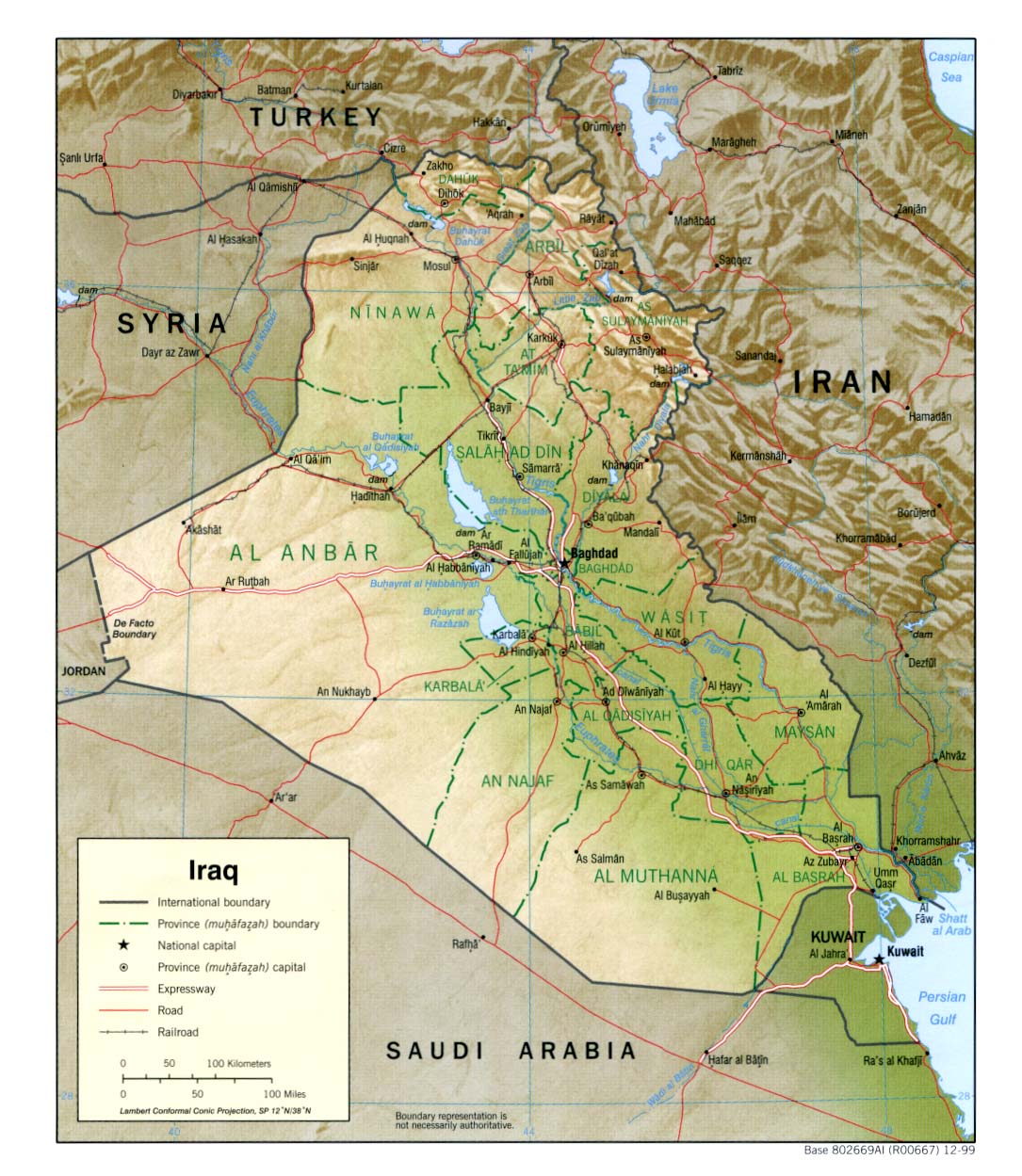
Posted: Thu Jul 31, 2008 12:32 am
by Shannon V. OKeets
Here is a screen shot of Iraq after the discussed changes. The data was modified by Patrice and this is part of version 10.00, which I am about to upload.

RE: MWiF Map Review - India & Burma
Posted: Fri Aug 01, 2008 8:48 pm
by Incy
I still think Jordan is to large, and Iraq certainly does not reach far enough west.
Just compare distances between east med shore<->iraq/jordan border<->
and iraq/jordan border<-> Baghdad
I suggest Syria give hex 2W of lake Tharthar iraqi. Transjordan gives 2 eastermost hexes to Iraq. Transjordan give SE corner + hex north of that to saudi.