Page 2 of 8
RE: Africa Bitmaps
Posted: Wed Oct 18, 2006 6:52 pm
by Shannon V. OKeets
3rd in the series. Lake Chad has problems, but that is easily fixed in the data files.

RE: Africa Bitmaps
Posted: Wed Oct 18, 2006 6:54 pm
by Shannon V. OKeets
This screen shot overlaps with the ones from yesterday for southern Africa. All of these are zoom level 3.

RE: Africa Bitmaps
Posted: Wed Oct 18, 2006 6:57 pm
by Shannon V. OKeets
Lake Victoria also has data problems, as do some of the smaller lakes (they are missing their tips).
We need the rivers to be thicker especially when they run through the jungle and mountains.

RE: Africa Bitmaps
Posted: Wed Oct 18, 2006 6:59 pm
by Shannon V. OKeets
The horn of Africa, the Red Sea, and the upper Nile. Some pretty famous places.

RE: Africa Bitmaps
Posted: Wed Oct 18, 2006 7:01 pm
by Shannon V. OKeets
Most of Saudi Arabia and the Persian Gulf. The hexes above Kuwait haven't had their bitmaps done yet. They will be part of the Caucasus segment.

RE: Africa Bitmaps
Posted: Wed Oct 18, 2006 7:06 pm
by Shannon V. OKeets
Last in the series of 8. I kicked this one up to zoom level 5 (the others were at 3). Looking at the Nile, you can see the 3 variations we have tried for the rivers. The northern portion is correctly done. I have the correction for the center piece lying around somewhere - I think it is under that chair over there. The southern river bitmaps need thickening; not a lot, but enough to match the northern ones.

RE: Africa Bitmaps
Posted: Wed Oct 18, 2006 7:19 pm
by Ballista
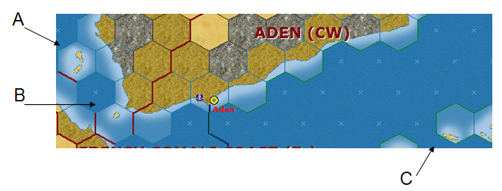
A small thing here, but something about islands and their fade outlining seems cut off when it approaches a hexside (compare "A" with "B" and "C" below:
]
Many apologies- I can't seem to get the picture to embed properly

Finally got it though

RE: Africa Bitmaps
Posted: Wed Oct 18, 2006 7:27 pm
by Shannon V. OKeets
ORIGINAL: Ballista
A small thing here, but something about islands and their fade outlining seems cut off when it approaches a hexside (compare "A" with "B" and "C" below:
]
Many apologies- I can't seem to get the picture to embed properly
Finally got it though
Yes, I see your point. But this is sort of the nature of the beast, since we need to have all the all-sea hexes look alike. The blending that the artist can achieve has its limits. If you look at the hex the text "(CW)" is in, a similar situation exists. And of course the land hex terrain does not blend whatsoever.
RE: Africa Bitmaps
Posted: Wed Oct 18, 2006 7:29 pm
by Ballista
That's cool. Just something I noticed pouring over the maps segments (map-o-phile that I am
)
RE: Africa Bitmaps
Posted: Wed Oct 18, 2006 9:28 pm
by Incy
There are
-3 inland hexes that are designated coastal in nothwestern Mauretania
-2 in eastern Senegal
-hex SW of Bamako
-hex that has the IVO in IVORY COAST
-hex NW of Accra
-Hex 3 E Libreville
-All of the Quatarra depression (or?)
RE: Africa Bitmaps
Posted: Wed Oct 18, 2006 9:31 pm
by Froonp
ORIGINAL: Incy
There are 3 inland hexes that are designated coastal in nothwestern Mauretania
Caught them this time, and already had the data changed [:D].
RE: Africa Bitmaps
Posted: Wed Oct 18, 2006 9:37 pm
by Incy
I edited my message, more coastal suprises...
RE: Africa Bitmaps
Posted: Wed Oct 18, 2006 9:48 pm
by Froonp
ORIGINAL: Incy
There are
-3 inland hexes that are designated coastal in nothwestern Mauretania
-2 in eastern Senegal
-hex SW of Bamako
-hex that has the IVO in IVORY COAST
-hex NW of Accra
-Hex 3 E Libreville
-All of the Quatarra depression (or?)
OK, you win, I saw none of them except the 3 firs.
SW of Bamako there were 4 hexes !!!!!!
Also, one was coastal to Mouths of the Amazons.
Steve, it would be good to have some kind of way to see coastal hexes better, only for tracking wrong ones, not for the game.
RE: Africa Bitmaps
Posted: Wed Oct 18, 2006 10:20 pm
by Peter Stauffenberg
I noticed these lake hexsides are not done properly:
* Lake Tanganyika SE corner (Dar Es Salaam 7xW+2xSW)
* Lake Rukva SW corner (Dar Es Salaam 7xW+2xSW)
* Lake Nyasa west bank (Elisabethville 6xE)
* Lake Nyasa west bank (N'Dola 5xE)
* Lake Nyasa S corner (Blantyre 1xW)
* Lake Chad N corner (Fort Lamy 4xNW+1xW)
* Lake Chad E bank (Fort Lamy 4xNW)
* Lake Chad E bank (Fort Lamy 3xNW)
* Lake Chad SW corner (Fort Lamy 2xW+1xNW
* Lake Rudolf S corner (Nairobi 3xNE+1xNW)
* Lake Victoria E bank (Nairobi 2xNW)
* Lake Victoria E bank (Nairobi 2xW)
* Lake Victoria E bank (Nairobi 2xW+1xSW)
* Lake Victoria S bank (Mwanza)
* Lake Victoria S bank (Mwanza 1xW)
* Lake Victoria W bank (Mwanza 1xW+1xNW)
* Lake Victoria W bank (Mwanza 1xW+2xNW)
* Lake Victoria W bank (Mwanza 3xNW)
* Lake Edward SE corner (Kampala 2xW+2xSW)
* Lake Tana N corner (Asmara 3xSW)
RE: Africa Bitmaps
Posted: Wed Oct 18, 2006 10:26 pm
by Froonp
I think I've corrected all these, thanks, I'll shoot the CSV at Steve, and I'm sure he'll grant you with a magnificent view of the Lake region. [:D]
RE: Africa Bitmaps
Posted: Thu Oct 19, 2006 4:04 am
by Shannon V. OKeets
Lakes with Patrice's data corrections.

RE: Africa Bitmaps
Posted: Thu Oct 19, 2006 4:05 am
by Shannon V. OKeets
Gabon - home of the Free French. Some corrections around Leopoldville.

RE: Africa Bitmaps
Posted: Thu Oct 26, 2006 6:19 pm
by Shannon V. OKeets
Rob has redone all the rivers in Africa, making them thicker so they will be easy to see when going through mountains, jungle, and swamp. He has also moved them slightly so they do not overlie the hex grid as much. That's to prevent rivers and country borders from obscuring each other.

RE: Africa Bitmaps
Posted: Thu Oct 26, 2006 6:21 pm
by Shannon V. OKeets
So I thought I would post a mini-tour of Africa with the final (I hope) bitmaps.

RE: Africa Bitmaps
Posted: Thu Oct 26, 2006 6:27 pm
by Shannon V. OKeets
I really like the work Patrice and Rob have done on the Cape Verde Islands. Patrice's passion for naming all the islands looks great here. There is plenty of room so the names do not make the image cluttered. And being able to refer to by name to Santo Antao as an important hex because it straddles 2 sea areas is much better than giving hex coordinates.
