Page 2 of 3
Re: Left Unsupervised Map Mod
Posted: Tue Jan 31, 2023 11:59 am
by Jarosak
hi 22sec getting errors when i try to load scenarion in single player
Re: Left Unsupervised Map Mod
Posted: Tue Jan 31, 2023 2:40 pm
by CapnDarwin
All of the map files need to be in the Maps folder and the scenario in the scenario folder. Can you post your errors?
Re: Left Unsupervised Map Mod
Posted: Tue Jan 31, 2023 11:49 pm
by Jarosak
CapnDarwin wrote: Tue Jan 31, 2023 2:40 pm
All of the map files need to be in the Maps folder and the scenario in the scenario folder. Can you post your errors?
Re: Left Unsupervised Map Mod
Posted: Tue Jan 31, 2023 11:55 pm
by Jarosak
I think scenario was made with different version of the game
Re: Left Unsupervised Map Mod
Posted: Wed Feb 01, 2023 12:35 am
by 22sec

Yep
The next version will work. Sorry. You can still create a scenario with the map. I build the next one with the current public version.
Re: Left Unsupervised Map Mod
Posted: Wed Feb 01, 2023 2:40 am
by JohnOs
I like it and have no problem running it. I would like to see if you can post the other map for this scenario test. This map seems too dark for me

Also a couple of things that I have seen and will post later.

- A Fresh Look.jpg (1.88 MiB) Viewed 3919 times
Re: Left Unsupervised Map Mod
Posted: Wed Feb 01, 2023 3:11 am
by 22sec
Version 4 map coming tomorrow along with a new scenario.
- Bayreuth3.jpg (1.28 MiB) Viewed 3867 times
Re: Left Unsupervised Map Mod
Posted: Wed Feb 01, 2023 1:22 pm
by CapnDarwin
Are you running on a 5x1 monitor? That screen is crazy long.

Re: Left Unsupervised Map Mod
Posted: Wed Feb 01, 2023 7:46 pm
by 22sec
I thought my 49" 4K looked good.

Version 4 is up in the first thread.
The big changes, added tertiary roads, tweaked some values in the Map Data file, and added finer detail to png to match the satellite in-game used jpg file.
Also discuss these in my Maps thread.
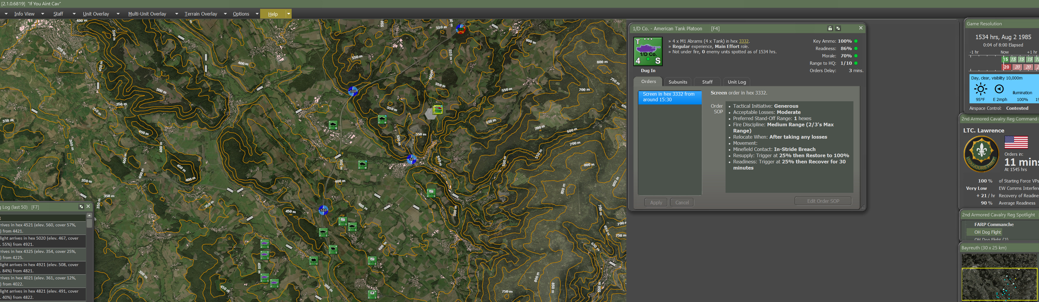
New Scenario up as well...set in August 1985!
This scenario is playable if you haven't updated to what is as of today (2/1) the beta patch (and if you have too).
Tried a different approach with the scenario brief too. I got my hiney handed to me in my first test, but it was fun and I bled the Soviet's in the process.
https://twitter.com/22sec2/status/16208 ... hoIsNHfjgg
Re: Left Unsupervised Map Mod
Posted: Fri Feb 03, 2023 1:01 pm
by caygraph
Hi, I'm really impressed. Are you using Global Mapper? is there any chance for a quick workflow? especially in terms of cropping the map to a "reasonable" size (i mean scale) and what layer are you using (topo, dem).
Re: Left Unsupervised Map Mod
Posted: Fri Feb 03, 2023 7:26 pm
by 22sec
caygraph wrote: Fri Feb 03, 2023 1:01 pm
Hi, I'm really impressed. Are you using Global Mapper? is there any chance for a quick workflow? especially in terms of cropping the map to a "reasonable" size (i mean scale) and what layer are you using (topo, dem).
I do use GM to export the data and images for the area I want to map. I then use GIMP to ultimately create the png file for the Map Value Editor. You can use whatever jpg you want for the image used in-game. That's the quick version.
Data: I use whatever data I can load or access via GM. For maps OTS uses that means older Landsat images and topo maps to ensure historical accuracy. There is now even Corrine Land Data shp file from 1990 available that is used as well.
Extracting data: The data needs to be exported at 7.8125m per pixel. (500m hex/64 pixel sized hexagon)
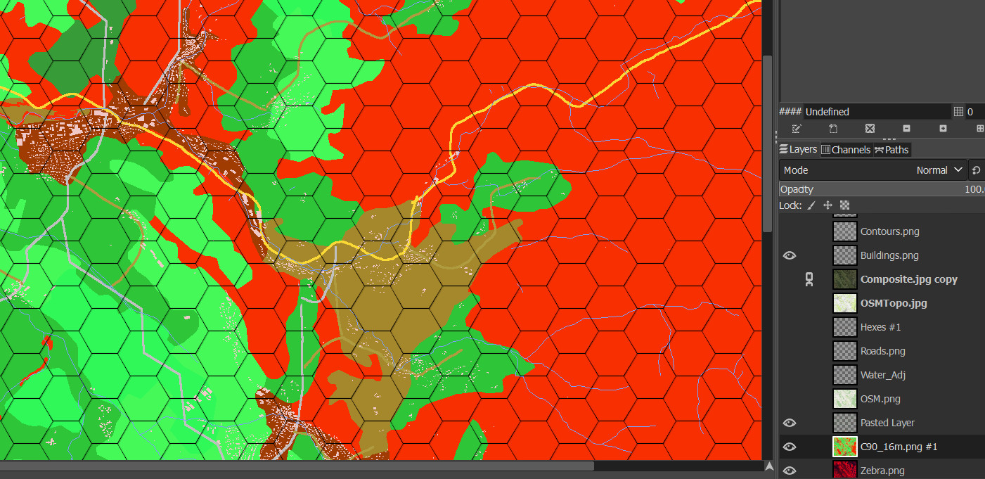
GIMP: The key is to add the hexes to a layer. Fortunately if you use Filters>Distorts>Mosaics>Hexagons (Tile size=64), the hexes are not only the size used by the FC engine, they match perfectly with the locations of the hexes used in the game, so you don't have to spend anytime lining anything up. Below is what it currently looks like for this map.
- GIMP.jpg (399.09 KiB) Viewed 3707 times
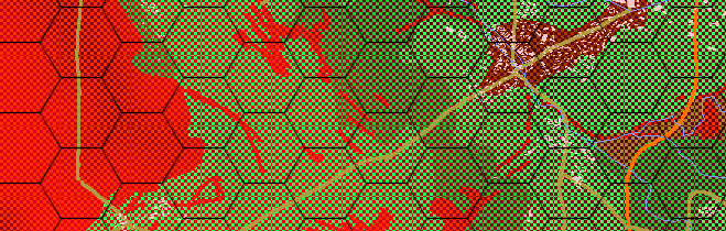
The other piece is each hex has to include elevation data in addition to the terrain data. I use a pattern to mask part of the terrain data, allowing the elevation layer underneath to be included in the png as well.
- GIMP2.jpg (177.59 KiB) Viewed 3707 times
Re: Left Unsupervised Map Mod
Posted: Fri Feb 03, 2023 10:43 pm
by caygraph
Thank you! I really appreciate. i'll try your way.
Re: Left Unsupervised Map Mod
Posted: Sat Feb 04, 2023 2:00 pm
by caygraph
22sec - could you provide some info about export from GM, because i stuck at the moment when GM tell me "there are a lot of data..." and the export proces, even the small map (7x4km) is extra long...
EDIT: much better when i export wit 7.812 m per pixel
but the map resolution is small..
last question: how you add elevation info into hex? the same as terrain type? by color?
Re: Left Unsupervised Map Mod
Posted: Wed Feb 08, 2023 2:58 pm
by 22sec
I apologize for the delay in my response. Yes elevation is a RGB as defined in the Map DataType file. It has to be visible, readable when scanned, in each hex. I typically do my elevation data as the base layer, my terrain data, which I apply a pattern to so that enough of each hex elevation becomes visible. I then do water, followed by roads. For the Bayreuth Concept map I added buildings as a layer.
I loathe the game’s inherit 50m elevation levels. I’m still trying to decide if my personal preference for maps is some kind of level system, probably 16m, or what you see in the Bayreuth map where each hex is the average scanned elevation data point per hex. I digress….
Re: Left Unsupervised Map Mod
Posted: Wed Feb 08, 2023 3:56 pm
by caygraph
Great! Thank you! so if i good understand: for places where are height information and e.g trees ->you use pattern "filling" with two colors (one color for elevation, another one for land type (trees). and if there is a road, simply use color for height info + draw road with proper color?
I really appreciate your help!
PS. Regarding the map vaules and rgb values -> I have already found it in your earlier posts
thnx!!
Re: Left Unsupervised Map Mod
Posted: Fri Feb 10, 2023 9:28 am
by caygraph
22sec wrote: Fri Feb 03, 2023 7:26 pm
Extracting data: The data needs to be exported at 7.8125m per pixel. (500m hex/64 pixel sized hexagon)
Hi, I am trying to export a map at 7.8125m and the scale is not 500m per hex. value=15 got me the right scale I guess, so where am I going wrong?
Re: Left Unsupervised Map Mod
Posted: Sun Feb 19, 2023 1:05 pm
by caygraph
@22sec - you don't have to reply for my questions anymore...

"
A need or problem encourages creative efforts to meet the need or solve the problem.- Plato"
Re: Left Unsupervised Map Mod
Posted: Sun Feb 19, 2023 5:33 pm
by CapnDarwin
He will be back. He is out of town at the moment.
Re: Left Unsupervised Map Mod
Posted: Sun Feb 19, 2023 5:50 pm
by caygraph
Sure! no problem! he already helped me a lot
Re: Left Unsupervised Map Mod
Posted: Tue Feb 21, 2023 8:54 am
by Comcikda
For Hex styles, I recommend that you use a vector drawing tool such as inkscape so that you can make more detailed adjustments to details such as chamfers.
 Yep
Yep