Page 17 of 23
RE: Modifications to MWiF Scandinavia Map portion
Posted: Fri Oct 06, 2006 7:52 pm
by Shannon V. OKeets
Last in the series. Together these cover almost all of the Scandinavia. The northern tip was ok, so yesterday's screen shot is unchanged.
The only thing I see here that needs improvement is the placement of lake names (so they do not overlie the resources).
I am thinking that the lake name should be colored to match the lake color. Also the font size for the lakes seems too large. It is too similar to the city names. Ideas?
I am not sure about the color for the river names. Clearly using the new darker river color is wrong because it would be hard to read. But the current brighter blue against dark green (i.e., forest) isn't easy to read either.
Now that the coastal hexes are all in, the placement of the port icons and the names for the ports needs to be reviewed. most of them are fine as is, but a few aren't: Trondheim, Lulea, others?

RE: Modifications to MWiF Scandinavia Map portion
Posted: Fri Oct 06, 2006 8:03 pm
by Froonp
I am thinking that the lake name should be colored to match the lake color. Also the font size for the lakes seems too large. It is too similar to the city names. Ideas?
Same color of the lakes would be to clear IMO. For the font size, these seem large because the lakes are small. For Ladoga and Great Lakes the font does not seem so large. Maybe simply small lakes (1 or 1-2 hexsides) should not have names
I am not sure about the color for the river names. Clearly using the new darker river color is wrong because it would be hard to read. But the current brighter blue against dark green (i.e., forest) isn't easy to read either.
The current blue is ok for me. IMO, reading river names is secondary. I think they are small enough as they are.
Now that the coastal hexes are all in, the placement of the port icons and the names for the ports needs to be reviewed. most of them are fine as is, but a few aren't: Trondheim, Lulea, others?
I'll make all Label position modifications when I'll have the map myself.
I intended to review all the map labels (and gather all suggestions about this too) when the playtesters and I would have received the new map too.
RE: Modifications to MWiF Scandinavia Map portion
Posted: Fri Oct 06, 2006 8:20 pm
by Froonp
I am thinking that the lake name should be colored to match the lake color. Also the font size for the lakes seems too large. It is too similar to the city names. Ideas?
About Lakes, maybe small lakes (1-2 hexsides) should have their names reduced in size (size 9, that is the same as Rivers), and big lakes (3-4 hexsides or more, or real lake hexes) should keep the same size (10).
Also, maybe the game should have a program routine that does not display the labels of less than size 10 if at zoom level 1-2 (both the smallest ones).
Maybe at the smallest level of zoom, all names size 10 (cities and smallest territories) should disappear, and maybe city & ports symbols should be enlarged (twice the size).
RE: Modifications to MWiF Scandinavia Map portion
Posted: Fri Oct 06, 2006 8:28 pm
by wfzimmerman
ORIGINAL: Shannon V. OKeets
ORIGINAL: wfzimmerman
I really think it's a mistake to have the glacier hex have perfectly hexagonal sides.
Maybe, but this is the only hex in the world like this. The other ice hexes are in large groups (not counting the ice island hex on the Norwegian coast).
All the other terrain suffers from the same effect. For example, the Forest hex to the NW of the glacier hex looks weird because it is isolated. We are just used to seeing the other terrain types and the white hex jumps out at the viewer.
You could fix it by having the hex have grey mountain trim around the edges of the glacier so it would blend into its neighbors.
I realize this is a point solution, but it looks like a hole in the map as is.
RE: Modifications to MWiF Scandinavia Map portion
Posted: Fri Oct 06, 2006 8:31 pm
by Shannon V. OKeets
ORIGINAL: Froonp
I am thinking that the lake name should be colored to match the lake color. Also the font size for the lakes seems too large. It is too similar to the city names. Ideas?
About Lakes, maybe small lakes (1-2 hexsides) should have their names reduced in size (size 9, that is the same as Rivers), and big lakes (3-4 hexsides or more, or real lake hexes) should keep the same size (10).
Also, maybe the game should have a program routine that does not display the labels of less than size 10 if at zoom level 1-2 (both the smallest ones).
Maybe at the smallest level of zoom, all names size 10 (cities and smallest territories) should disappear, and maybe city & ports symbols should be enlarged (twice the size).
Too many changes for my head to hold.
Using a smaller size font for smaller lakes seems good. This is all controllable by data in the NAM CSV file I believe.
As for what is shown at lower levels of zoom, I would prefer to review that later. So far I am changing how the rail lines are shown, but the rest is all proportional.
RE: Modifications to MWiF Scandinavia Map portion
Posted: Fri Oct 06, 2006 8:32 pm
by Shannon V. OKeets
ORIGINAL: wfzimmerman
ORIGINAL: Shannon V. OKeets
ORIGINAL: wfzimmerman
I really think it's a mistake to have the glacier hex have perfectly hexagonal sides.
Maybe, but this is the only hex in the world like this. The other ice hexes are in large groups (not counting the ice island hex on the Norwegian coast).
All the other terrain suffers from the same effect. For example, the Forest hex to the NW of the glacier hex looks weird because it is isolated. We are just used to seeing the other terrain types and the white hex jumps out at the viewer.
You could fix it by having the hex have grey mountain trim around the edges of the glacier so it would blend into its neighbors.
I realize this is a point solution, but it looks like a hole in the map as is.
Special terrain depiction for 1 hex out of 70,200 on the map? No.
RE: Modifications to MWiF Scandinavia Map portion
Posted: Fri Oct 06, 2006 8:46 pm
by Shannon V. OKeets
Patrice, you had asked about the lakes near Petsamo. They look ok to me.

RE: Modifications to MWiF Scandinavia Map portion
Posted: Fri Oct 06, 2006 9:06 pm
by Froonp
Patrice, you had asked about the lakes near Petsamo. They look ok to me.
Yes, they are ok. Must have been the combination of the level of zoom and JPG conversion.
RE: Modifications to MWiF Scandinavia Map portion
Posted: Fri Oct 06, 2006 11:08 pm
by Incy
For the black hexsides at sea problem, it would be very nice if it would be possible to make all all-sea hexsides blue, and all all land and mixed hexides black.
This would really facilitate identification of invadable hexes, and I think it would look good too.
Incy
RE: Modifications to MWiF Scandinavia Map portion
Posted: Fri Oct 06, 2006 11:12 pm
by Incy
The same arrangement would also help players figure out all-sea lake hexides. Many hexes have very ambigous graphics.
Hornavatn and Storsjön for instance are not lakes at all as drawn(by the rulebook).
I think many players would interpret them as all-lake hexides, though. But a rule lawyer would rightly argue they're not.
RE: Modifications to MWiF Scandinavia Map portion
Posted: Fri Oct 06, 2006 11:18 pm
by Toed
You asked for picky so here is it [:)]
5. The port of Sundsvall should be moved to the north inside its hex so that is adjacent to Indalsälven. It is actually somthing like 6 km from the actual rivermouth but considering the scale we're working it looks better closer to the river imo.
RE: Modifications to MWiF Scandinavia Map portion
Posted: Sat Oct 07, 2006 12:09 am
by Shannon V. OKeets
ORIGINAL: Incy
For the black hexsides at sea problem, it would be very nice if it would be possible to make all all-sea hexsides blue, and all all land and mixed hexides black.
This would really facilitate identification of invadable hexes, and I think it would look good too.
Incy
No. We had this discussion before. The arguments for and against this were listed then - somewhere. My decision was then, and now, is no.
I'll remove the black lines from the coastal hexes.
RE: Modifications to MWiF Scandinavia Map portion
Posted: Sat Oct 07, 2006 12:15 am
by Shannon V. OKeets
ORIGINAL: Incy
The same arrangement would also help players figure out all-sea lake hexides. Many hexes have very ambigous graphics.
Hornavatn and Storsjön for instance are not lakes at all as drawn(by the rulebook).
I think many players would interpret them as all-lake hexides, though. But a rule lawyer would rightly argue they're not.
You are right that the graphics for those 2 lake hexsides have to be improved. They should overlie the hexside so that the entire black line separating the hexes is surrounded by blue. Running through the middle off the hex, close to the hexside, sort of works for rivers, but fails for the lakes. If you see other lake hexsides like that, please point them out.
RE: Modifications to MWiF Scandinavia Map portion
Posted: Sat Oct 07, 2006 1:01 am
by Incy
-Mjøsa? (lower left corner)
-Store Lulevatten
-Hexes NE and NW of Trondheim
-Lofoten (islands 3 and 4 hexes west of Narvik) (but add 1-2 straits in Lofoten?) (also a name for the group of island would be nice. The SW part is called Lofoten, the NE part is called Vesterålen)
ORIGINAL: Shannon V. OKeets
ORIGINAL: Incy
The same arrangement would also help players figure out all-sea lake hexides. Many hexes have very ambigous graphics.
Hornavatn and Storsjön for instance are not lakes at all as drawn(by the rulebook).
I think many players would interpret them as all-lake hexides, though. But a rule lawyer would rightly argue they're not.
You are right that the graphics for those 2 lake hexsides have to be improved. They should overlie the hexside so that the entire black line separating the hexes is surrounded by blue. Running through the middle off the hex, close to the hexside, sort of works for rivers, but fails for the lakes. If you see other lake hexsides like that, please point them out.
RE: Modifications to MWiF Scandinavia Map portion
Posted: Sat Oct 07, 2006 1:09 am
by Incy
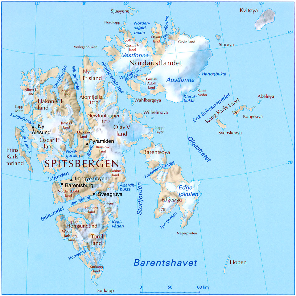
Names for the arctic ilands should be changed.
"bear island" is english. "Bjørnøya" in norwegian.
"Spitzbergen" is german. "Svalbard" in norwegian. (The main island of the archipelagio is called spitsbergen (with S, not Z))
The map for Svarlbard is quite poor, for better map and proper names, see:
RE: Modifications to MWiF Scandinavia Map portion
Posted: Sat Oct 07, 2006 1:13 am
by Incy
-2 sea borders (nort sea<->norwegian, north sea<->baltic) dont connect all the way to shore
-Svalbard should have several glacier hexes, not only tundra (se map in previous post)
RE: Modifications to MWiF Scandinavia Map portion
Posted: Sat Oct 07, 2006 1:32 am
by Shannon V. OKeets
ORIGINAL: Incy
-2 sea borders dont connect all the way to shore
-Svalbard should have several glacier hexes, not only tundra (se map in previous post)
Thanks, changing terrain is trivial. But looking at that map ... Brrrr.
RE: Modifications to MWiF Scandinavia Map portion
Posted: Sat Oct 07, 2006 1:35 am
by Shannon V. OKeets
Here is the coast line without those annoying black hexgrid lines.
Patrice, about the river that goes nowhere, perhaps it should have a little tail instead of ending sharply at the hex boundary?

RE: Modifications to MWiF Scandinavia Map portion
Posted: Sat Oct 07, 2006 8:30 am
by Froonp
ORIGINAL: Incy
For the black hexsides at sea problem, it would be very nice if it would be possible to make all all-sea hexsides blue, and all all land and mixed hexides black.
This would really facilitate identification of invadable hexes, and I think it would look good too.
Incy
I agree. Good idea.
RE: Modifications to MWiF Scandinavia Map portion
Posted: Sat Oct 07, 2006 8:30 am
by Froonp
ORIGINAL: Incy
The same arrangement would also help players figure out all-sea lake hexides. Many hexes have very ambigous graphics.
Hornavatn and Storsjön for instance are not lakes at all as drawn(by the rulebook).
I think many players would interpret them as all-lake hexides, though. But a rule lawyer would rightly argue they're not.
Good idea too !!! [:D]
I hope this is doable.