Re: Left Unsupervised Map Mod
Posted: Tue Feb 21, 2023 9:06 pm
@Comcikda - i dont get it.. could you give some examples? i bet that maps was created in photoshop like apps. so i gladly hear what you mean. thnx
What's your Strategy?
https://forums.matrixgames.com:443/
22sec, hell of a thread you have here. I just wanted to send my thanks to you for all of the work you are putting into these maps and explaining the process so clearly.22sec wrote: Fri Feb 03, 2023 7:26 pm
I do use GM to export the data and images for the area I want to map. I then use GIMP to ultimately create the png file for the Map Value Editor. You can use whatever jpg you want for the image used in-game. That's the quick version.
Data: I use whatever data I can load or access via GM. For maps OTS uses that means older Landsat images and topo maps to ensure historical accuracy. There is now even Corrine Land Data shp file from 1990 available that is used as well.
Extracting data: The data needs to be exported at 7.8125m per pixel. (500m hex/64 pixel sized hexagon)
GIMP: The key is to add the hexes to a layer. Fortunately if you use Filters>Distorts>Mosaics>Hexagons (Tile size=64), the hexes are not only the size used by the FC engine, they match perfectly with the locations of the hexes used in the game, so you don't have to spend anytime lining anything up. Below is what it currently looks like for this map.GIMP.jpg
The other piece is each hex has to include elevation data in addition to the terrain data. I use a pattern to mask part of the terrain data, allowing the elevation layer underneath to be included in the png as well. GIMP2.jpg
It's good stuff, and if I was making tabletop wargames I would. For png files for the game's Map Value Editor all I need my hex grid to do is make sure my roads and other terrain are positioned correctly. I'm not worried about the aesthetics of the png map, as long as the end result is correct, and it is.Comcikda wrote: Wed Feb 22, 2023 3:28 am To be honest I don't think it's a good idea to use ps/gimp to make shapes like map meshes, a vector drawing tool like inkscape is much better suited for this workflow, see my screenshot. I can easily draw the entire map with the grid style i want and then import the grid to ps/gimp in formats like svg or even png before post processing.
This is how I make my desktop wargame.
1.jpg
2.jpg
3.jpg
Thank you. Off topic, I am trying to get better at the CM map editing process for another opportunity. Any place to find any good tips?Bil H wrote: Mon Feb 27, 2023 4:36 pm22sec, hell of a thread you have here. I just wanted to send my thanks to you for all of the work you are putting into these maps and explaining the process so clearly.22sec wrote: Fri Feb 03, 2023 7:26 pm
I do use GM to export the data and images for the area I want to map. I then use GIMP to ultimately create the png file for the Map Value Editor. You can use whatever jpg you want for the image used in-game. That's the quick version.
Data: I use whatever data I can load or access via GM. For maps OTS uses that means older Landsat images and topo maps to ensure historical accuracy. There is now even Corrine Land Data shp file from 1990 available that is used as well.
Extracting data: The data needs to be exported at 7.8125m per pixel. (500m hex/64 pixel sized hexagon)
GIMP: The key is to add the hexes to a layer. Fortunately if you use Filters>Distorts>Mosaics>Hexagons (Tile size=64), the hexes are not only the size used by the FC engine, they match perfectly with the locations of the hexes used in the game, so you don't have to spend anytime lining anything up. Below is what it currently looks like for this map.GIMP.jpg
The other piece is each hex has to include elevation data in addition to the terrain data. I use a pattern to mask part of the terrain data, allowing the elevation layer underneath to be included in the png as well. GIMP2.jpg
Thx CapnDarwin !CapnDarwin wrote: Tue Feb 28, 2023 3:54 am You have to go into the Scenario editor and then load the map to view it.
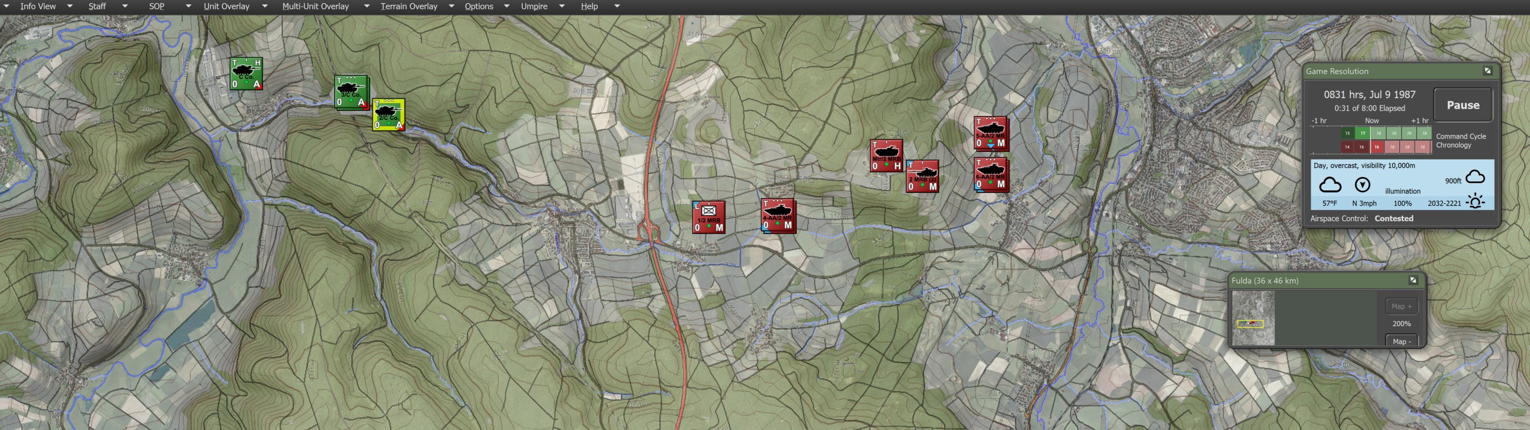
I made some tweaks to the topo jpg. The default color scheme from OSM Topo Maps is hard on the eyes in FC. I would mute the map colors using the setting in-game.pburton2000 wrote: Wed Mar 01, 2023 1:14 am Any reason why my TOPO map would so lightly coloured compared to others who have posted it in this forum ? I can barely make out the HEX overlay ?
Not sure if you have seen this thread re: CM maps... looks right up your alley. https://community.battlefront.com/topic ... /#comments22sec wrote: Tue Feb 28, 2023 5:16 pm Thank you. Off topic, I am trying to get better at the CM map editing process for another opportunity. Any place to find any good tips?