Page 25 of 35
Burma Road
Posted: Mon Nov 06, 2006 9:21 pm
by Froonp
While browsing the map, both real and MWiF's one, I saw something that I do not like.
It seems that the Burma Road, at least the part that is in Burma, is not well traced in MWiF [:(].
Look at the attached picture.
Top left : How MWiF has it now.
Top Right : As WiF FE has it.
We see by comparing them that MWiF does a good job in making the map the same :
The road starts from the
northern "unfinished" railway, toward China.
Bottom left and Right are maps of the area that show the Burma Road.
And both show it starting from Lashio (the end point of the
southern "unfinished" railway), toward China.
Well, what do you think about this ?
Are both bottom maps an error ?
If not, should MWiF has a wrong Burma Road, just for the pleasure of repeating the WiF FE map error ?
Opinions ?

RE: Burma Road
Posted: Mon Nov 06, 2006 11:12 pm
by Shannon V. OKeets
ORIGINAL: Froonp
While browsing the map, both real and MWiF's one, I saw something that I do not like.
It seems that the Burma Road, at least the part that is in Burma, is not well traced in MWiF [:(].
Look at the attached picture.
Top left : How MWiF has it now.
Top Right : As WiF FE has it.
We see by comparing them that MWiF does a good job in making the map the same :
The road starts from the
northern "unfinished" railway, toward China.
Bottom left and Right are maps of the area that show the Burma Road.
And both show it starting from Lashio (the end point of the
southern "unfinished" railway), toward China.
Well, what do you think about this ?
Are both bottom maps an error ?
If not, should MWiF has a wrong Burma Road, just for the pleasure of repeating the WiF FE map error ?
Opinions ?
Given the maps you have shown, I agree that it looks completely wrong on both the WIF FE and MWIF maps.
The road portion of the Burma Road should start from the end of the other/eastern rail line and extend due NE to the current MWIF rendering of the Burma Road - running into the hex contaiing the word Burma. The 3 hexes of the current MWIF Burma Road due west of that juncture should be removed.
RE: Burma Road
Posted: Mon Nov 06, 2006 11:14 pm
by Shannon V. OKeets
You could also label Lashio on the map since that was the rail head (apparently).
RE: Burma Road
Posted: Mon Nov 06, 2006 11:46 pm
by wosung
Good you re-checked the map, Patrice!
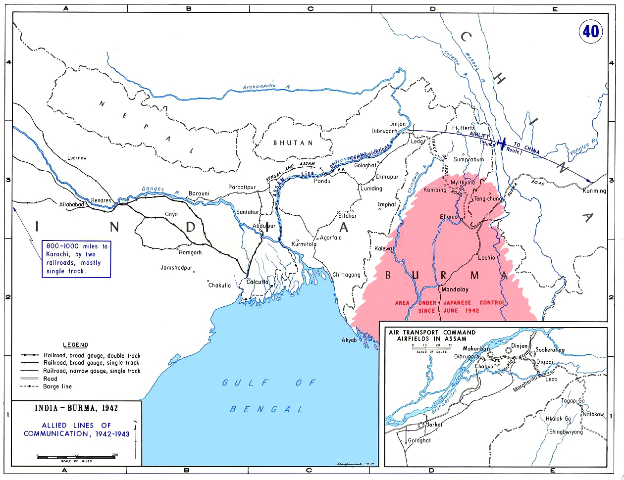
Not sure about the WIFFE rational, but perhaps by the 1130 solution they tried to capture both the Burma road (Mandalay-Lashio-Wanting-Kunming, built in 1938) and the Ledo road (Ledo-Myitkyina-Kunming, built from 1942? onwards and opened in 1945).
Perhaps one should think also about labeling Myitkyina (for it was THE key point for re-supplying China and therefore the main target of Stillwells Northern Burma campaign in 1944-45) and even Ledo (for it was the Western springboard for this offensive)
Sources: Barbara Tuchman, Stillwell.
http://upload.wikimedia.org/wikipedia/c ... 942-43.jpg
RE: Burma Road
Posted: Mon Nov 06, 2006 11:48 pm
by wosung
RE: Burma Road
Posted: Tue Nov 07, 2006 12:04 am
by wosung
Somehow, the graphic didn't load...[:@]
But Ledo road was Ledo-Mytkyina-Bhamo and then perheps som sixty miles to the east straight to the Burma road.
RE: Burma Road
Posted: Tue Nov 07, 2006 12:07 am
by Shannon V. OKeets
ORIGINAL: wosung
Somehow, the graphic didn't load...[:@]
But Ledo road was Ledo-Mytkyina-Bhamo and then perheps som sixty miles to the east straight to the Burma road.
I tried to fix the graphic but was unable.
RE: Burma Road
Posted: Tue Nov 07, 2006 7:27 am
by Froonp
ORIGINAL: Shannon V. OKeets
You could also label Lashio on the map since that was the rail head (apparently).
I did that [:D].
I also added Ledo (name only), in India, as it was the starting point of the Ledo Road (finished in jan 1945, that linked Ledo to Lashio).
I also added Imphal & Kohima, 2 famous WWII places on the Indian / Burmese Border.
RE: Burma Road
Posted: Tue Nov 07, 2006 7:33 am
by Froonp
Given the maps you have shown, I agree that it looks completely wrong on both the WIF FE and MWIF maps.
The road portion of the Burma Road should start from the end of the other/eastern rail line and extend due NE to the current MWIF rendering of the Burma Road - running into the hex contaiing the word Burma. The 3 hexes of the current MWIF Burma Road due west of that juncture should be removed.
Feel free to look at it.
I did yesterday evening, and all the maps agree with the lower ones.
Perhaps, as Wosung said, ADG tried to show both the Burma & the Ledo Road, but I think personaly that they either did this for play balance reasons (make the Burma Road less easy to cut for the Japs), either they made a mistake. On the Pacific scaled maps, the difference is only 1 hex between both ways.
RE: Modifications to MWiF China Map portion
Posted: Wed Nov 08, 2006 11:23 pm
by Larry Smith
On the subject of Nanchang, wasn't there a Soviet volunteer group located somewhere in this area. I remember reading about how the Soviet airgroup, flying SB-2's, staged a raid on one of the Japanese airbases around Taipei, on Taiwan. I can't recall the timing, nor can I remember how to get to the WWII history site where I read this, but if the Soviet group was in this area, and flew that mission prior to Nanchang falling, perhaps the Japanese were responding to a threat? That, or they wanted to threaten Changsha from another direction.
RE: Modifications to MWiF China Map portion
Posted: Thu Nov 09, 2006 2:15 am
by Shannon V. OKeets
China map has arrived. Here is the Burma road in an open state (green)

RE: Modifications to MWiF China Map portion
Posted: Thu Nov 09, 2006 2:18 am
by Shannon V. OKeets
And here it is closed (cream). I want to tone this color down somewhat. CWIF used silver but that was hard to see against clear hexes. I tried gray and that disappeared completely in the mountains.

RE: Modifications to MWiF China Map portion
Posted: Thu Nov 09, 2006 2:19 am
by Shannon V. OKeets
Here's the portion of Indo-China that is done and southwestern China

RE: Modifications to MWiF China Map portion
Posted: Thu Nov 09, 2006 2:21 am
by Shannon V. OKeets
Southeastern China, including Formosa and the northern tip of the Philippines.

RE: Modifications to MWiF China Map portion
Posted: Thu Nov 09, 2006 2:26 am
by Shannon V. OKeets
Moving northwards up the coast. Several of the lakes are missing their tips.
[Patrice, the river names are easier to read if they are against clear terrain background.]
Patrice shepherded the long discussion on: what the terrain in these hexes should be; where the rivers should flow; which cities shuold be included, and a slew of other details. The final result sure looks good to me. [:)]
Thank you [&o] to everyone who participated in the China map revision.

RE: Modifications to MWiF China Map portion
Posted: Thu Nov 09, 2006 2:28 am
by Shannon V. OKeets
Continuing northwards. From Kaifeng to Peking to Port Arthur.

RE: Modifications to MWiF China Map portion
Posted: Thu Nov 09, 2006 2:32 am
by Shannon V. OKeets
Moving inland - the north. Here be Communists.

RE: Modifications to MWiF China Map portion
Posted: Thu Nov 09, 2006 2:33 am
by Shannon V. OKeets
Moving south. Here be Nationalists.

RE: Modifications to MWiF China Map portion
Posted: Thu Nov 09, 2006 2:35 am
by Shannon V. OKeets
9th and last in the series.
So you want to conquer China. Well I hope you brought enough rice and bullets.

RE: Modifications to MWiF China Map portion
Posted: Thu Nov 09, 2006 5:53 am
by Neilster
Green for open is logical but the white for the closed Burma Road doesn't seem quite right if open railways are almost the same colour and nearby. Another argument for changing the latter's colour perhaps [:D].
Except I just noticed the black railways in the zoomed out piccie. They look good. [:'(]
How about a bright red, orange or yellow? Purple? Some sort of warning colour.
Cheers, Neilster
