Page 5 of 7
Re: An update to the official game map
Posted: Wed Aug 10, 2022 5:03 pm
by RangerJoe
Wirraway_Ace wrote: Wed Aug 10, 2022 4:27 pm
Andrew,
This may already have been cited by others...
Nauru Island text is yellow in the stock map, which I understood to indicate an atoll. It appears to be small island.
~best
Mike
This is what wiki says with the current population:
"Nauru (/nɑːˈuːruː/ nah-OO-roo[9] or /ˈnaʊruː/ NOW-roo;[10] Nauruan: Naoero), officially the Republic of Nauru (Nauruan: Repubrikin Naoero) and formerly known as Pleasant Island, is an island country and microstate in Oceania, in the Central Pacific. Its nearest neighbour is Banaba Island in Kiribati, 300 km (190 mi) to the east.[11] It further lies northwest of Tuvalu, 1,300 km (810 mi) northeast of Solomon Islands,[12] east-northeast of Papua New Guinea, southeast of the Federated States of Micronesia and south of the Marshall Islands. With only a 21 km2 (8.1 sq mi) area, Nauru is the third-smallest country in the world behind Vatican City and Monaco, making it the smallest republic as well as the smallest island nation. Its population of about 10,000 is the world's second-smallest (not including colonies or overseas territories), after Vatican City. "
https://en.wikipedia.org/wiki/Nauru
Although that is not correct since the Sovereign Military Hospitaller Order of Saint John of Jerusalem, of Rhodes and of Malta actually has no territory or just one block within the borders of Rome, Italy.
https://en.wikipedia.org/wiki/Sovereign ... Saint_John
Re: An update to the official game map
Posted: Wed Aug 10, 2022 9:21 pm
by Nomad
Wirraway_Ace wrote: Wed Aug 10, 2022 4:27 pm
Andrew,
This may already have been cited by others...
Nauru Island text is yellow in the stock map, which I understood to indicate an atoll. It appears to be small island.
~best
Mike
From the manual
The base names of Very Small islands are colored light yellow, as opposed to white, to aid in
the identification of these islands on the map.
Re: An update to the official game map
Posted: Thu Aug 11, 2022 10:03 pm
by Wirraway_Ace
Nomad wrote: Wed Aug 10, 2022 9:21 pm
Wirraway_Ace wrote: Wed Aug 10, 2022 4:27 pm
Andrew,
This may already have been cited by others...
Nauru Island text is yellow in the stock map, which I understood to indicate an atoll. It appears to be small island.
~best
Mike
From the manual
The base names of Very Small islands are colored light yellow, as opposed to white, to aid in
the identification of these islands on the map.
Yes, I was imprecise when referring to an atoll. It is a
small island not
very small, so I think the issue (though minor) still stands. In the rules, very small islands have a stacking limit of 6,000, while small are 30,000.
Re: An update to the official game map
Posted: Mon Sep 05, 2022 11:14 pm
by Wirraway_Ace
Andrew, if you are still tracking map issues, hex 81 51 just NE of Changsha cannot be entered from hex 81 52 Siangtan, even though the map graphics indicate it should be possible. Units marching from 81 52 to 81 51 move as if going directly, then teleport to Changsha and try to cross the river to the NE.
Re: An update to the official game map
Posted: Mon Nov 14, 2022 8:48 pm
by Andrew Brown
Wirraway_Ace wrote: Mon Sep 05, 2022 11:14 pm
Andrew, if you are still tracking map issues, hex 81 51 just NE of Changsha cannot be entered from hex 81 52 Siangtan, even though the map graphics indicate it should be possible. Units marching from 81 52 to 81 51 move as if going directly, then teleport to Changsha and try to cross the river to the NE.
I stopped reviewing this thread a while ago after real life stuff intervened (as it often does for me), but I will get back to updating the maps and map data soon (could be a few weeks though).
Re: An update to the official game map
Posted: Sat Nov 19, 2022 11:29 pm
by RangerJoe
Howland Island, 1 hex NW of Baker Island should have an airstrip on it. Three were constructed starting in 1937 and even though rough, they were good enough for someone to try and land on them if she could have found them. They were still available when Japan bombed them in 1941. So not only should the possibility be better than a 0(0) airfield, but one should already exist.
"Kamakaiwi Field
Ground was cleared for a rudimentary aircraft landing area during the mid-1930s, in anticipation that the island might eventually become a stopover for commercial trans-Pacific air routes and also to further U.S. territorial claims in the region against rival claims from Great Britain. Howland Island was designated as a scheduled refueling stop for American pilot Amelia Earhart and navigator Fred Noonan on their round-the-world flight in 1937. Works Progress Administration (WPA) funds were used by the Bureau of Air Commerce to construct three graded, unpaved runways meant to accommodate Earhart's twin-engined Lockheed Model 10 Electra.
The facility was named Kamakaiwi Field after James Kamakaiwi, a young Hawaiian who arrived with the first group of four colonists. He was selected as the group's leader and he spent more than three years on Howland, far longer than the average recruit. It has also been referred to as WPA Howland Airport (the WPA contributed about 20 percent of the $12,000 cost). Earhart and Noonan took off from Lae, New Guinea, and their radio transmissions were picked up near the island when their aircraft reached the vicinity but they were never seen again.
Japanese attacks during World War II
A Japanese air attack on December 8, 1941, by 14 twin-engined Mitsubishi G3M "Nell" bombers of Chitose Kōkūtai, from Kwajalein islands, killed colonists Richard "Dicky" Kanani Whaley and Joseph Kealoha Keliʻhananui. The raid came one day after the Japanese attack on Pearl Harbor and damaged the three airstrips of Kamakaiwi Field. Two days later, shelling from a Japanese submarine destroyed what was left of the colony's buildings.[25] A single bomber returned twice during the following weeks and dropped more bombs on the rubble. The two survivors were finally evacuated by the USS Helm, a U.S. Navy destroyer, on January 31, 1942. Thomas Bederman, one of the two survivors, later recounted his experience during the incident in a March 9, 1942 edition of Life.[26] Howland was occupied by a battalion of the United States Marine Corps in September 1943 and was known as Howland Naval Air Station until May 1944.
All attempts at habitation were abandoned after 1944. Colonization projects on the other four islands, also disrupted by the war, were also abandoned.[27] No aircraft is known to have landed on the island, though anchorages nearby were used by float planes and flying boats during World War II. For example, on July 10, 1944, a U.S. Navy Martin PBM-3-D Mariner flying boat (BuNo 48199), piloted by William Hines, had an engine fire and made a forced landing in the ocean off Howland. Hines beached the aircraft and, though it burned, the crew were unharmed, rescued by the USCGC Balsam (the same ship that later took the USCG's Construction Unit 211 and LORAN Unit 92 to Gardner Island), transferred to a sub chaser and taken to Canton Island.[28] "
https://en.wikipedia.org/wiki/Howland_I ... aiwi_Field
Re: An update to the official game map
Posted: Sat Nov 19, 2022 11:37 pm
by RangerJoe
"In planning her flight around the globe, Earhart was able to hasten the construction of the landing fields. According to Earhart researcher Ric Gillespie, “On Thursday, January 7 [1936], the White House received a Western Union telegram from Amelia Earhart in Burbank, California, addressed to ‘Honorable Franklin D. Roosevelt.’” The telegram read, in part, “…I hope to land on tiny Howland Island where the government is about to establish an emergency field…Construction party with equipment due to sail from Honolulu next week. Am now informed apparently some question regarding WPA appropriation in amount [of] $3,000 which covers all costs other than those born[e] by me for this mid-Pacific pioneer landing field which [will be] permanently useful and valuable aeronautically and nationally…Under circumstances could you expedite, as immediate action vital…Please forgive this troublesome female flyer for whom this Howland project is key to world flight attempt.” The project was approved shortly thereafter, and by March 13, 1937 two landing fields were completed and the third well on its way – the longest being almost a mile (“Finding Amelia”)."
https://livingnewdeal.org/projects/kama ... nd-island/
Re: An update to the official game map
Posted: Sun Nov 20, 2022 12:32 pm
by Sardaukar
What is the reason to drastically reduce e.g. Eastern USA supply generation from 65 000 -> 1000 and Fuel from 40 000 -> 1000?
Also places like Aden cannot sustain even itself and bases in Egypt seem to be barely able to do that.
Re: An update to the official game map
Posted: Sun Nov 20, 2022 6:53 pm
by Yaab
The granaries of Egypt will open in September 1943. There is a REAL flood of supplies coming via convoys to Suez afterwards.
Re: An update to the official game map
Posted: Sun Nov 20, 2022 6:58 pm
by Sardaukar
Yaab wrote: Sun Nov 20, 2022 6:53 pm
The granaries of Egypt will open in September 1943. There is a REAL flood of supplies coming via convoys to Suez afterwards.
With these new supply levels...PBEM game will be over way before September 1943...
Since you don't have anything to ship out to supply on-map areas...
I don't know if any on-map production compensates any...but what I see is that in 1942, you cannot sustain even some off-map bases. Much less ship anything to places in dire need...like Australia.
Re: An update to the official game map
Posted: Tue Nov 22, 2022 3:43 pm
by Yaab
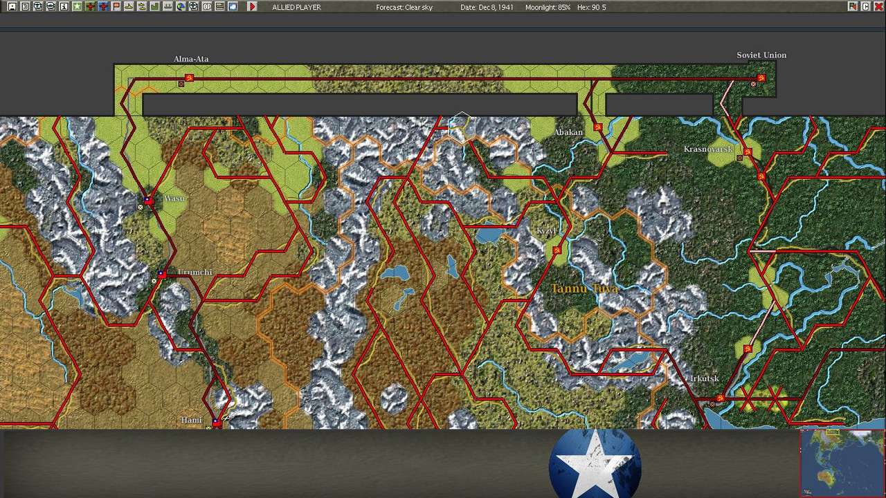
Scen 001, Beta Patch v1
Hex 90,5 does not have a minor road in pwhexe (the road visible on the map)
Re: An update to the official game map
Posted: Tue Nov 22, 2022 3:47 pm
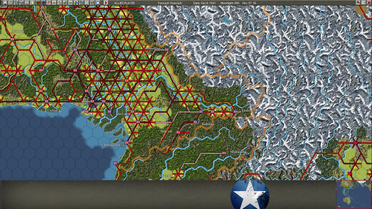
by Yaab
Scen001 , beta patch v1
Hex 57,36 does not have a trail leading NE in pwhexe (the hex has a minor railroad on the map and in pwhexe)
Re: An update to the official game map
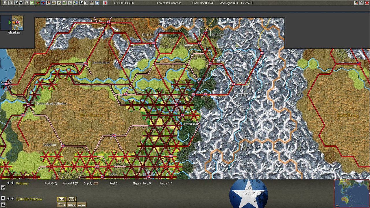
Posted: Tue Nov 22, 2022 6:23 pm
by Yaab
Scen001, Beta patch ver1
The hex NE of Peshawar has a minor road on the map, but no minor road is present in pwhexe
Re: An update to the official game map
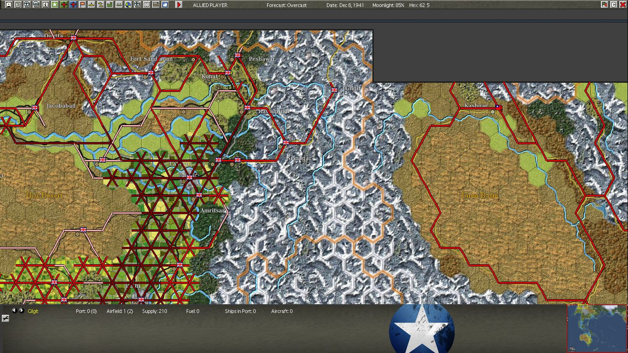
Posted: Tue Nov 22, 2022 6:26 pm
by Yaab
Scen001, beta patch v1
On the map, there is a minor road leading from Gilgit north. There is no minor road in pwhexe
Re: An update to the official game map
Posted: Wed Nov 23, 2022 12:13 am
by LargeSlowTarget
The road and rail between Moulmein and the dot base named "Sittang Bridge" should be cut.The Sittang is the river between Pegu and "Sittang Bridge" and a railway bridge had been constructed in 1908 across it. However, the river between Moulmein and "Sittang Bridge" is the Salween - and it has not been bridged until 2006. Before that date the river crossing was by ferry.
Same goes for the Brahmaputra crossings, that river remained un-bridged until 1962.
Re: An update to the official game map
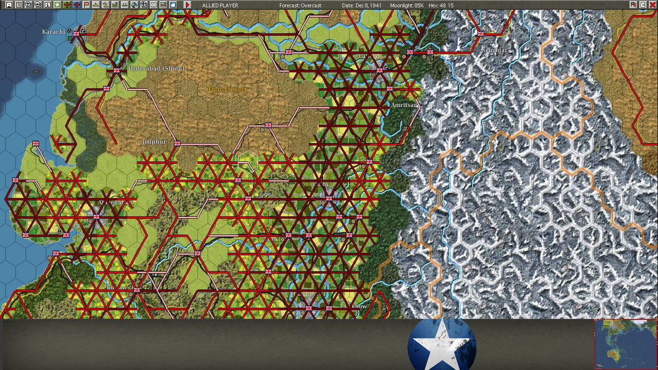
Posted: Sat Nov 26, 2022 7:56 am
by Yaab
Scen001, beta patch v1
Clear hex 48,15 lacks its intrinsic minor roads
Re: An update to the official game map
Posted: Sat Nov 26, 2022 2:04 pm
by RangerJoe
A question about the map:
From Subic Bay (78,76) to San Fernando (80, 74) is three hexes. From Subic Bay to Lingayen (79, 75) the movement is four hexes because even though they look connected by sea, hex 79, 74 does not connect. My PT boats at Subic Bay have to go through San Fernando to get to Lingayen even though it looks like they should be able to avoid San Fernando.
Is there an error somewhere here? If so, it is minor but still . . .
Re: An update to the official game map
Posted: Mon Nov 28, 2022 9:59 am
by Andrew Brown
Yaab wrote: Tue Nov 22, 2022 3:43 pm
Scen 001, Beta Patch v1
Hex 90,5 does not have a minor road in pwhexe (the road visible on the map)
Thanks. I have added a fix for this.
Re: An update to the official game map
Posted: Mon Nov 28, 2022 10:01 am
by Andrew Brown
Yaab wrote: Tue Nov 22, 2022 3:47 pm
Scen001 , beta patch v1
Hex 57,36 does not have a trail leading NE in pwhexe (the hex has a minor railroad on the map and in pwhexe)
Thanks. I will add a trail, although this looks more like a railway "stub" that I did not clean up by either removing it, or adding a base as a termination point for strategic movement. I am not doing map art changes at the moment, so adding the trail to make the map data consistent will do for now.
Re: An update to the official game map
Posted: Mon Nov 28, 2022 10:08 am
by Andrew Brown
Yaab wrote: Tue Nov 22, 2022 6:23 pm
Scen001, Beta patch ver1
The hex NE of Peshawar has a minor road on the map, but no minor road is present in pwhexe
Thanks. Fixed (also changed the map data for the secondary road going NE in Peshawar (57,3)). Now you can move your units more quickly into the Khyber Pass
