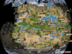
Wargaming on a Globe (Note: Graphic-intensive topic)
Posted: Wed Sep 03, 2008 2:49 pm
As most people know, or should know, flat maps are not an accurate representation of the surface of the earth. Generally speaking, the larger the area shown, the more distorted and inaccurate the map becomes, usually and especially near the edges, although it depends on which map projection is used.
Here is a typical Mercator projection map of the type often used to show the earth.

A couple of obvious problems with this: The increasingly gross distortions of the landmasses near the poles. Alaska, Northern Canada, Greenland, Scandinavia and Siberia are all much larger than they should be. Even more extreme is the size of Antarctica near the south pole.
Also, scrolling across the poles would not be possible if this map were used in a wargame, or at least wouldn't make any sense.
Nor do the areas near the poles come together as they actually do on a globe. In the above map, Siberia is many thousands of miles away from northern Canada, for example, when in reality it is much closer on a globe.
Using various modified flat-map projections doesn't solve these problems.
OK, hopefully most people here already knew all this.
The only accurate way of mapping the earth, or parts thereof, is to use a sphere/globe. (Yes, I know the earth is slightly egg-shaped, being a little wider at the equator than from pole to pole, but that is irrelevant and a perfect sphere would be just fine for the purpose of this discussion.)

Unfortunately, from everything I've been able to learn, it is impossible to impose a contiguous polygonal grid across the entirety of a globe. In other words, a globe cannot be completely overlaid with a contiguous hexagonal grid, or any other kind of grid, without resorting to some other polygonal shape in some area(s). A good example of this is a soccer ball.

Note that while the white polygons are hexagons, the black ones are pentagons.
The closest I've been able to find on the 'net that shows what I would consider an ideal global grid, is this graphic (source):

Sorry about the size of this, but I need to keep it big in order to point out the problems, which are two-fold.
First, while all the polygons in this grid are hexagons, the polygon I marked with a red X at the center is a pentagon. This is the point at which all the other polygons come together and due to the curvature of the sphere this apparently cannot be a hexagon.
Secondly, it is obvious that the sides of the hexagons nearest the center pentagon are distorted to various degrees, again presumably due to the curvature of the sphere. I don't know how such an irregular grid could be hard-coded into a computer wargame - it probably can't.
A similar situation presumably exists on the other side of this globe, at the south pole. Note that these areas of anomalies don't necessarily have to be at the poles, they could be located anywhere on the sphere, but the poles would probably be the best places, since those areas would presumbably be least used in a wargame.
Im presuming a lot, ain't I? But I think I'm making sense.
So what's the solution?
The most obvious solution is to not have a polygonal grid at all, but to simply depict areas, such as with the typical area maps of games like Empires in Arms, for example.
I myself am one of those people who is partial to having some kind of a grid, because area maps usually tend to have some areas that end up being more important than others, for various reasons, although I'll be the first to acknowledge that I have almost no experience with games that utilize area maps.
Another thing to consider - and maybe herein lies a solution - is that, when depicting a sphere/globe, only part of the earth would be visible to the player at any given time. No more than half the planet would be visible, even at the most extreme zoom-out level.
Let's imagine the ideal zoom level for my hypothetical wargame is similar to this graphic:

This happens to show a square grid, but a hexagonal grid could just as easily be used.
This then, might be the zoom level at which most game actions would take place, such as moving units, initiating and resolving combats, etc.
As the player scrolls around the map, the grid would stay stationary while the sphere beneath it moves. In this way, the polygonal anomalies shown on the large global map above might be avoided.
However, I'm not sure this actually solves the problem, because various locations on the map would still always have to be in the same locations in relation to one another and be the same distance apart, regardless of how the player scrolls the map.
That sounds a little confusing, so let me try to clarify.
In a conventional hex-grid wargame, a given location will always be in the same hex on the map. In fact, hexes are often numbered (AA07 and so forth). Likewise, any two locations will always be the same number of hexes apart from each other. For example, if city X is at hex AA01 and city Y is at hex AA05, it means there are 3 hexes between the cities, AA02, AA03 and AA04.
So, while hex numbering in my above system would probably be pointless, if not impossible, the relationship of any two points on the map, say between cities X and Y above, still need to be kept constant in terms of the overlaying hexagonal grid, no matter how the player rotates the underlying globe. That is, they always have to be four hexes apart and in the same direction of movment.
In order to accomplish this, the computer might be programmed to convert real-life distances into hex distances, so that the distance between say, Dallas and El Paso, which might be 300 miles, would be translated into say, 10 hexagons.
Well, I'm not sure if those last parts make sense to readers.
In any case, I'd like to see a strategy/wargame utilizing a rotatable globe as a map, even if it's an area map.
EDIT: Another possible solution might lie with a gridless pixel-to-pixel system, such as I understand is used in games like Conquest of the Aegean, which I haven't played.
Here is a typical Mercator projection map of the type often used to show the earth.
A couple of obvious problems with this: The increasingly gross distortions of the landmasses near the poles. Alaska, Northern Canada, Greenland, Scandinavia and Siberia are all much larger than they should be. Even more extreme is the size of Antarctica near the south pole.
Also, scrolling across the poles would not be possible if this map were used in a wargame, or at least wouldn't make any sense.
Nor do the areas near the poles come together as they actually do on a globe. In the above map, Siberia is many thousands of miles away from northern Canada, for example, when in reality it is much closer on a globe.
Using various modified flat-map projections doesn't solve these problems.
OK, hopefully most people here already knew all this.
The only accurate way of mapping the earth, or parts thereof, is to use a sphere/globe. (Yes, I know the earth is slightly egg-shaped, being a little wider at the equator than from pole to pole, but that is irrelevant and a perfect sphere would be just fine for the purpose of this discussion.)
Unfortunately, from everything I've been able to learn, it is impossible to impose a contiguous polygonal grid across the entirety of a globe. In other words, a globe cannot be completely overlaid with a contiguous hexagonal grid, or any other kind of grid, without resorting to some other polygonal shape in some area(s). A good example of this is a soccer ball.
Note that while the white polygons are hexagons, the black ones are pentagons.
The closest I've been able to find on the 'net that shows what I would consider an ideal global grid, is this graphic (source):
Sorry about the size of this, but I need to keep it big in order to point out the problems, which are two-fold.
First, while all the polygons in this grid are hexagons, the polygon I marked with a red X at the center is a pentagon. This is the point at which all the other polygons come together and due to the curvature of the sphere this apparently cannot be a hexagon.
Secondly, it is obvious that the sides of the hexagons nearest the center pentagon are distorted to various degrees, again presumably due to the curvature of the sphere. I don't know how such an irregular grid could be hard-coded into a computer wargame - it probably can't.
A similar situation presumably exists on the other side of this globe, at the south pole. Note that these areas of anomalies don't necessarily have to be at the poles, they could be located anywhere on the sphere, but the poles would probably be the best places, since those areas would presumbably be least used in a wargame.
Im presuming a lot, ain't I? But I think I'm making sense.
So what's the solution?
The most obvious solution is to not have a polygonal grid at all, but to simply depict areas, such as with the typical area maps of games like Empires in Arms, for example.
I myself am one of those people who is partial to having some kind of a grid, because area maps usually tend to have some areas that end up being more important than others, for various reasons, although I'll be the first to acknowledge that I have almost no experience with games that utilize area maps.
Another thing to consider - and maybe herein lies a solution - is that, when depicting a sphere/globe, only part of the earth would be visible to the player at any given time. No more than half the planet would be visible, even at the most extreme zoom-out level.
Let's imagine the ideal zoom level for my hypothetical wargame is similar to this graphic:
This happens to show a square grid, but a hexagonal grid could just as easily be used.
This then, might be the zoom level at which most game actions would take place, such as moving units, initiating and resolving combats, etc.
As the player scrolls around the map, the grid would stay stationary while the sphere beneath it moves. In this way, the polygonal anomalies shown on the large global map above might be avoided.
However, I'm not sure this actually solves the problem, because various locations on the map would still always have to be in the same locations in relation to one another and be the same distance apart, regardless of how the player scrolls the map.
That sounds a little confusing, so let me try to clarify.
In a conventional hex-grid wargame, a given location will always be in the same hex on the map. In fact, hexes are often numbered (AA07 and so forth). Likewise, any two locations will always be the same number of hexes apart from each other. For example, if city X is at hex AA01 and city Y is at hex AA05, it means there are 3 hexes between the cities, AA02, AA03 and AA04.
So, while hex numbering in my above system would probably be pointless, if not impossible, the relationship of any two points on the map, say between cities X and Y above, still need to be kept constant in terms of the overlaying hexagonal grid, no matter how the player rotates the underlying globe. That is, they always have to be four hexes apart and in the same direction of movment.
In order to accomplish this, the computer might be programmed to convert real-life distances into hex distances, so that the distance between say, Dallas and El Paso, which might be 300 miles, would be translated into say, 10 hexagons.
Well, I'm not sure if those last parts make sense to readers.
In any case, I'd like to see a strategy/wargame utilizing a rotatable globe as a map, even if it's an area map.
EDIT: Another possible solution might lie with a gridless pixel-to-pixel system, such as I understand is used in games like Conquest of the Aegean, which I haven't played.