Page 1 of 1
How do you work with 2048 pixel map?
Posted: Sat Dec 15, 2018 8:00 pm
by exsonic01
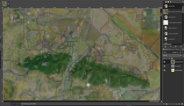
Terrain bmp layer + 2048 pixel Satellite layer with slight transparency from GIMP.
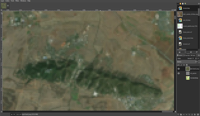
2048 pixel Satellite layer only. AB map editor preview (pressing T) looks like this as well. If I use higher pixel, it looks a bit better but still not that useful for detail work.
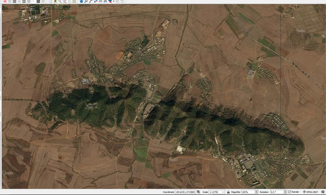
This is what the region really looks like from QGIS.
As you can see, from 2048 pixel, a lot of details are ignored. Dirt road networks are gone, and towns are pixelized so hard to tell which one is 2x1 or 1x2. Do I need to ignore all those narrow dirt road networks and all those details? I wish to depict the details but this consumes too much time and hard to check.
So far I directly draw from AB map editor, checking 6144px or 4096px preview (satellite map) by pressing T. But this takes too much time and hard to check those details.

This is what terrain bmp looks like from GIMP.
22sec and CCIP once told me that I need to draw base terrain.bmp from GIMP to work in AB map editor, and CCIP draw me one. May I ask how can I draw that base terrain.bmp from GIMP, so that I can work more efficiently from AB map editor? Do you guys would ignore those dirt roads and detail description of towns (which can be shown from high quality satellite), if it were you?
RE: How do you work with 2048 pixel map?
Posted: Mon Dec 17, 2018 2:59 am
by CCIP-subsim
Here's a possible thought:
If you were used to editing with the resolution of a 8192x8192 "preview" map, and the limitation seems to be the total resolution of the preview (2048px) - how about splitting the map up into 512x512 sized pieces with a 2048x2048 preview file for each? That way you get the same resolution - and it should be relatively easy to split up the terrain/height maps and then re-connect them in Gimp once you're ready.
RE: How do you work with 2048 pixel map?
Posted: Mon Dec 17, 2018 3:16 am
by exsonic01
ORIGINAL: CCIP-subsim
Here's a possible thought:
If you were used to editing with the resolution of a 8192x8192 "preview" map, and the limitation seems to be the total resolution of the preview (2048px) - how about splitting the map up into 512x512 sized pieces with a 2048x2048 preview file for each? That way you get the same resolution - and it should be relatively easy to split up the terrain/height maps and then re-connect them in Gimp once you're ready.
Thanks for your attention for this matter, could you be give me more detail?
Is this means:
1) From terrain.bmp map, split the 512px x 512px of area that I'm working on now. This is 15360x15360 m2 size.
2) From 8192px x 8192px satellite, split the same region of 2048px x 2048px, this is also 15360x15360 m2 size.
3) Load from AB map editor and work.
Is this correct?
Also, could you let me know briefly what trick from Photoshop or GIMP, which would make the satellite map image more 'sharp'? I wish to make the color from satellite map more distinguishable, so that I can see the color difference more clearly. But I'm not that pro at GIMP or Photoshop.
Thank you!!
RE: How do you work with 2048 pixel map?
Posted: Mon Dec 17, 2018 1:36 pm
by exsonic01
IT WORKED!!!!!!!!!!!!!!!! Along with preview and terrain.bmp, Height.bmp should be cropped as well.


Before


After
I even prepared 16384px x 16384px regional map, and cropped 4092px x 4092px, which gave me high quality 15km x 15km preview.
Thank you so much!
RE: How do you work with 2048 pixel map?
Posted: Mon Dec 17, 2018 4:32 pm
by CCIP-subsim
Glad to hear that [:)]
You might already know this, but using the grid in Gimp can be really helpful if you're splitting up the map/preview into equal-sized pieces and then have to reassemble them. Just set the grid to the size you need (Image => Grid Settings), i.e. 512 or 256 or 2048 pixels, and then use it (View => Show Grid / Snap to Grid) for selecting/copying/pasting/resizing the pieces you need. Makes the whole process a bit more painless!
RE: How do you work with 2048 pixel map?
Posted: Mon Dec 17, 2018 4:47 pm
by exsonic01
ORIGINAL: CCIP-subsim
Glad to hear that [:)]
You might already know this, but using the grid in Gimp can be really helpful if you're splitting up the map/preview into equal-sized pieces and then have to reassemble them. Just set the grid to the size you need (Image => Grid Settings), i.e. 512 or 256 or 2048 pixels, and then use it (View => Show Grid / Snap to Grid) for selecting/copying/pasting/resizing the pieces you need. Makes the whole process a bit more painless!
Thank you for your advice. Do you increase contrast for your satellite map during map work? Or are there any other methods to make colors more distinguished?
RE: How do you work with 2048 pixel map?
Posted: Tue Dec 18, 2018 7:43 pm
by CCIP-subsim
There's a few ways - the best tool (which takes a bit to wrap your head around, but is way better than other methods) is using curves.
Here's one Gimp tutorial on using curves, you can easily find other similar ones though if it doesn't quite make sense:
https://www.youtube.com/watch?v=RCoOyqt9qa8