Page 1 of 1
Fixing Terrain Height
Posted: Fri Oct 02, 2026 1:28 am
by FifthDomain
Good Morning
Build: Steam 1900.20
Is there a way to fix terrain height on the map there are places underwater that should be land and land that should be water. (Example Lerwick in Shetland most of it is at -20m).
Also the borders and coastlines overlay is out of line in this area. (Easiest to view using Sentinel 2 overlay)
Thanks in advance for any advance or suggestions.
Re: Fixing Terrain Height
Posted: Fri Oct 02, 2026 12:44 pm
by TempestII
Yes, CEZs work well for this purpose. They give you the option to raise the height and change the terrain type.
Re: Fixing Terrain Height
Posted: Fri Oct 02, 2026 5:08 pm
by FifthDomain
TempestII wrote: Fri Oct 02, 2026 12:44 pm
Yes, CEZs work well for this purpose. They give you the option to raise the height and change the terrain type.
I tried with a CEZ the terrain just stayed the same -20m. I tried the tick box and setting it to 9m but it just stayed it original height and i couldn't place the buildings on it still. The box also kept deselecting.
Re: Fixing Terrain Height
Posted: Fri Oct 02, 2026 5:25 pm
by Nikel
Not sure there is a bug. But it worked this way (B1892).
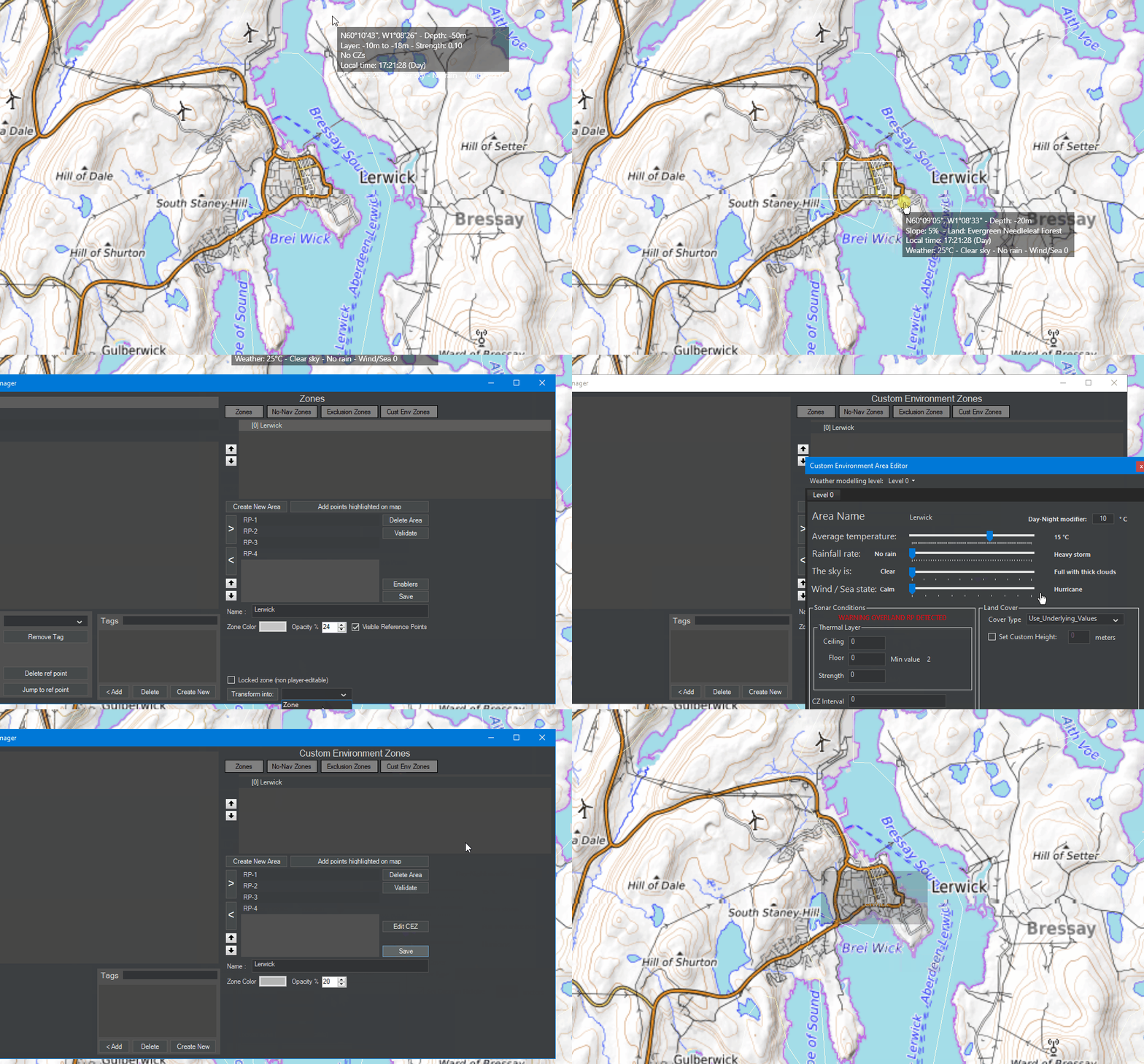
- CEZ.gif (3.14 MiB) Viewed 285 times
Re: Fixing Terrain Height
Posted: Fri Oct 02, 2026 5:59 pm
by FifthDomain
Nikel wrote: Fri Oct 02, 2026 5:25 pm
Not sure there is a bug. But it worked this way (B1892).
CEZ.gif
Ok that worked, thank you very much, I don't know why it didn't work yesterday, I think maybe i didn't press the save button at the same point in the sequence, but your method has worked.
But what i will say is the area that is -20m says it is Land: Evergreen Needleleaf Forest so something is definitely wrong height wise it's not just here either it's all over the map.
Re: Fixing Terrain Height
Posted: Wed Oct 07, 2026 12:54 pm
by Knightpawn
FifthDomain wrote: Fri Oct 02, 2026 1:28 am
Good Morning
Build: Steam 1900.20
Is there a way to fix terrain height on the map there are places underwater that should be land and land that should be water. (Example Lerwick in Shetland most of it is at -20m).
Also the borders and coastlines overlay is out of line in this area. (Easiest to view using Sentinel 2 overlay)
Thanks in advance for any advance or suggestions.
There is corollary of that problem that is highly consequential: Facilities placed on below 0 ft (-xx ft) terrain - which is within the land borders on the map - cannot become valid targets for some air weapons. I say "some" because I have not tested all. But this clearly was the case I a scenario in the Baltic sea where many such points exist