Panzer War Miniature Rules

Panzer Command: Ostfront is the latest in a new series of 3D turn-based tactical wargames which include single battles, multi-battle operations and full war campaigns with realistic units, tactics and terrain and an informative and practical interface. Including a full Map Editor, 60+ Scenarios, 10 Campaigns and a very long list of improvements, this is the ultimate Panzer Command release for the Eastern Front!

Moderator: rickier65

rickier65
Posts: 14252
Joined: Thu Apr 20, 2000 8:00 am

RE: Panzer War Miniature Rules

Post by rickier65 »

ORIGINAL: Ratzki

.....
Oh, just FYI, I am getting a API key needs to be fixed in the Mmaker. I found my way around it but not that straight forward, should others have the same issue.

Stridor posted a fix for this here: fb.asp?m=3284674

I will upload the edited file as a mod. I already have it included in things for the next time we do a patch.

Thanks
Rick
Ratzki
Posts: 580
Joined: Sun Aug 17, 2008 9:32 pm
Location: Chilliwack, British Columbia

RE: Panzer War Miniature Rules

Post by Ratzki »

I have found it easier to load the height map into paint.net and edit from there. Followed Mobius' advice and played with the contrast until I got it where I wanted. Easier to deal with I think. I have not attempted to flesh out a stream yet. May give this a go some time today. Just a little more versitile using paint.net the staying inside MMaker. Jury still out though.
rickier65
Posts: 14252
Joined: Thu Apr 20, 2000 8:00 am

RE: Panzer War Miniature Rules

Post by rickier65 »

ORIGINAL: Ratzki

I have found it easier to load the height map into paint.net and edit from there. Followed Mobius' advice and played with the contrast until I got it where I wanted. Easier to deal with I think. I have not attempted to flesh out a stream yet. May give this a go some time today. Just a little more versitile using paint.net the staying inside MMaker. Jury still out though.

Streams can get tricky, takes a bit of playing to get them right sometimes. Let us know how it turns out.

Thanks
rick
Ratzki
Posts: 580
Joined: Sun Aug 17, 2008 9:32 pm
Location: Chilliwack, British Columbia

RE: Panzer War Miniature Rules

Post by Ratzki »

Still working on the best way to come up with streams. I am still leaning towards using a program like paint.net or what-have-you over trying to play with the height map within the editor. Been adjusting the contrast and colour in paint and now can see the different grey scales with ease.
I have had a little issue pop up with the editor as of late and can't seem to figure it out. I am getting a crash every time that i try to edit the depth of the water. Getting an unable to access memory blah... blah and then the editor kicks me out. Now everything else works and I do not know when this might have started as I have just been avoiding the water/stream making up to this point. I am at work at the moment so do not know the exact statement as to what memory fault is being affected. Any ideas?
rickier65
Posts: 14252
Joined: Thu Apr 20, 2000 8:00 am

RE: Panzer War Miniature Rules

Post by rickier65 »


I'm curious as to how your gray scale height map work is coming along.

When I worked with streams, I had the most luck by roughing in the stream with the tools. then locking the stream work area to deepen, then some more locking to smooth the banks. but making sure the brush size was set to small size when smoothing so that the smoothing worked more 'locally'. When you do a smooth operation, it looks an a "cell" area around the point being smoothed. if brush size is set to large then the smoothing is based on a larger area, setting it to small makes the smooth operation only look at adjacent points.

When you say the MM editor had CTD when you were adjusting the water depth, you mean when you were setting the depth of shallow vs deep?

I'll check a map and see if I can replicate.

Thanks
Rick
Ratzki
Posts: 580
Joined: Sun Aug 17, 2008 9:32 pm
Location: Chilliwack, British Columbia

RE: Panzer War Miniature Rules

Post by Ratzki »

Ok, what I have been trying is grabbing the greyscale height map image in Paint.net. Then adjusting so I can see the fine shade differences using contrast and colour adjustments. Now I can zoom in to a level with more control then with MMaker. I select the depth that i want the stream at and adjust the brush width to where I want it. Copy the geryscale colour that will be appropriate depth and paint away. I then have a 256 greyscale pallet open and adjust the banks in intervals of about ten shades higher then the stream depth with a fairly wide brush and paint the banks. I just keep on upping the banks in this interval until I get the height I want that starts to fit the terrain. Because I am able to get a better zoom level and see more precisely the shade differences, I can almost recreate a topo type map with these brush strokes and layers. The layers let me adjust the width of the contours without all the fiddling around. Now I am just kind of following the course greyscale produced by MMaker, but am getting a topo type effect that is pretty close to the generated height map but actually makes sense and is easier to see and manipulate outside of MMaker. This way I potentially get 25 greyscale height variants as I go up 10 shades at a time and it is easier to see and easier to produce. After I flatten and save I am good to go with the height map in MMaker, I lock down the stream/water level and smooth away.
Is it faster?... I do not know, but I do know that the amount of cussing and threatening my computer has gone way down. I do not make nearly as many mistakes or readjustments as I do when just using MMaker.
User avatar
Mobius
Posts: 10339
Joined: Thu Jun 29, 2006 10:13 pm
Location: California
Contact:

RE: Panzer War Miniature Rules

Post by Mobius »

Well, if you want to see what I had to go through to make a map before Stridor added the gray scale to MM, here are some of the stages of the Voin map.
1. I made a screen image from the Google map of the area. Then I used the height tool a wrote the elevations on the map.
2. I made a layer on the image and drew contour lines per the adhoc gray scale on the right.
Then I filled each contour area with a color.
Then I filled each color area with a gray shade.

Then this large gray scale image was blurred a bit, trimmed and reduced to 65x65 pixels.


Image
Attachments
makingvoin.jpg
makingvoin.jpg (357.25 KiB) Viewed 264 times
All your Tanks are Belong to us!
panzer
Ratzki
Posts: 580
Joined: Sun Aug 17, 2008 9:32 pm
Location: Chilliwack, British Columbia

RE: Panzer War Miniature Rules

Post by Ratzki »

I feel that the major issue with MMaker is the greyscale. I love MMaker for the most part, but elevation editing with colour would have been the cat's meow. Just so much easier to see.
The rest of MMaker is great, there are a few issues present but nothing that can't be worked with.
rickier65
Posts: 14252
Joined: Thu Apr 20, 2000 8:00 am

RE: Panzer War Miniature Rules

Post by rickier65 »


Post how your map turns out. And upload it if you can. I'm curious to see the result.

thanks
rick
Ratzki
Posts: 580
Joined: Sun Aug 17, 2008 9:32 pm
Location: Chilliwack, British Columbia

RE: Panzer War Miniature Rules

Post by Ratzki »

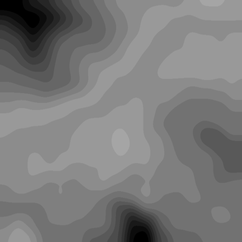
This is what I get after some tinkering in paint.net. When this is loaded into MMaker it gets pixalated but no problem as I have already finished playing with the greyscale. I have the terrain map as a layer so that I can line up any features on the map to the height map. Way easier to see and make sense of. Now as stated, my elevations are rough as I am using shades that are about 10 notches lighter with each elevation change. MMaker will pixelate it and I will be able to smooth inside MMaker, but this is all that needs to be done.
Image
Ratzki
Posts: 580
Joined: Sun Aug 17, 2008 9:32 pm
Location: Chilliwack, British Columbia

RE: Panzer War Miniature Rules

Post by Ratzki »

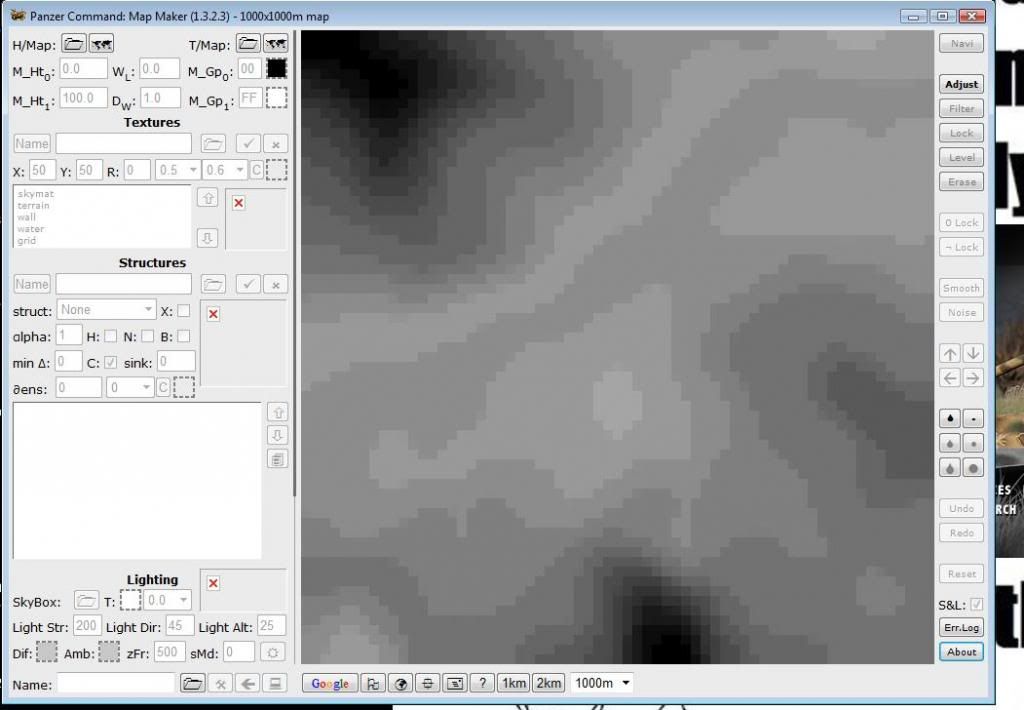
This is the same heightmap in MMaker.
Image
User avatar
Mobius
Posts: 10339
Joined: Thu Jun 29, 2006 10:13 pm
Location: California
Contact:

RE: Panzer War Miniature Rules

Post by Mobius »

You could blur it a bit before giving it to MM so the levels won't appear stepped.
All your Tanks are Belong to us!
panzer
rickier65
Posts: 14252
Joined: Thu Apr 20, 2000 8:00 am

RE: Panzer War Miniature Rules

Post by rickier65 »


Ratzki,

Do you do some smoothing passes in MM then?

Would it be worth creating a template with some preset greyscale - elev settings for others to use?

I'm anxious to see how it turns out.

Thanks
Rick
rickier65
Posts: 14252
Joined: Thu Apr 20, 2000 8:00 am

RE: Panzer War Miniature Rules

Post by rickier65 »


Also, if I'm looking at it correctly, it looks like you have both FF and 00 used. I think I would go with leaving some shades at both ends of the scale unused so that you have some flexibility in going higher or deeper if needed.

Though maybe that isn't necessary using this method.

Thanks
Rick
Ratzki
Posts: 580
Joined: Sun Aug 17, 2008 9:32 pm
Location: Chilliwack, British Columbia

RE: Panzer War Miniature Rules

Post by Ratzki »

Yes I have been smoothing in MMaker as a final step. I did not think about blurring 1st as Mobius stated.
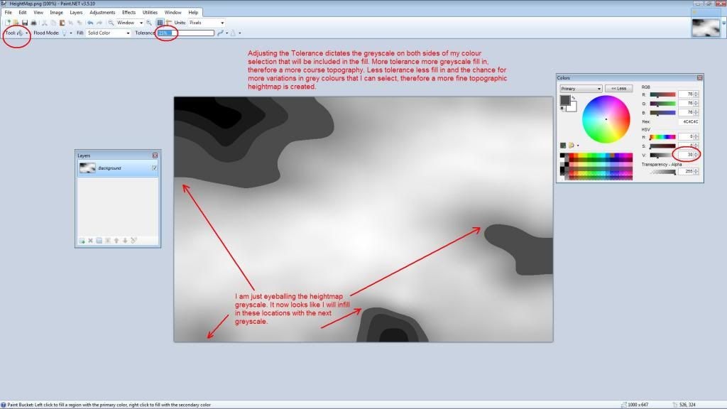
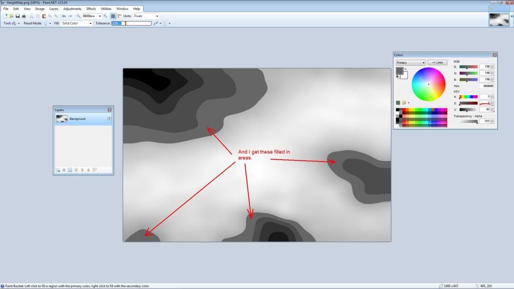
I have been able to cut the time to turn out a height map though. What I was just playing with is the "paint bucket" with tolerance set to 25%. Now when I select a greyscale and apply the "paint bucket" I get a colour fill of the grey that follows the selected location colour with ableedout in each direction determined by the tolerance set.
Image

And after the next infill is completed with the new greyscale colour selected.

Image
Ratzki
Posts: 580
Joined: Sun Aug 17, 2008 9:32 pm
Location: Chilliwack, British Columbia

RE: Panzer War Miniature Rules

Post by Ratzki »

As you can see, A person could produce a topo type greyscale image in a very short time like this. It can be as rough or fine as you want and contain as many greyscale colours as you need to get the effect that you want. The more greys that you use the harder it will be to see the differing greys on screen. I admit that I am not producing an absolutly accurate height map, but it is getting faster and easier to produce a height map like this and the "topographic" heightmap that I get is easy to read and see the lay of the land. Maybe MMaker was/is too accurate. If cut back to 20-30 greyscale steps, it might be able to produce this effect on it's own.
Same seems to be true with the terrain map image. MMaker might be just too darn accrate. Been playing with the terrain the same way. Not quite the same level of control as with the height map but better. I can generate a terrain colour map or at least a good part of it in paint.net using the infill and some brushing right off the google earth arial photo. I know this is not new news but what I am getting at is that MMaker might be able to be tweeked where it can just tone down it's accuracy and things might get a whole lot better.
Ratzki
Posts: 580
Joined: Sun Aug 17, 2008 9:32 pm
Location: Chilliwack, British Columbia

RE: Panzer War Miniature Rules

Post by Ratzki »

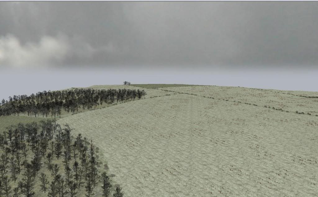
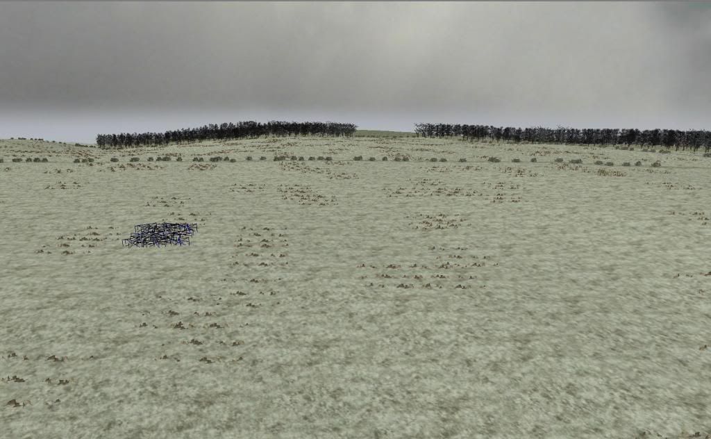
This is the finished product, NE of Kharkov. I just autogened some trees ect. for a quick fill.
Image
Another image.
Image
Ratzki
Posts: 580
Joined: Sun Aug 17, 2008 9:32 pm
Location: Chilliwack, British Columbia

RE: Panzer War Miniature Rules

Post by Ratzki »

The link to my dropbox file of the map.
https://dl.dropboxusercontent.com/u/30777768/map.zip
rickier65
Posts: 14252
Joined: Thu Apr 20, 2000 8:00 am

RE: Panzer War Miniature Rules

Post by rickier65 »


Ratzki,

Thanks for uploading, I've downloaded and I"ll take a look later today. I've used paint.net for terrain map, but not for the heightmap. I'll have to give it a try.

Thanks!
Rick
Ratzki
Posts: 580
Joined: Sun Aug 17, 2008 9:32 pm
Location: Chilliwack, British Columbia

RE: Panzer War Miniature Rules

Post by Ratzki »

How did the height map experiment go for you?
Post Reply

Return to “Panzer Command: Ostfront”