Prepare yourself for a wargaming tour-de-force! Conquest of the Aegean is the next generation of the award-winning and revolutionary Airborne Assault series and it takes brigade to corps-level warfare to a whole new level. Realism and accuracy are the watchwords as this pausable continuous time design allows you to command at any echelon, with smart AI subordinates and an incredibly challenging AI.
This file replaces the one posted previously. I corrected a few errors and changed the images from bmps to pngs to reduce the memory footprint when using it.
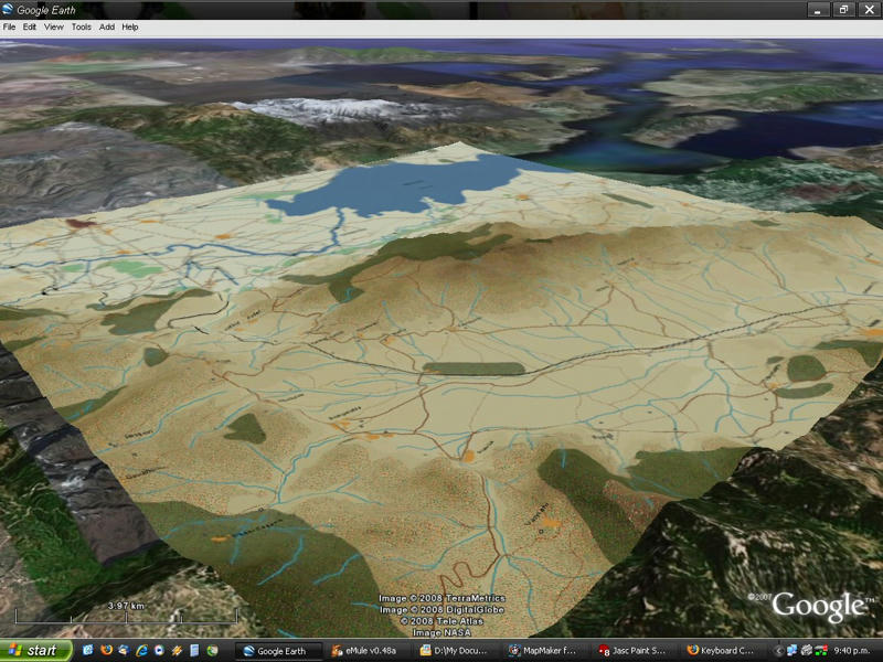
Just unzip the KMZ file to any where, and double-click on it. Google Earth should open and there will be a folder called COTA maps in your Temporary Places folder.If you click on a map link you'll also see what scenarios use that map.
Very nicely done. I must have played this scenario at least a dozen times trying time, and time again to get a decisive victory. It's very interesting to see the terrain in 3D.
I've been having a lot of fun doing this so I've decided to do all the stock maps,once I'm done I'll create a KMZ file and if anyone wants it, give me a shout. [:)]
Gen. Montgomery: "Your men don't salute much." Gen. Freyberg: "Well, if you wave at them they'll usually wave back."
Can I just say wow. This is exactly what I have been wanting for absolutely ages. Its my biggest problem with the whole Airborne Assault series. No matter how hard I try I can't visualise the terrain nor make any instinctive moves based on the terrain. I am always spending what I feel is too long messing about with the LOS tools. If you could post the links or downloads that would be fantastic.
A 3D map is the one thing I think would enhance Airborne Assault series immensely.
I agree. I always have a hard time visualizing the maps in 3D. Thanks.
While not quite as stupendous as these 3D shots, there has been some tweaking to the maps that increases the intensity of color and heightens the contrast between contours. I have found the latest beta testing with those maps goes a long way toward alleviating the problem and gives me a much better sense of the heights and valleys.
Now didn't we have something similar in the past ?
[edited after a quick search] Here we are : COTA Preview In Google Earth
Same tool. A different approach.
JeF.
Thanks [:)] I'd actually forgotten about that one.I got the inspiration for this one from the Panzer Command:Kharkov GE preview.
What I'm doing is not really that hard to do, just time consuming.I take screenshots of the maps at the 16 metres per pixel resolution, join them together in Paintshop Pro,and save as a bmp.I create a new overlay in GE,load the bmp, and then it's just a case of trying to match the terrain.Some of the maps are bang on but some are a bit off (Different projections,I guess).
I've just loaded the two COTA kmz files together in Google Earth and it looks really impressive [:)].
Gen. Montgomery: "Your men don't salute much." Gen. Freyberg: "Well, if you wave at them they'll usually wave back."
I've just updated the first post with the link to the updated kmz file. It's now complete, the only maps I haven't done are ones that are parts of a bigger map and the North Africa maps. Some of the maps look pretty spectacular in 3-D, especially the ones in the mountains.
Gen. Montgomery: "Your men don't salute much." Gen. Freyberg: "Well, if you wave at them they'll usually wave back."
Big issue for me...visualising the lay of the land. I know all has been done that can be done without going 3D...but as a gamer, I'd love to see it move to 3D.
There's a program on British TV...20th Century Battlefields I think it's called. Shows battles in 3D using CGI...little blue armies and red armies and 3D terrain. It really transforms what the narrator is trying to tell you. I'm not advocating 3D graphics...I like the NATO symbology. But 3D maps? I wait for the day.
Personally, it would increase my immersion level more than anyone could believe.
I mean, just look at the Thermopylae map...I don't know about anyone else...but the map just never conveyed to me the limit on manouvreability as the 3D map does. Using the 3D map, I can immediately see where I would like to place spotters, arty etc. I can also see, at a glance, the main route and I was never able to visualise the pass like that.
You know, thinking about it, just as an aside, if it wasn't possible to introduce 3D maps into the game, would it be possible to spice up your briefings? Have a 3D map showing the lay of the land and objectives (would need to be able to reference it whilst in game to refresh your memory). also, chuck in a couple of powerpoint/flash briefings (I don't know what tech is available for an "interactive" briefing...or at least a "video" briefing).
But I digress (for a change). Very nice. I'd be interested in seeing them all, or knowing how to do it, so I can view the 3D map whilst playiong (alt-tabbing until they include them!!)
very nice. [&o]