Schluchtern to Gelnhausen January 1961

Post new mods and scenarios here.

Moderator: MOD_Flashpoint

Post Reply
WABAC
Posts: 496
Joined: Sat Jan 25, 2014 6:40 pm
Location: Where Satan buys hinges

Schluchtern to Gelnhausen January 1961

Post by WABAC »

I can't do the fancy graphics. But I figure some here will be interested in the map anyway -- especially before it gets covered with trees.

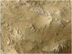
Since the scenario takes place in January I have not added any of the minor east-west roads. Given the cut nature of the terrain I suspect there will be a lot of obstacles where the terrain jumps up from the valleys at an angle that would defeat most tanks of any era.

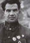
Given the protracted nature of the buildup I am imagining elements of a category B, 1959 pattern, Soviet MRD versus a straight leg BG of the 8th ID providing their credentials. In the Pentomic divisions transportation companies were a divisional asset. At the moment I am thinking of the 1/18th, under COL Glover S. Johns, recently rotated out of Berlin for a little bit of a campout in this fictional timeline.

I hope to make faster progress with this scenario. The latest iterations of the engine are much kinder to towed artillery, of which, the Soviets will have a lot. [8D] And I have a little time off before baseball season.


Image
Attachments
Salmunster.jpg
Salmunster.jpg (822.87 KiB) Viewed 222 times
WABAC
Posts: 496
Joined: Sat Jan 25, 2014 6:40 pm
Location: Where Satan buys hinges

RE: Schluchtern to Gelnhausen January 1961

Post by WABAC »

Crikey. That's a honking big file. Obviously I have some scaling to do [X(]

After I do some cooking. [8D]

Happy holidays y'all. [:)]
WABAC
Posts: 496
Joined: Sat Jan 25, 2014 6:40 pm
Location: Where Satan buys hinges

RE: Schluchtern to Gelnhausen January 1961

Post by WABAC »

Anyone have any opinions on whether the Kinzig is enough of a river to put on the map? And at roughly what point does it become big enough?

I have nothing better to do today than eat leftovers and work on my map. [:)]
User avatar
WildCatNL
Posts: 837
Joined: Fri Mar 27, 2009 5:21 pm
Location: Eindhoven, the Netherlands

RE: Schluchtern to Gelnhausen January 1961

Post by WildCatNL »

ORIGINAL: WABAC

Anyone have any opinions on whether the Kinzig is enough of a river to put on the map? And at roughly what point does it become big enough?

I have nothing better to do today than eat leftovers and work on my map. [:)]

I'd put it on the map as a stream, not as a river. My rules of thumb:
- if it cannot be spanned by a single bridge-layer (~18m), it is a river
- if the satellite maps don't show proper bridges across it, it is a ditch and not a stream

The Kinzig has clear bridges, but is narrow enough in most spots for a single MTU-72 put a bridge across.

William
William
On Target Simulations LLC
WABAC
Posts: 496
Joined: Sat Jan 25, 2014 6:40 pm
Location: Where Satan buys hinges

RE: Schluchtern to Gelnhausen January 1961

Post by WABAC »

ORIGINAL: W1ll14m
ORIGINAL: WABAC

Anyone have any opinions on whether the Kinzig is enough of a river to put on the map? And at roughly what point does it become big enough?

I have nothing better to do today than eat leftovers and work on my map. [:)]

I'd put it on the map as a stream, not as a river. My rules of thumb:
- if it cannot be spanned by a single bridge-layer (~18m), it is a river
- if the satellite maps don't show proper bridges across it, it is a ditch and not a stream

The Kinzig has clear bridges, but is narrow enough in most spots for a single MTU-72 put a bridge across.

William

I like that rule of thumb. Thank you. Looks like the Kinzig is bridged all the way to Schluchtern. And I shall check out some of the feeders accordingly.

Judging by the surrounding terrain my guess is the streams in that area could get a little trickier to bridge in the spring time.
WABAC
Posts: 496
Joined: Sat Jan 25, 2014 6:40 pm
Location: Where Satan buys hinges

RE: Schluchtern to Gelnhausen January 1961

Post by WABAC »

I am re-reading the map guide and the game only features rivers. So no blue lines on this map.
User avatar
Mad Russian
Posts: 13255
Joined: Sat Mar 15, 2008 9:29 pm
Location: Texas

RE: Schluchtern to Gelnhausen January 1961

Post by Mad Russian »

Put the road above the trees. Or the trees below the road. Either way. That will make less work for you than sculpting them.

Good Hunting.

MR
The most expensive thing in the world is free time.

Founder of HSG scenario design group for Combat Mission.
Panzer Command Ostfront Development Team.
Flashpoint Campaigns: Red Storm Development Team.
WABAC
Posts: 496
Joined: Sat Jan 25, 2014 6:40 pm
Location: Where Satan buys hinges

RE: Schluchtern to Gelnhausen January 1961

Post by WABAC »

ORIGINAL: Mad Russian

Put the road above the trees. Or the trees below the road. Either way. That will make less work for you than sculpting them.

Good Hunting.

MR

That flew right over my head. When you have a brain like mine it's best to get used to working harder.[:D]
User avatar
WildCatNL
Posts: 837
Joined: Fri Mar 27, 2009 5:21 pm
Location: Eindhoven, the Netherlands

RE: Schluchtern to Gelnhausen January 1961

Post by WildCatNL »

ORIGINAL: WABAC

I am re-reading the map guide and the game only features rivers. So no blue lines on this map.

Maybe I'm confusing you with different terminology than the Map Values manual uses (on page 13). I tend to call the blue lines streams, and full size hexes either lakes or rivers.

I recommend to put the Kinzig on the map as a blue line, not as a chain of full size "Lake" hex (which the manual doesn't discuss for rivers, but which the game map use for major rivers such as the Rhine, Main, Weser). The Kinzig definitely is tactically significant.

William
William
On Target Simulations LLC
WABAC
Posts: 496
Joined: Sat Jan 25, 2014 6:40 pm
Location: Where Satan buys hinges

RE: Schluchtern to Gelnhausen January 1961

Post by WABAC »

OK. That rings a bell. And there are some small lakes on the map I have to deal with anyway.

Thank you.
WABAC
Posts: 496
Joined: Sat Jan 25, 2014 6:40 pm
Location: Where Satan buys hinges

RE: Schluchtern to Gelnhausen January 1961

Post by WABAC »

This is the map at half size. I am now ready to start editing the values. I have put in about ten hours since the first map up above. There are probably faster way to do this, but I'm having fun.

Image
Attachments
Gelnhausen..hluctern.jpg
Gelnhausen..hluctern.jpg (1002.94 KiB) Viewed 220 times
User avatar
Mad Russian
Posts: 13255
Joined: Sat Mar 15, 2008 9:29 pm
Location: Texas

RE: Schluchtern to Gelnhausen January 1961

Post by Mad Russian »

What size is that map?

Good Hunting.

MR
The most expensive thing in the world is free time.

Founder of HSG scenario design group for Combat Mission.
Panzer Command Ostfront Development Team.
Flashpoint Campaigns: Red Storm Development Team.
WABAC
Posts: 496
Joined: Sat Jan 25, 2014 6:40 pm
Location: Where Satan buys hinges

RE: Schluchtern to Gelnhausen January 1961

Post by WABAC »

ORIGINAL: Mad Russian

What size is that map?

Good Hunting.

MR

Half game size.
WABAC
Posts: 496
Joined: Sat Jan 25, 2014 6:40 pm
Location: Where Satan buys hinges

RE: Schluchtern to Gelnhausen January 1961

Post by WABAC »

The map has been uploaded to the OTS web site.
User avatar
CapnDarwin
Posts: 9528
Joined: Sat Feb 12, 2005 3:34 pm
Location: Newark, OH
Contact:

RE: Schluchtern to Gelnhausen January 1961

Post by CapnDarwin »

Thanks for posting the game!
OTS is looking forward to Southern Storm getting released!

Cap'n Darwin aka Jim Snyder
On Target Simulations LTD
WABAC
Posts: 496
Joined: Sat Jan 25, 2014 6:40 pm
Location: Where Satan buys hinges

RE: Schluchtern to Gelnhausen January 1961

Post by WABAC »

Have a while to go on the game part. [8D] But the US OOB is set and on the map. And I now have the Soviet force in mind -- 37th Guards Tank Division. But it will require a little work on the Soviet forces spread sheet to get right.

harry_vdk
Posts: 338
Joined: Tue Jun 10, 2014 11:41 am
Location: Drachten

RE: Schluchtern to Gelnhausen January 1961

Post by harry_vdk »

Hi,

I was busy with testing my OtsFp9Tools and saw that only your white roads have a road mapvalue.

Your GelnhausenToSchluctern.fp9 (from the ots site) have a date/time of 31-12-2014 14:27


Image
Attachments
Gelnhausen..hluctern.jpg
Gelnhausen..hluctern.jpg (378.65 KiB) Viewed 217 times
WABAC
Posts: 496
Joined: Sat Jan 25, 2014 6:40 pm
Location: Where Satan buys hinges

RE: Schluchtern to Gelnhausen January 1961

Post by WABAC »

Thank you for catching that. [:)]

Not sure what happened besides too much time between sessions working on the project.
User avatar
cbelva
Posts: 2217
Joined: Sat Mar 26, 2005 8:11 pm
Location: Nevada USA

RE: Schluchtern to Gelnhausen January 1961

Post by cbelva »

Hey Harry,

I downloaded and took a look at your map. Good work, I really like it. I have created several using Hexdraw myself. I do have one suggestion. You can set the forest overlays to a lower level and they won't cover up your trees. There are three overlays levels, lower, middle, and upper. When Capn D created the art work he set them to default to the middle layer. I created a set on the lower level. I found this trick out after I had created several maps and spent hours trying to make sure the forest didn't cover my roads. Very tedious work. However, when I realized that I could create the forest template on the lower level and the roads would lay on top, it sped up my time and improved the way the maps looked.

If you decide to redo the forest on the roads, don't delete the forest overlays on the middle level. Every overlay you delete, it will delete it on the map everywhere it was used. I just created the overlays I needed and removed the offending one separately on the map and then applied the new forest overlay from the lower level where the old one was so that it would not cover the road any more.
Charles Belva
On Target Simulations LLC
WABAC
Posts: 496
Joined: Sat Jan 25, 2014 6:40 pm
Location: Where Satan buys hinges

RE: Schluchtern to Gelnhausen January 1961

Post by WABAC »

I do have one suggestion. You can set the forest overlays to a lower level and they won't cover up your trees. There are three overlays levels, lower, middle, and upper. When Capn D created the art work he set them to default to the middle layer. I created a set on the lower level. I found this trick out after I had created several maps and spent hours trying to make sure the forest didn't cover my roads. Very tedious work. However, when I realized that I could create the forest template on the lower level and the roads would lay on top, it sped up my time and improved the way the maps looked.

I will look at this on the next map I make. Thanks for the tip. I don't plan on making any changes to this map.

My main problem now is correcting the map that is currently on the OTS website. Not only was I missing the roads, I was also missing the river definitions.
Post Reply

Return to “Mods and Scenarios”