


Hexdraw templates for the new style maps.
Moderator: MOD_Flashpoint
Hexdraw templates for the new style maps.
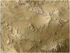
I'm trying to find the hexdraw templates for the new style maps. I may be mistaken but I think the templates listed in the sticky for hexdraw templates at the top of the mod section are for the old style maps. If anyone could direct me I'd appreciate it. Thanks!
- Attachments
-
- Flashpoint.jpg (635.4 KiB) Viewed 1235 times

RE: Hexdraw templates for the new style maps.
The new maps were not created with Hexdraw. Will1am created them using MMQGIS and IIRC, Photoshop.
RE: Hexdraw templates for the new style maps.
Wow, that's bizarre. I never tried posting a photo on this forum before and it didn't show up in the preview so I figured I did something wrong. Anyway, the pic depicts a map with the type of hexdraw graphic templates I'm looking for. Thanks!
-
CapnDarwin

- Posts: 9515
- Joined: Sat Feb 12, 2005 3:34 pm
- Location: Newark, OH
- Contact:
RE: Hexdraw templates for the new style maps.
Stimpak is correct. Once we went to Williams art and methods we ended up with better looking maps, but it also makes it impractical to mod. There are a number of ways to mimic the look if you have the right art programs and the map values editor still works with any scaled image you load up. So you can still do you own maps. Plus the old stuff still works. [8D]
OTS is looking forward to Southern Storm getting released!
Cap'n Darwin aka Jim Snyder
On Target Simulations LTD
Cap'n Darwin aka Jim Snyder
On Target Simulations LTD
RE: Hexdraw templates for the new style maps.
Oh bummer. I thought I'd downloaded a while back a template that was used for this style map. In any event, they seemed different from the templates used as the original graphics. I didn't try doing a map with them at the time but I did preview the files just to take a look at them. If anyone could let me know if they know what they might have been. Or you could let me know that I must be losing my marbles but I already know that 
RE: Hexdraw templates for the new style maps.
Also, do you know why William used MMQGIS? I'm a bit familiar with paint.net and have been weighing whether to use that rather than hexdraw since paint.net allows vector drawing as well. There's trade-offs for both imo. If MMQGIS has some feature that lends itself to creating FCRS maps I'll consider that as well.
RE: Hexdraw templates for the new style maps.
Xenomorph, I'm still using the colors from the HexDraw templates to feed the map into the Map Values editor. However, I'm rendering a prettier version of that info with additional labels for use during the game. The rendering is not template based.
I switched from HexDraw to QGis because QGis allows me to easily place satellite images, topo maps, Open street map data on the map, and draw on top of that (A). Furthermore, with QGis I can load up digital elevation data and render it according to the FCRS elevation palette, so I don't have to set elevation values for 1380 hexes per map. I've set-up styles so with QGis I can generate 'HexDraw' like input for the Map Values editor (B).
These then are rendered in one or more styles (C, D).
Once I'm a bit further ahead with Southern Storm maps, I should be able to find some time to write a brief manual on creating maps with QGis. QGis is definitely more complex than a paint program. It takes a while getting familiar with these GIS terms, and figuring out how to import DEM and (optionally) OpenStreetMap data.
William
- Attachments
-
- qgis_map_p..ion_1280.jpg (577.31 KiB) Viewed 1240 times
William
On Target Simulations LLC
On Target Simulations LLC
-
BeirutDude

- Posts: 2799
- Joined: Sat Apr 27, 2013 9:44 am
- Location: Jacksonville, FL, USA
RE: Hexdraw templates for the new style maps.
W1ll14m,
So I'm an ArcMap guy, but I can't figure out how to overlay aa hex Grid on an ESRI map/ArcMap. Can you overlay a hex grid in QGIS? Also how different is it from ArcMap? Would my learning curve be huge? I know the advantage is open source and free!
Al
So I'm an ArcMap guy, but I can't figure out how to overlay aa hex Grid on an ESRI map/ArcMap. Can you overlay a hex grid in QGIS? Also how different is it from ArcMap? Would my learning curve be huge? I know the advantage is open source and free!
Al
"Some people spend an entire lifetime wondering if they made a difference. The Marines don't have that problem."
PRESIDENT RONALD REAGAN, 1985
I was Navy, but Assigned TAD to the 24th MAU Hq in Beirut. By far the finest period of my service!
PRESIDENT RONALD REAGAN, 1985
I was Navy, but Assigned TAD to the 24th MAU Hq in Beirut. By far the finest period of my service!
RE: Hexdraw templates for the new style maps.
Beachinnole,
Cannot tell how different QGis is from Arcmap, since I'm not familiar with Arcmap. When starting with QGis, I had little GIS background (which bit me a lot later when I discovered most of my maps were using the wrong coordinate system and consequently had the wrong scale). In your case, with your GIS background, you should have fewer problems.
For QGis, there's the MMQGIS plug-in which can generate a hex grid overlay layer (.shp file) for a specific area. And, from QGis 2.12 onwards, it has become very easy to snap towards arbitrary layers (such as the hex grid layer), speeding up the painting of field and forest polygons for me.
If you need help setting up the coordinate systems, MMQGIS inputs, and print composers for use with FCRS, just let me know.
William
William
On Target Simulations LLC
On Target Simulations LLC
-
BeirutDude
- Posts: 2799
- Joined: Sat Apr 27, 2013 9:44 am
- Location: Jacksonville, FL, USA
RE: Hexdraw templates for the new style maps.
Not sure I'm going down this route but just out of interest (and my work wants to convert to QGIS due to costs) Which coordinate system are FP:RS maps in? Also what scale are you using for the maps?
"Some people spend an entire lifetime wondering if they made a difference. The Marines don't have that problem."
PRESIDENT RONALD REAGAN, 1985
I was Navy, but Assigned TAD to the 24th MAU Hq in Beirut. By far the finest period of my service!
PRESIDENT RONALD REAGAN, 1985
I was Navy, but Assigned TAD to the 24th MAU Hq in Beirut. By far the finest period of my service!
RE: Hexdraw templates for the new style maps.
Map scale is 500 meters from center of hex to center of hex. Standard map size is 20km east-west and 15km north-south, or 46 hexes by 30 hexes.
-
BeirutDude
- Posts: 2799
- Joined: Sat Apr 27, 2013 9:44 am
- Location: Jacksonville, FL, USA
RE: Hexdraw templates for the new style maps.
OK so bit the bullet and loaded QGIS, so going to start playing with it.
"Some people spend an entire lifetime wondering if they made a difference. The Marines don't have that problem."
PRESIDENT RONALD REAGAN, 1985
I was Navy, but Assigned TAD to the 24th MAU Hq in Beirut. By far the finest period of my service!
PRESIDENT RONALD REAGAN, 1985
I was Navy, but Assigned TAD to the 24th MAU Hq in Beirut. By far the finest period of my service!
-
BeirutDude
- Posts: 2799
- Joined: Sat Apr 27, 2013 9:44 am
- Location: Jacksonville, FL, USA
RE: Hexdraw templates for the new style maps.
Definitely different than ArcMap! But I've never figured out how to create a hex grid in ArcMap. Crazy as MGRS and USNG are a snap as long as you're in the right projection!!!!
So In QGIS what projection and map scale are you working with. Also the MMQGIS what setting are you using?
So In QGIS what projection and map scale are you working with. Also the MMQGIS what setting are you using?
"Some people spend an entire lifetime wondering if they made a difference. The Marines don't have that problem."
PRESIDENT RONALD REAGAN, 1985
I was Navy, but Assigned TAD to the 24th MAU Hq in Beirut. By far the finest period of my service!
PRESIDENT RONALD REAGAN, 1985
I was Navy, but Assigned TAD to the 24th MAU Hq in Beirut. By far the finest period of my service!
RE: Hexdraw templates for the new style maps.
Beachinnole,
great to see you biting the bullet. Here are the most important settings I use:
Projection system and hex grid
- use one of the WGS / UTM zones for your region to have a correct scale. For Germany, that's UTM zone 32N
- allow On-the-fly transformation, so QGIS can map 'bitmap tiles' from Web services (Google, Bing, OSM) correctly (otherwise, they won't line up in the right spot)
- just for orientation, I prefer to have a 5km visual grid to plan my 20x15km map box; View, Decorations, 5000, 5000, Line. I create a map box rectangle in a separate layer in order to plan the map area.
- make sure the UTM 32N is the active CRS when you create the hex grid layer using MMQGIS
- to cover the 20x15km, I create a slightly larger hex grid layer (23x17.5km) in MMQGIS using the following MMQGIS, Create, Create Grid Layer, Width 23000, Height 17500, Hexagon (polygon) and V Spacing of 500. The H Spacing of 433 follows automatically. After creation, explicitly set the UTM zone 32N as the newly created layer's CRS.
Print Composer (the thing that generates your map as a bitmap)
- To export a 'standard size' (20x15km 46x30 hex) FCRS map at the right scale (2 hex = 2x 500m = 1km = 128 pixels), create a New Print Composer. In Composition, Page Size, Preset = Custom, switch to Units = inches, then set Width to 20.10", Height to 15.25". Change Export Setting, Export Resolution to 128dpi. Switch to the Item tab. Use Layout, Add Map to draw a Map item from the page's top left corner to top right corner. In the Item Properties, set scale to 39370 (this is the magic number corresponding to a 1" = 1km = 2 x 500 hex = 128 dpi; 1km : 1" = 2.54cm corresponds to 39370:1).
Making the Print Composer focus on the map area is a bit cumbersome. I select my map box rectangle in QGis, use Ctrl+J to View, Zoom to Selection. Next switch to Print Composer, in Item Properties, press 'Set to Map Canvas Extent', and repair the Scale again to 39370. The next thing is to export the bitmap, using Print Composer, Composer, Export as Image, save a .png file, and confirm the Export Options (128dpi, 2572px x 1952px).
Load it into FCRS, and check whether the grid lines line up with FCRS grid (select Elevation in FCRS map editor). If they don't you can either shift the hex grid layer in QGis, or change the extents in the Print Composer, Item properties, Extents. The Extents are given in meters, so you can shift the map horizontally by half a hex by adding 250 to the X min and X max extents. Be sure to preserve the 39370 scale.
Once you've done this, making a QGis change, updating the Print Composer (preview) to generate a new bitmap is a straightforward process.
Note: everytime you load in a Web service map, QGis will switch to an OTF CRS (typically "Generated CRS (+proj=longlat +ellps=IGNF:ELG053 +no_defs)"). The Print Composer cannot handle this and won't show good output until you switch the project back to UTM zone 32N. You might have to switch back to Generated CRS to continue working with a Web service map.
William
William
On Target Simulations LLC
On Target Simulations LLC
-
BeirutDude
- Posts: 2799
- Joined: Sat Apr 27, 2013 9:44 am
- Location: Jacksonville, FL, USA
RE: Hexdraw templates for the new style maps.
William,
Thanks for taking the time. I bought HexDraw and played with it today (before work) and just did the first QGIS Tutorial (At work, they're paying me to do it as well as they want to move over to QGIS for some applications and field work). I like the on the fly transformations! MUCH EASIER THAN ArcMap!!!!! Actually, a lot of what I have seen so far is more intuitive than ArcMAp just have to get used to the knobology. Thanks for all of the time. I'll go over your points, and I'm sure I'll have a lot of questions. I calculated at a map scale of 1:12500 should be 20 mm to 250 meters and 1:25000 should be 20 mm to 500 meters for HexDraw. Does that sound right to you?
Al
"Some people spend an entire lifetime wondering if they made a difference. The Marines don't have that problem."
PRESIDENT RONALD REAGAN, 1985
I was Navy, but Assigned TAD to the 24th MAU Hq in Beirut. By far the finest period of my service!
PRESIDENT RONALD REAGAN, 1985
I was Navy, but Assigned TAD to the 24th MAU Hq in Beirut. By far the finest period of my service!
-
BeirutDude
- Posts: 2799
- Joined: Sat Apr 27, 2013 9:44 am
- Location: Jacksonville, FL, USA
RE: Hexdraw templates for the new style maps.
Oh BTW what are the base rasters/shapefiles you are using? I've only ever done U.S. and Caribbean applications. So I'm not familiar with European databases.
"Some people spend an entire lifetime wondering if they made a difference. The Marines don't have that problem."
PRESIDENT RONALD REAGAN, 1985
I was Navy, but Assigned TAD to the 24th MAU Hq in Beirut. By far the finest period of my service!
PRESIDENT RONALD REAGAN, 1985
I was Navy, but Assigned TAD to the 24th MAU Hq in Beirut. By far the finest period of my service!
-
BeirutDude
- Posts: 2799
- Joined: Sat Apr 27, 2013 9:44 am
- Location: Jacksonville, FL, USA
RE: Hexdraw templates for the new style maps.
William,
Thank you soooooooo much for the help. I've been trying to get a hex grid into ArcMap for about a year. With your help first day on QGIS and I have one at 250 meters over my house and neighborhood! QGIS is pretty intuitive!
Al

Thank you soooooooo much for the help. I've been trying to get a hex grid into ArcMap for about a year. With your help first day on QGIS and I have one at 250 meters over my house and neighborhood! QGIS is pretty intuitive!
Al
- Attachments
-
- Marsh_Hammock_QGIS2.jpg (138.78 KiB) Viewed 1237 times
"Some people spend an entire lifetime wondering if they made a difference. The Marines don't have that problem."
PRESIDENT RONALD REAGAN, 1985
I was Navy, but Assigned TAD to the 24th MAU Hq in Beirut. By far the finest period of my service!
PRESIDENT RONALD REAGAN, 1985
I was Navy, but Assigned TAD to the 24th MAU Hq in Beirut. By far the finest period of my service!
RE: Hexdraw templates for the new style maps.
Looks great.
Wrt base rasters and shape files:
For Germany elevation data, you'd need SRTM_38_02 and SRTM_39_02 (northen part) and SRTM_38_03 and SRTM_39_03. These are free downloads from, for example, http://srtm.csi.cgiar.org.
I have a bunch of layer styles to map a 500m elevation range in steps of 50m to FCRS elevation colors, from base height 0 to base height 400 in steps of 25m. Using those, there's no need to spend much time on setting elevation values in the Map Values Editor.
Wrt shape files. I don't recommend you importing OSM data, as in general it's close but not good enough; fields and forests often are missing (or misclassified), and none of it aligns well with hexes. Doing the occasional map, you're better off drawing on top of a Google / Bing / map / satellite photo.
That being said, I did invest in importing OSM data for Germany, filtering out the key elements, so I can quickly see and show (in FCRS colors) what a given area would do in the game. This involves a good amount of patience, a computer with a good amount of memory and some puzzling with OSM annotations.
I do draw all my map elements manually on top of satellite views.
Wrt scales in HexDraw: I don't have a clue. I started with QGis because I didn't like the lengthy edit-cycle of seeing a problem in the map, making the HexDraw change, exporting a HexDraw bitmap, cropping the bitmap, then loading it into FCRS. With QGis, it's a single step once set-up, and in QGis, I can change a road from a highway to a secondary just by selecting it in the 'Highway' layer, deleting it there and pasting it into the 'Secondary Road' layer. Try that in HexDraw.
For 250m maps, create the grid with 250m vertical height (as you've done), and use scale 39370/2 = 19865 in the Print composer.
William
William
On Target Simulations LLC
On Target Simulations LLC
-
BeirutDude
- Posts: 2799
- Joined: Sat Apr 27, 2013 9:44 am
- Location: Jacksonville, FL, USA
RE: Hexdraw templates for the new style maps.
William,
Thanks. Your way ahead of me in GIS skills. I mainly work with shape files and storm surge analysis. I understood a good bit of your posts above but not al. I have been playing with the MMQGIS hex grid over the southeastern CONUS where I have good data but it is a bit squirrelly. Lot of trial and error to get a proper grids paving in the projection. It seems to be working in degree coordinates. In any case thanks for your help.
Al
"Some people spend an entire lifetime wondering if they made a difference. The Marines don't have that problem."
PRESIDENT RONALD REAGAN, 1985
I was Navy, but Assigned TAD to the 24th MAU Hq in Beirut. By far the finest period of my service!
PRESIDENT RONALD REAGAN, 1985
I was Navy, but Assigned TAD to the 24th MAU Hq in Beirut. By far the finest period of my service!
RE: Hexdraw templates for the new style maps.
YES, eindelijk, something useful.

- Attachments
-
- Zeven.jpg (298.85 KiB) Viewed 1238 times