Maps

Post new mods and scenarios here.

Moderator: MOD_Flashpoint

Post Reply
User avatar
22sec
Posts: 1230
Joined: Sat Dec 11, 2004 4:09 pm
Location: Jackson, MS
Contact:

Maps

Post by 22sec »

I thought I would wet everyone's appetites that had any interest in map editing, while waiting for the upcoming mod guides.
The maps that ship with the game are wonderful, but a lot of people like to put their own spin on things :mrgreen:

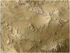
The JPG - this is what you see when playing. So you could do something like:
OSMtest.jpg
OSMtest.jpg (3.68 MiB) Viewed 4191 times
Flashpoint Campaigns Contributor
https://twitter.com/22sec2
User avatar
22sec
Posts: 1230
Joined: Sat Dec 11, 2004 4:09 pm
Location: Jackson, MS
Contact:

Re: Maps

Post by 22sec »

I added hill shade to an OSM map. It's my experience that the challenge with real maps is elevation, the hill shading helps me some.
Flashpoint Campaigns Contributor
https://twitter.com/22sec2
User avatar
22sec
Posts: 1230
Joined: Sat Dec 11, 2004 4:09 pm
Location: Jackson, MS
Contact:

Re: Maps

Post by 22sec »

One more:
Test_topo.jpg
Test_topo.jpg (3.9 MiB) Viewed 4189 times
Flashpoint Campaigns Contributor
https://twitter.com/22sec2
User avatar
22sec
Posts: 1230
Joined: Sat Dec 11, 2004 4:09 pm
Location: Jackson, MS
Contact:

Re: Maps

Post by 22sec »

The FP10 file and Map Values Editor is where all the underlying data is generated and processed. The Map Values Editor is a fun tool for those willing to try.
MVE.jpg
MVE.jpg (640.08 KiB) Viewed 4185 times
Flashpoint Campaigns Contributor
https://twitter.com/22sec2
User avatar
22sec
Posts: 1230
Joined: Sat Dec 11, 2004 4:09 pm
Location: Jackson, MS
Contact:

Re: Maps

Post by 22sec »

The PNG File - The map value editor will scan the png and ultimately produce your fp10 file. The png contains all the data based off the RGB values defined in the map data type file.

Here is a closer look from in-game:
MVE2.jpg
MVE2.jpg (266.3 KiB) Viewed 4162 times
Flashpoint Campaigns Contributor
https://twitter.com/22sec2
User avatar
22sec
Posts: 1230
Joined: Sat Dec 11, 2004 4:09 pm
Location: Jackson, MS
Contact:

Re: Maps

Post by 22sec »

The png file is it must contain elevation data, and may also contain terrain data. The trick is making sure if you have terrain data in a hex that that the elevation data can be scanned in that hex as well. You can see that in the above pic.
Flashpoint Campaigns Contributor
https://twitter.com/22sec2
User avatar
DCETRADER
Posts: 28
Joined: Tue Jul 09, 2013 10:25 am

Re: Maps

Post by DCETRADER »

I hope there will be more alternative maps can be published offical FTP.
Thanks team!
Last edited by DCETRADER on Sat May 06, 2023 11:26 am, edited 2 times in total.
Raptor Tactics Labs
User avatar
22sec
Posts: 1230
Joined: Sat Dec 11, 2004 4:09 pm
Location: Jackson, MS
Contact:

Re: Maps

Post by 22sec »

The Map Data Type File:
The Map Value Editor reads the RGB colors of the PNG file, and compares those colors to the data in the Map Data Type spreadsheet, and then generates the FP10 file the game uses. Because it's a spreadsheet it is easily moddable. Below is a screenshot from my map data type file I tinker with from time to time on my own.
MVE3.jpg
MVE3.jpg (205.58 KiB) Viewed 3879 times
Flashpoint Campaigns Contributor
https://twitter.com/22sec2
User avatar
22sec
Posts: 1230
Joined: Sat Dec 11, 2004 4:09 pm
Location: Jackson, MS
Contact:

Re: Maps

Post by 22sec »

This is just a glimpse of what's possible. You can lots of different things, this particular spreadsheet also does elevation in 16m intervals, so if it's in the Map Data Type file it can be modded...
Flashpoint Campaigns Contributor
https://twitter.com/22sec2
User avatar
22sec
Posts: 1230
Joined: Sat Dec 11, 2004 4:09 pm
Location: Jackson, MS
Contact:

Re: Maps

Post by 22sec »

MapMod.jpg
MapMod.jpg (1.33 MiB) Viewed 3756 times
Flashpoint Campaigns Contributor
https://twitter.com/22sec2
User avatar
22sec
Posts: 1230
Joined: Sat Dec 11, 2004 4:09 pm
Location: Jackson, MS
Contact:

Re: Maps

Post by 22sec »

MapMod2.jpg
MapMod2.jpg (996.67 KiB) Viewed 3755 times
Flashpoint Campaigns Contributor
https://twitter.com/22sec2
ctcharger
Posts: 102
Joined: Sun Mar 12, 2017 11:35 am
Location: Akron, OH

Re: Maps

Post by ctcharger »

That looks pretty cool! I have Steel Beast which has some maps. I just look at them however so I am not sure what data they have or how it could work here. They are detailed though and I can adjust the contour lines height if that helps.
User avatar
22sec
Posts: 1230
Joined: Sat Dec 11, 2004 4:09 pm
Location: Jackson, MS
Contact:

Re: Maps

Post by 22sec »

For anyone that has been paying attention to my modified concept map thread here is a more detail look at what is going on under the hood.
I've tweaked my Map Data Type file for the upcoming fourth version.
MVE4.jpg
MVE4.jpg (486.45 KiB) Viewed 3417 times
Here is the center of Bayreuth from my png file, and then a photo from Google Earth of the same location. The resulting cover, concelment, mobility ratings and object height feel right.
Hood.jpg
Hood.jpg (228.32 KiB) Viewed 3417 times
BayreuthActual.jpg
BayreuthActual.jpg (447.14 KiB) Viewed 3416 times
Flashpoint Campaigns Contributor
https://twitter.com/22sec2
User avatar
22sec
Posts: 1230
Joined: Sat Dec 11, 2004 4:09 pm
Location: Jackson, MS
Contact:

Re: Maps

Post by 22sec »

Using a satellite based image for the jpg is a challenge for many reasons. The one I realized that needed to be addressed after playtesting is making sure the data under the hood, matches what the player expects. The below area in version three only used Corrine Land Data from 1990, and more often then not the resolution for that data isn't as detailed as current data. In version 4 I've added key wooded areas, and in this case it basically tripled the cover and concealment at this location. In some instances though, the land has changed so we need reference material, I prefer Landsat satellite image from the late 80's to produce historically accurate maps. It becomes a matter of personal preference, and the engine let's you do that if you want.
MVE6.jpg
MVE6.jpg (33.53 KiB) Viewed 3409 times
The other addition coming in version four is the addition of smaller, tertiary (or county) type roads.
Attachments
Hood2.jpg
Hood2.jpg (2.17 MiB) Viewed 3409 times
Flashpoint Campaigns Contributor
https://twitter.com/22sec2
blond_knight_new
Posts: 76
Joined: Sun Jun 08, 2014 9:01 pm

Re: Maps

Post by blond_knight_new »

OK so I understand that everything regarding map making is now controlled by colors.
I wanted to see that in action so I converted Aichelberg.jpg into test.png and imported it into the map editor.
When I clicked the "scan for map values" button it found a bunch of unknown hexes, and mis-identified most of the wooded hexes for major roads.
Were these map jpg files altered after the editor created the fp10 files?
And can you give us a generic map template to tinker with?
User avatar
WildCatNL
Posts: 816
Joined: Fri Mar 27, 2009 5:21 pm
Location: Eindhoven, the Netherlands

Re: Maps

Post by WildCatNL »

blond_knight_new wrote: Mon May 15, 2023 11:51 pm OK so I understand that everything regarding map making is now controlled by colors.
I wanted to see that in action so I converted Aichelberg.jpg into test.png and imported it into the map editor.
When I clicked the "scan for map values" button it found a bunch of unknown hexes, and mis-identified most of the wooded hexes for major roads.
Were these map jpg files altered after the editor created the fp10 files?
And can you give us a generic map template to tinker with?
Hi, good questions. The upcoming map creation manual (+ example QGis project) should go a long way answering these questions. Since it is still upcoming:
three_step_map_creation_process.png
three_step_map_creation_process.png (1.63 MiB) Viewed 3084 times
We use a three step map creation process, where we first generate a bitmap (.png) file that suited for scanning, not for "human consumption". The second step is to scan that .png and convert it to a .fp10 file, which tells the game what the terrain and obstacles are. And, optionally, a third step to create a more artistic map graphics (.jpg) from the terrain, to be "consumed" by the player. For each map, you'll find four different .jpg file: the main game map, a briefing variant, and two thumbnail maps, one for use in the minimap, and another for map selection in the scenario editor.

We'll be publishing a modding guide that will take you from scratch through creation of the scannable .png and .fp10 creation, along with an example project for QGis. Creation of a pretty .jpg to match that terrain is left to you.
William
On Target Simulations LLC
Nelsonxu3320
Posts: 7
Joined: Mon Jun 06, 2022 9:44 pm

Re: Maps

Post by Nelsonxu3320 »

Hi! Is the guide for map making with QGIS available now?
User avatar
dpabrams
Posts: 184
Joined: Tue Mar 29, 2005 3:45 pm
Location: Casper, Wyoming

Re: Maps

Post by dpabrams »

What do you use to open and edit the fp10 file?
Vote for Pedro
User avatar
CapnDarwin
Posts: 9510
Joined: Sat Feb 12, 2005 3:34 pm
Location: Newark, OH
Contact:

Re: Maps

Post by CapnDarwin »

Guides for Modding, including map making basics, will be out in April (assuming all goes well). Content Creation docs will be in the next 2.1.4 update soon. I'm reviewing them now.
OTS is looking forward to Southern Storm getting released!

Cap'n Darwin aka Jim Snyder
On Target Simulations LTD
Post Reply

Return to “Mods and Scenarios”