Page 1 of 1
Maps
Posted: Tue Nov 22, 2022 7:34 pm
by 22sec
I thought I would wet everyone's appetites that had any interest in map editing, while waiting for the upcoming mod guides.
The maps that ship with the game are wonderful, but a lot of people like to put their own spin on things

The JPG - this is what you see when playing. So you could do something like:
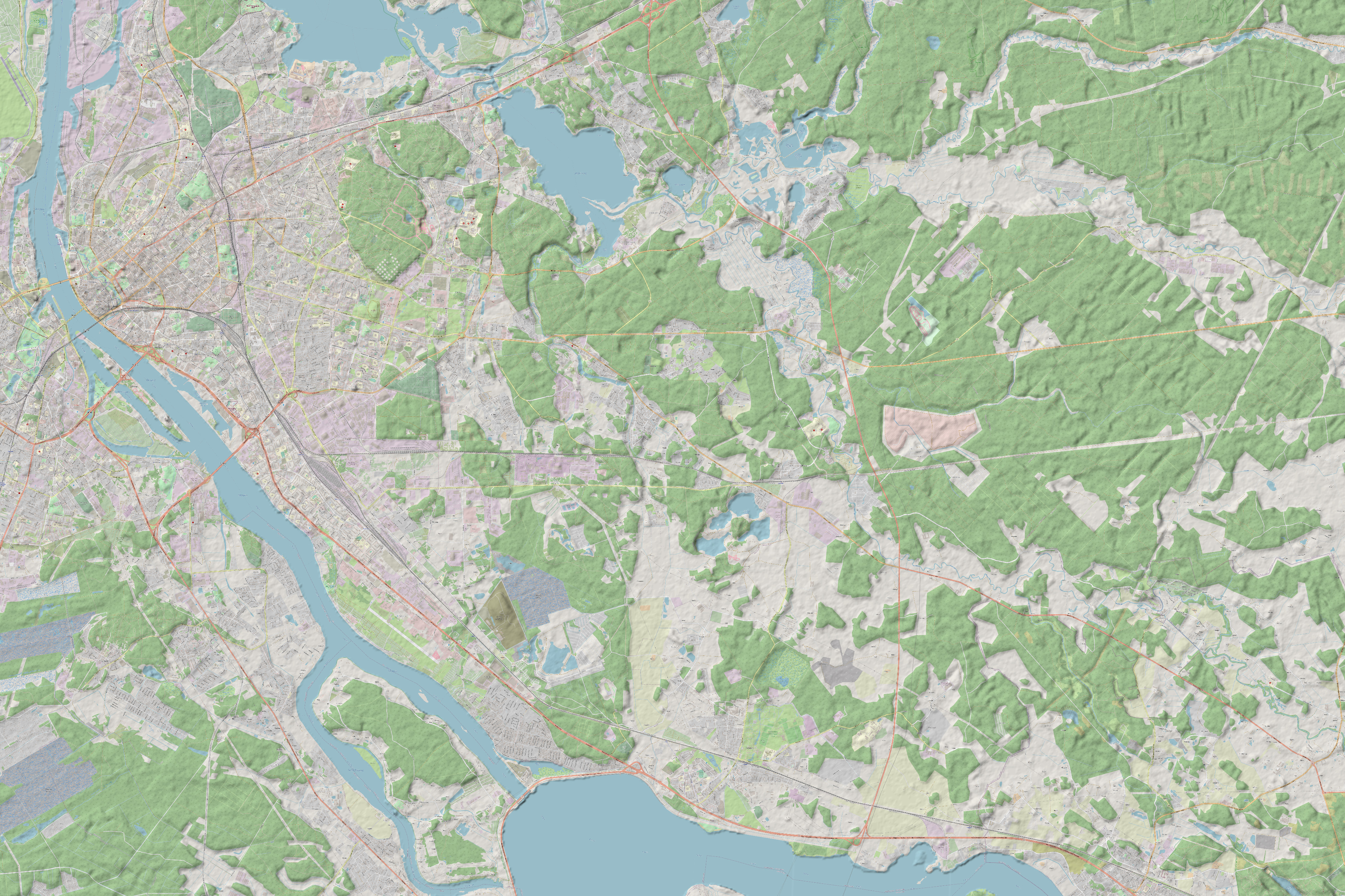
- OSMtest.jpg (3.68 MiB) Viewed 5931 times
Re: Maps
Posted: Tue Nov 22, 2022 7:36 pm
by 22sec
I added hill shade to an OSM map. It's my experience that the challenge with real maps is elevation, the hill shading helps me some.
Re: Maps
Posted: Tue Nov 22, 2022 7:36 pm
by 22sec
One more:
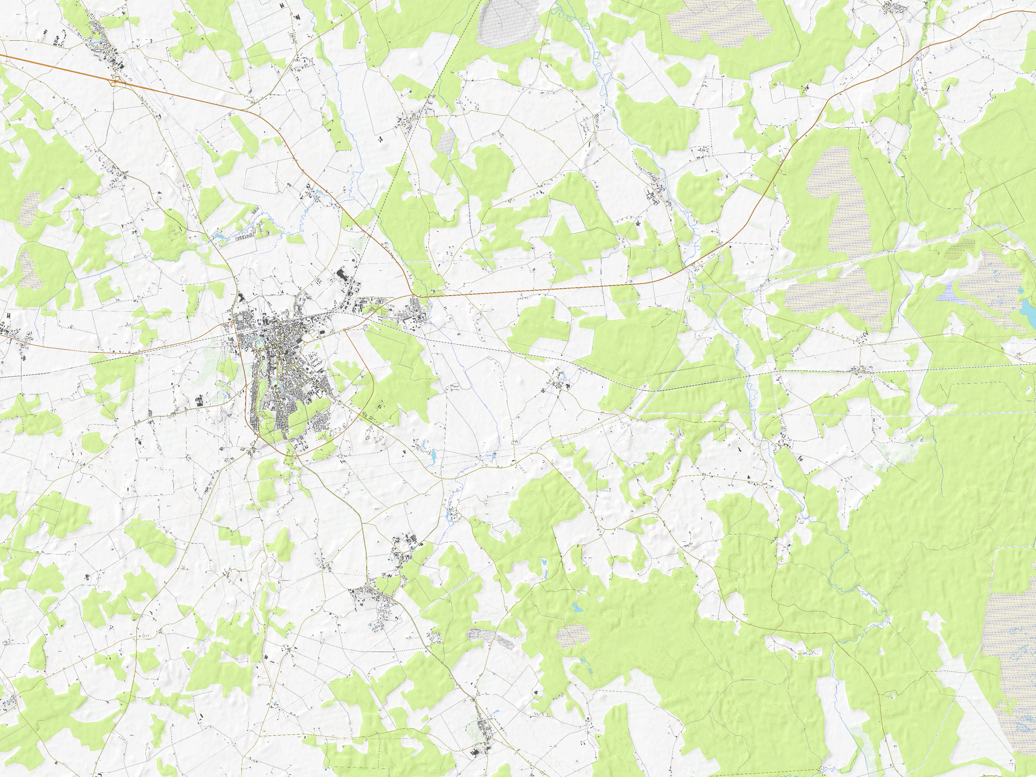
- Test_topo.jpg (3.9 MiB) Viewed 5929 times
Re: Maps
Posted: Tue Nov 22, 2022 7:48 pm
by 22sec
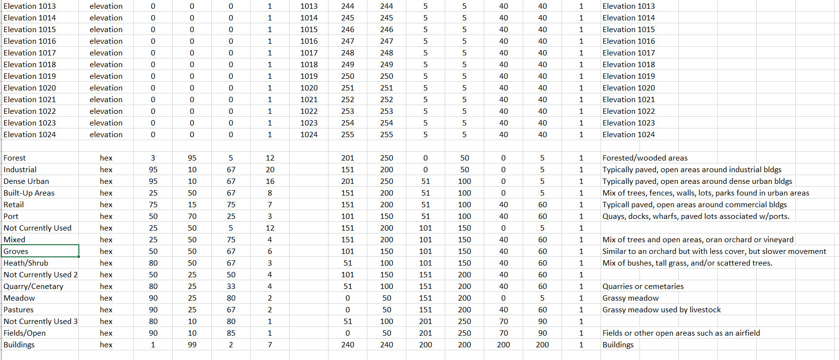
The FP10 file and Map Values Editor is where all the underlying data is generated and processed. The Map Values Editor is a fun tool for those willing to try.
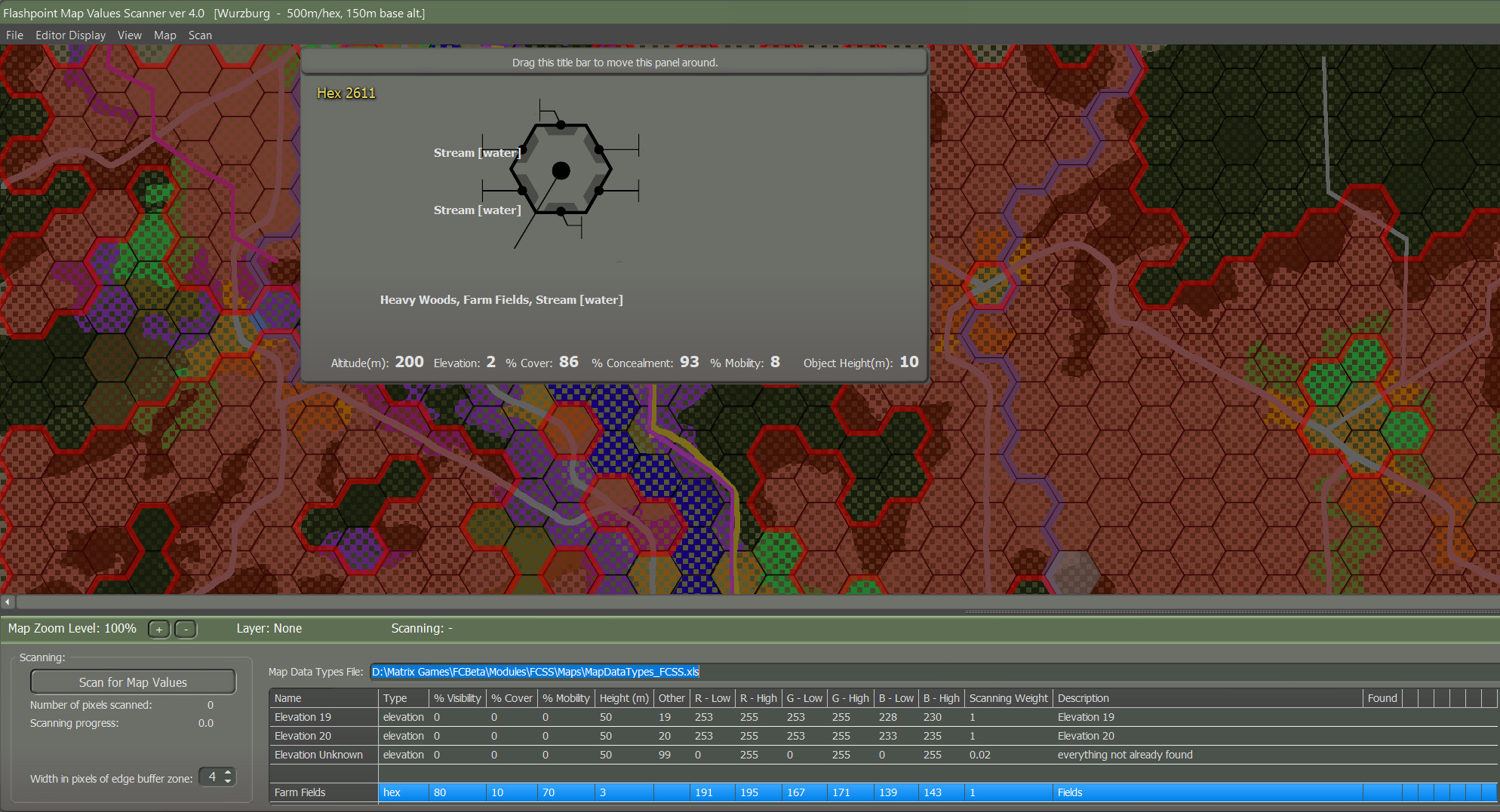
- MVE.jpg (640.08 KiB) Viewed 5925 times
Re: Maps
Posted: Tue Nov 22, 2022 9:01 pm
by 22sec
The PNG File - The map value editor will scan the png and ultimately produce your fp10 file. The png contains all the data based off the RGB values defined in the map data type file.
Here is a closer look from in-game:
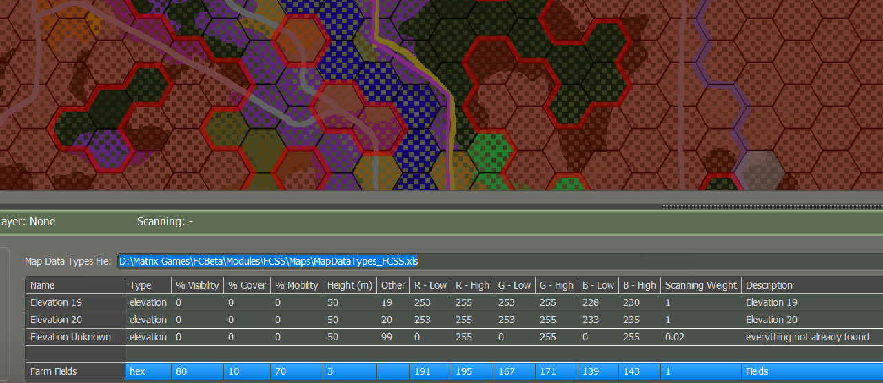
- MVE2.jpg (266.3 KiB) Viewed 5902 times
Re: Maps
Posted: Tue Nov 22, 2022 9:11 pm
by 22sec
The png file is it must contain elevation data, and may also contain terrain data. The trick is making sure if you have terrain data in a hex that that the elevation data can be scanned in that hex as well. You can see that in the above pic.
Re: Maps
Posted: Wed Nov 23, 2022 10:26 am
by DCETRADER
I hope there will be more alternative maps can be published offical FTP.
Thanks team!
Re: Maps
Posted: Sun Dec 04, 2022 11:26 pm
by 22sec
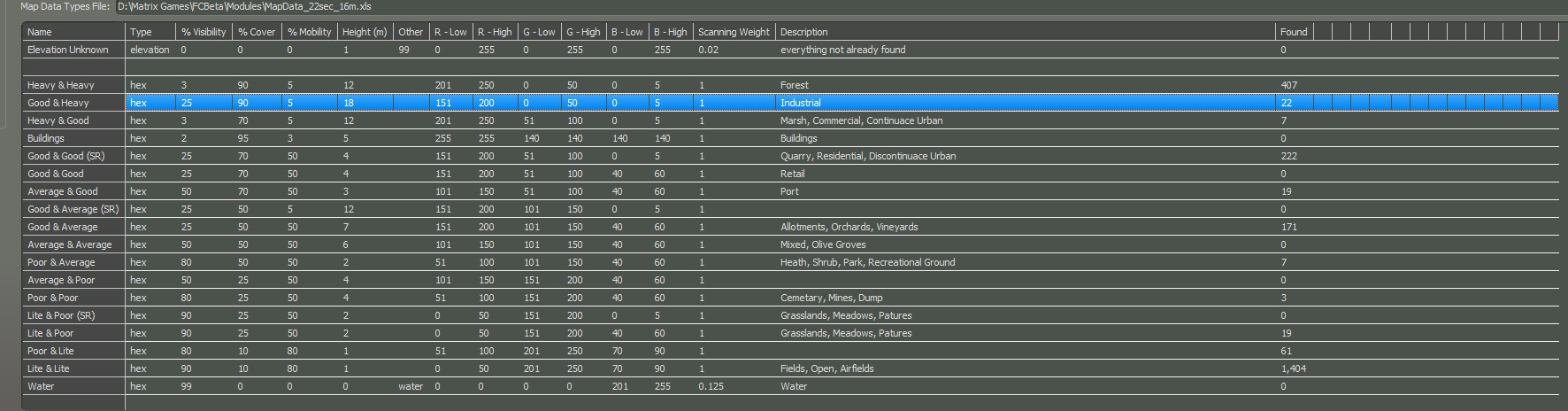
The Map Data Type File:
The Map Value Editor reads the RGB colors of the PNG file, and compares those colors to the data in the Map Data Type spreadsheet, and then generates the FP10 file the game uses. Because it's a spreadsheet it is easily moddable. Below is a screenshot from my map data type file I tinker with from time to time on my own.
- MVE3.jpg (205.58 KiB) Viewed 5619 times
Re: Maps
Posted: Sun Dec 04, 2022 11:29 pm
by 22sec
This is just a glimpse of what's possible. You can lots of different things, this particular spreadsheet also does elevation in 16m intervals, so if it's in the Map Data Type file it can be modded...
Re: Maps
Posted: Wed Dec 07, 2022 4:37 pm
by 22sec
- MapMod.jpg (1.33 MiB) Viewed 5496 times
Re: Maps
Posted: Wed Dec 07, 2022 4:38 pm
by 22sec

- MapMod2.jpg (996.67 KiB) Viewed 5495 times
Re: Maps
Posted: Sun Dec 25, 2022 3:18 pm
by ctcharger
That looks pretty cool! I have Steel Beast which has some maps. I just look at them however so I am not sure what data they have or how it could work here. They are detailed though and I can adjust the contour lines height if that helps.
Re: Maps
Posted: Wed Feb 01, 2023 5:44 pm
by 22sec
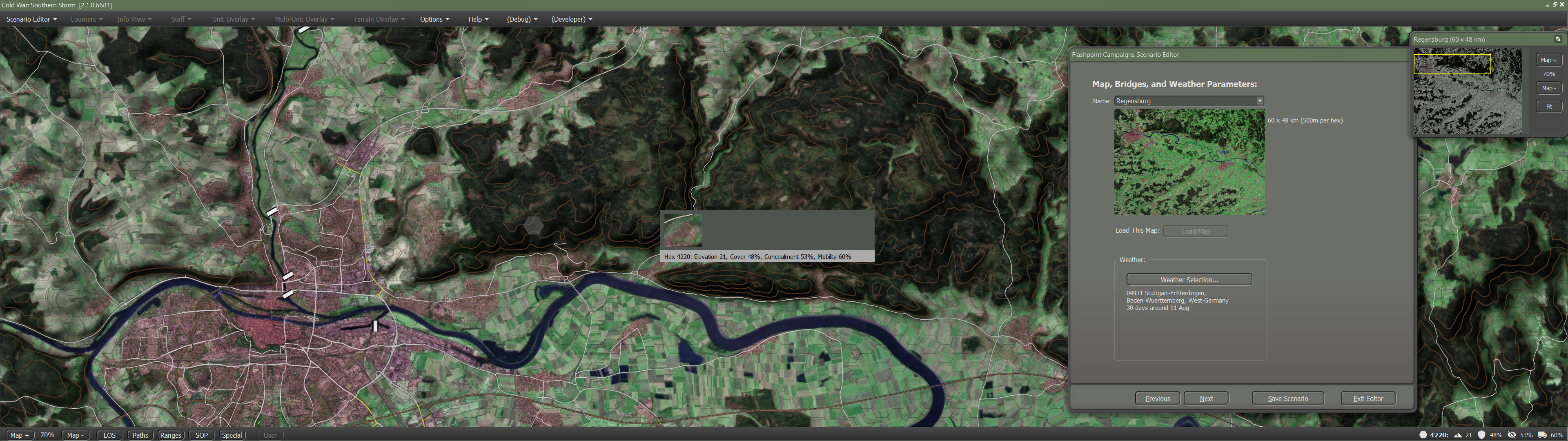
For anyone that has been paying attention to my modified concept map thread here is a more detail look at what is going on under the hood.
I've tweaked my Map Data Type file for the upcoming fourth version.
- MVE4.jpg (486.45 KiB) Viewed 5157 times
Here is the center of Bayreuth from my png file, and then a photo from Google Earth of the same location. The resulting cover, concelment, mobility ratings and object height feel right.

- Hood.jpg (228.32 KiB) Viewed 5157 times

- BayreuthActual.jpg (447.14 KiB) Viewed 5156 times
Re: Maps
Posted: Wed Feb 01, 2023 7:26 pm
by 22sec
Using a satellite based image for the jpg is a challenge for many reasons. The one I realized that needed to be addressed after playtesting is making sure the data under the hood, matches what the player expects. The below area in version three only used Corrine Land Data from 1990, and more often then not the resolution for that data isn't as detailed as current data. In version 4 I've added key wooded areas, and in this case it basically tripled the cover and concealment at this location. In some instances though, the land has changed so we need reference material, I prefer Landsat satellite image from the late 80's to produce historically accurate maps. It becomes a matter of personal preference, and the engine let's you do that if you want.

- MVE6.jpg (33.53 KiB) Viewed 5149 times
The other addition coming in version four is the addition of smaller, tertiary (or county) type roads.
Re: Maps
Posted: Mon May 15, 2023 11:51 pm
by blond_knight_new
OK so I understand that everything regarding map making is now controlled by colors.
I wanted to see that in action so I converted Aichelberg.jpg into test.png and imported it into the map editor.
When I clicked the "scan for map values" button it found a bunch of unknown hexes, and mis-identified most of the wooded hexes for major roads.
Were these map jpg files altered after the editor created the fp10 files?
And can you give us a generic map template to tinker with?
Re: Maps
Posted: Tue May 16, 2023 6:21 pm
by WildCatNL
blond_knight_new wrote: Mon May 15, 2023 11:51 pm
OK so I understand that everything regarding map making is now controlled by colors.
I wanted to see that in action so I converted Aichelberg.jpg into test.png and imported it into the map editor.
When I clicked the "scan for map values" button it found a bunch of unknown hexes, and mis-identified most of the wooded hexes for major roads.
Were these map jpg files altered after the editor created the fp10 files?
And can you give us a generic map template to tinker with?
Hi, good questions. The upcoming map creation manual (+ example QGis project) should go a long way answering these questions. Since it is still upcoming:
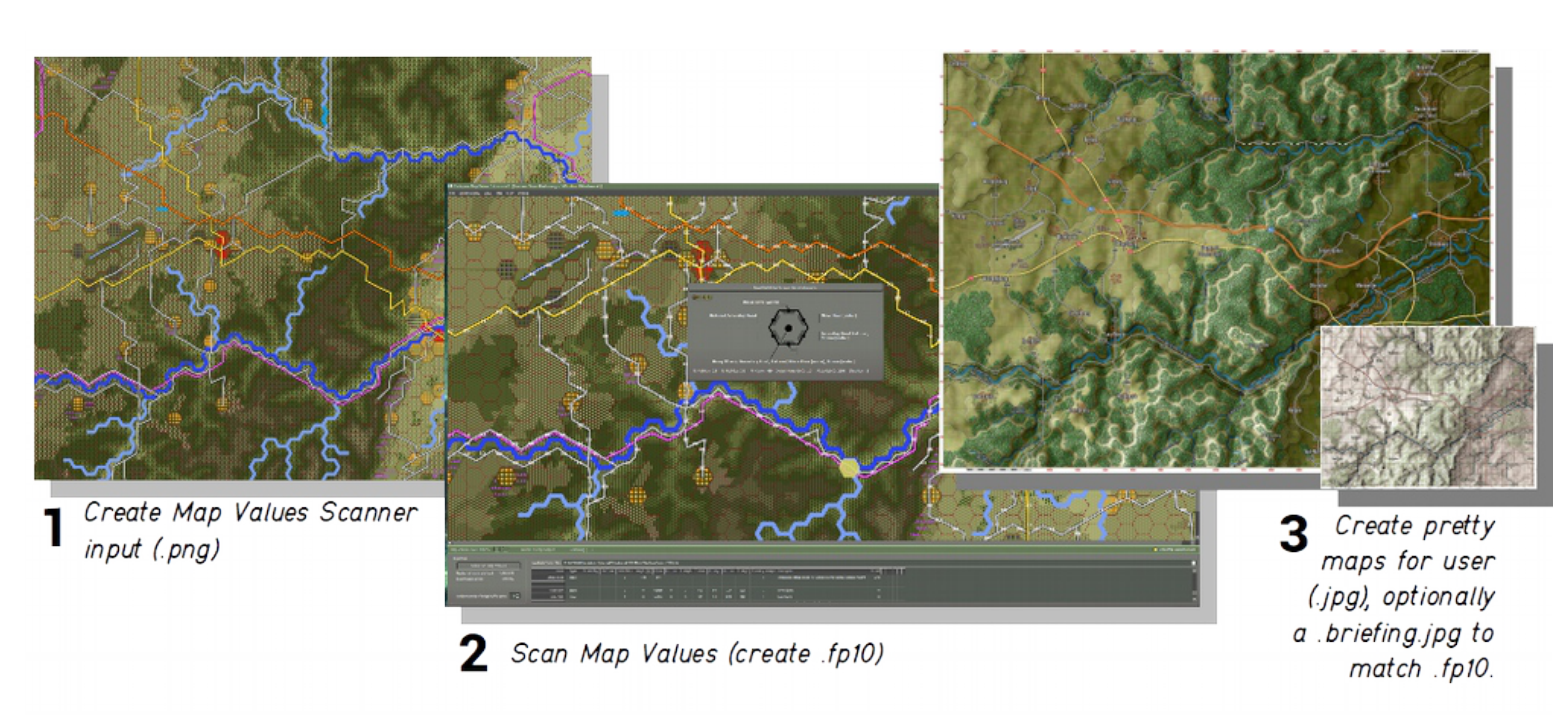
- three_step_map_creation_process.png (1.63 MiB) Viewed 4824 times
We use a three step map creation process, where we first generate a bitmap (.png) file that suited for scanning, not for "human consumption". The second step is to scan that .png and convert it to a .fp10 file, which tells the game what the terrain and obstacles are. And, optionally, a third step to create a more artistic map graphics (.jpg) from the terrain, to be "consumed" by the player. For each map, you'll find four different .jpg file: the main game map, a briefing variant, and two thumbnail maps, one for use in the minimap, and another for map selection in the scenario editor.
We'll be publishing a modding guide that will take you from scratch through creation of the scannable .png and .fp10 creation, along with an example project for QGis. Creation of a pretty .jpg to match that terrain is left to you.
Re: Maps
Posted: Sat Feb 03, 2024 12:09 am
by Nelsonxu3320
Hi! Is the guide for map making with QGIS available now?
Re: Maps
Posted: Wed Mar 13, 2024 11:42 am
by dpabrams
What do you use to open and edit the fp10 file?
Re: Maps
Posted: Wed Mar 13, 2024 3:48 pm
by CapnDarwin
Guides for Modding, including map making basics, will be out in April (assuming all goes well). Content Creation docs will be in the next 2.1.4 update soon. I'm reviewing them now.