


Hi, I found the shaded maps in the beta version on steam visually excellent. But in the last released open beta v1.05.1328.4 I noticed a loss of definition in wide shot, and some glitches with different textures in the same map. They were perfect before. I attach photos to explain better. i9-10900 CPU, 32 Gb Ram, SSD and Nvidia RTX 3080, Win 10.
Thank you.
[RESOLVED (REVERTED)] Texture definition?
Moderator: MOD_Command
[RESOLVED (REVERTED)] Texture definition?
- Attachments
-
- 22.7z
- (346.92 KiB) Downloaded 16 times
Re: Texture definition?
Hi
Confirm the issue.
Images 1 and 2 are from 1307.18 from steam with good quality and in the 1328.4 beta steam images 3 and 4 are very low quality.
Regards
Confirm the issue.
Images 1 and 2 are from 1307.18 from steam with good quality and in the 1328.4 beta steam images 3 and 4 are very low quality.
Regards
- Attachments
-
- cmano tiles.rar
- (6.69 MiB) Downloaded 23 times
Re: Texture definition?
Hello
This is still and issue in 1328.5 beta steam.
Regards
This is still and issue in 1328.5 beta steam.
Regards
Re: Texture definition?
As explained in the release notes of B1328.3: https://steamcommunity.com/app/1076160/ ... 447596618/
Dide < The layer misalignment at high camera altitude is a different issue and it has been fixed for the next update.
We are sorry it's not perfect everywhere, but by and large it's a better-looking and more functional tileset than before.* ADDED: The Sentinel-2 map layer now uses an improved custom-tuned tileset. This has several improvements:
- It is hill-shaded, and thus relief (terrain elevations) stand out much more prominently: https://imgur.com/a/urc9XXL
- Because of the shading, desert regions are less eyeball-melting: https://imgur.com/a/TTPUZOW
- It is water-masked, so coastal outlines are a lot crisper: https://imgur.com/a/RzDE4yZ
- Also because of the water-masking, water regions are transparent, so now you can combine it with bathymetry: https://imgur.com/a/PXOYLiY
- The tiles themselves are compressed to higher quality, so you should see less compression-artifacts on high zoom.
Dide < The layer misalignment at high camera altitude is a different issue and it has been fixed for the next update.

Re: [WAD + FIXED] Texture definition?
Hi
After a few hours of play i really dont see the improvements.
Going from this:

to this:
is not an improvement in my opinion, In some cases like this affects functionality when placing units in specific places.
More examples:
From this:
To this:

Regards
After a few hours of play i really dont see the improvements.
Going from this:
to this:
is not an improvement in my opinion, In some cases like this affects functionality when placing units in specific places.
More examples:
From this:
To this:
Regards
Re: [WAD + FIXED] Texture definition?
Here's a more favorable example: Attica peninsula (Greece) and surrounding Aegean islands:
Build 1307.19 (32 bit):

Build 1328.8 (64 bit):

In this example the revised S2 layer gives us several advantages:
* The S2 layer is now transparent at sea, so we can use a bathymetry layer together with it. In the old S2 layer this is not possible.
* The S2 layer now uses relief shading, which makes it MUCH easier to understand/visualize terrain elevation without needing to use the dedicated Relief+Bathymetry layer.
* Zooming-in even closer shows another benefit: Crisper coastlines:

* Another example:

^ Look at this area (Morocco, south of Gibraltar straits) in the 32-bit version and tell us how long before your eyeballs start melting from the too-bright, non-shaded tiles.
These are all real, tangible benefits for which a ton of work was dedicated. Are you sure you want to throw all of this out the window just because there are some issues here and there ?
Build 1307.19 (32 bit):
Build 1328.8 (64 bit):
In this example the revised S2 layer gives us several advantages:
* The S2 layer is now transparent at sea, so we can use a bathymetry layer together with it. In the old S2 layer this is not possible.
* The S2 layer now uses relief shading, which makes it MUCH easier to understand/visualize terrain elevation without needing to use the dedicated Relief+Bathymetry layer.
* Zooming-in even closer shows another benefit: Crisper coastlines:
* Another example:
^ Look at this area (Morocco, south of Gibraltar straits) in the 32-bit version and tell us how long before your eyeballs start melting from the too-bright, non-shaded tiles.
These are all real, tangible benefits for which a ton of work was dedicated. Are you sure you want to throw all of this out the window just because there are some issues here and there ?
-
boogabooga
- Posts: 980
- Joined: Wed Jul 18, 2018 12:05 am
Re: [WAD + FIXED] Texture definition?
Please don't take this personally Dimitris, but yes. There are more complaint threads here:Dimitris wrote: Wed Aug 23, 2023 7:43 pm These are all real, tangible benefits for which a ton of work was dedicated. Are you sure you want to throw all of this out the window just because there are some issues here and there ?
https://www.matrixgames.com/forums/view ... 0&t=397292
and here:
https://www.matrixgames.com/forums/view ... 0&t=397244
The shading is nice, but where the 'here and there' water mask issues are a complete butchering of certain coastlines and islands. Also, there are a lot of plains that are heavily pocked with false water mask. See North America.
That's clever, but unnecessary in my opinion. They don't need to be on at the same time- the player uses them at different times for different reasons. Bathymetry layer great for submarining (or anti-submarining) or mines. Sentinal-2 is great for placing facilities during scenario building, air ops, ground ops, etc. But mostly just to be beautiful.Dimitris wrote: Wed Aug 23, 2023 7:43 pm * The S2 layer is now transparent at sea, so we can use a bathymetry layer together with it. In the old S2 layer this is not possible.
Please examine your argument. First you say the purpose of the change is so the player can use the Bathymetry layer at the same time. Then you turn around and say the purpose of the change is so you don't need that same layer. That does not make sense, in my opinion.Dimitris wrote: Wed Aug 23, 2023 7:43 pm * The S2 layer now uses relief shading, which makes it MUCH easier to understand/visualize terrain elevation without needing to use the dedicated Relief+Bathymetry layer.
Can we at least choose which layer we want?
Please don't hate me.
The boogabooga doctrine for CMO: Any intentional human intervention needs to be able to completely and reliably over-ride anything that the AI is doing at any time.
Re: [WAD + FIXED] Texture definition?
No hate, and your arguments are fair and under consideration.
We are trying to navigate through various options and do what's best for most (ideally everyone).
We are trying to navigate through various options and do what's best for most (ideally everyone).
Re: Texture definition?
The relief shading to better view terrain elevation and the low bright in some zones (specially desert zones) is really helpful and improve the tiles.
However the amazing detail that we had in sentinel 2 is almost gone in most areas and for me is not worth it.
The first two images show very well what i mean i think it may have to do with the crisper coastlines and relief shading, the problem is that in sentinel 2 tiles you expect to see high res tiles despite loosing perspective of relief.
Right now BMNG layer is almost the same as sentinel 2 in most areas showing the terrain relief but if you want high resolution images changing to sentinel 2 there is no such. Right now there are no high resolution images like in Build 1307.19.
Just my opinion.
Regards
Re: Texture definition?
I would echo the sentiment. The photographic accuracy and detail of the Sentinel 2 layer is its biggest advantage.
While the added relief shading certainly makes it easier to see terrain, it may be a bit TOO much. It interferes with detail on the Sentinel 2 map; and that relief shading is available in other layers, where it doesn't interfere.
Any chance of a "layers stack" where the user can choose layer order (i.e. what's on top/bottom), and each layer can have a transparency slider? That'd be sweet eh. Very versatile.
Re: Texture definition?
Good idea.artao5 wrote: Thu Sep 07, 2023 3:36 am I would echo the sentiment. The photographic accuracy and detail of the Sentinel 2 layer is its biggest advantage.
While the added relief shading certainly makes it easier to see terrain, it may be a bit TOO much. It interferes with detail on the Sentinel 2 map; and that relief shading is available in other layers, where it doesn't interfere.
Any chance of a "layers stack" where the user can choose layer order (i.e. what's on top/bottom), and each layer can have a transparency slider? That'd be sweet eh. Very versatile.
M
Don't call it a comeback...
-
TitaniumTrout

- Posts: 469
- Joined: Mon Oct 20, 2014 9:06 am
- Location: Michigan
Re: Texture definition?
I really like the transparency/order idea for certain layers.artao5 wrote: Thu Sep 07, 2023 3:36 am I would echo the sentiment. The photographic accuracy and detail of the Sentinel 2 layer is its biggest advantage.
While the added relief shading certainly makes it easier to see terrain, it may be a bit TOO much. It interferes with detail on the Sentinel 2 map; and that relief shading is available in other layers, where it doesn't interfere.
Any chance of a "layers stack" where the user can choose layer order (i.e. what's on top/bottom), and each layer can have a transparency slider? That'd be sweet eh. Very versatile.
ESRI has a map set called Firefly that is very muted at high elevation, but once you zoom in the color starts to pop more and more. I thought this was a really great way to allow the iconography to stand out while highlighting the map itself once zoomed in.


CMO WIKI - https://wiki.weaponsrelease.com
Re: Texture definition?
I hope this is appropriate to bring up here, if not I'll make a new thread.
Stamen Terrain and OpenMap both cover up BMNG and/or Bathymetry. I'm 98% sure that in 32-bit CMO I regularly used Stamen Terrain with BMNG for the ocean. Now turning on Stamen Terrain makes the oceans black. Similarly with OpenMap, but the oceans turn a very light blue -- which, incidentally, makes it extremely difficult to see own-side units as they're about the same color; this can also be an issue with the Bathymetry layer in shallow waters.
So an ocean mask for both of those would be much appreciated.
I would even say it would make sense to separate Bathymetry and Relief; for instance to see the Relief for land but BMNG for the ocean. (due to mentioned color conflict reasons)
Re: Texture definition?
In the upcoming next update, the Sentinel-2 map layer has been reverted to its "original", burn-your-eyeballs-in-the-desert configuration.
Rejoice.
Rejoice.
-
FifthDomain
- Posts: 485
- Joined: Wed Aug 05, 2020 7:39 pm
- Location: United Kingdom
Re: Texture definition?
Can i ask Dimitris, will the Open Topo and Stamen Terrain map get there original detail level back too with this change.Dimitris wrote: Wed Sep 13, 2023 11:38 am In the upcoming next update, the Sentinel-2 map layer has been reverted to its "original", burn-your-eyeballs-in-the-desert configuration.
Rejoice.
Thanks for your time
Re: Texture definition?
I don't understand the question. If there is an issue with these layers please posit it on a separate thread.FifthDomain wrote: Wed Sep 13, 2023 12:05 pmCan i ask Dimitris, will the Open Topo and Stamen Terrain map get there original detail level back too with this change.Dimitris wrote: Wed Sep 13, 2023 11:38 am In the upcoming next update, the Sentinel-2 map layer has been reverted to its "original", burn-your-eyeballs-in-the-desert configuration.
Rejoice.
Thanks for your time
Thanks.
-
FifthDomain
- Posts: 485
- Joined: Wed Aug 05, 2020 7:39 pm
- Location: United Kingdom
Re: Texture definition?
[/quote]
I don't understand the question. If there is an issue with these layers please posit it on a separate thread.
Thanks.
[/quote]
Hi Dimitris
I have created a post about it during beta testing and every update since full release, its top of the list in the 64-bit beta section currently, but basically Open Topo and Stamen Terrain at very high zoom levels (less than 1000m) have lost a lot of the fine detail they used to have such as street names and house numbers they have also become very grainy. The bigger the monitor the worse it looks. Imagery is in the post for comparisons.
Is it possible you could move it to regular tech support for me i'm not sure i can do that. Also if possible the one below it about fixed facilities changing location as the map is moved.
Thanks for your time

Re: [RESOLVED (REVERTED)] Texture definition?
my latest attempt to play this game (I had to reinstall it) has led to identical observations than those done by the user "Kobu" at the beginning of the post. The version i use is 1328.14, the latest "official" patch. So this issue with layers is far to be resolved.
Re: [RESOLVED (REVERTED)] Texture definition?
Can you post a screenshot? because what I was complaining about it's been fixed a long time ago.fulcrum28 wrote: Wed Mar 27, 2024 10:55 am my latest attempt to play this game (I had to reinstall it) has led to identical observations than those done by the user "Kobu" at the beginning of the post. The version i use is 1328.14, the latest "official" patch. So this issue with layers is far to be resolved.
Regards
Re: [RESOLVED (REVERTED)] Texture definition?
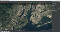
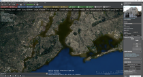
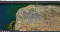
thanks, please let me know if there is a fix or improvement. I would gladly follow it. This is how I see it with BMNG layer and LAnd cover (yellow/red one). There is heavy pixelation in the borders of the Balearic islands (mediterranean sea), and for the LAnd Cover layer, it is completely pixelated.
- Attachments
-
- cmno4.png (1.53 MiB) Viewed 561 times
-
- cmo3.png (2.5 MiB) Viewed 561 times
-
- cmo2.png (1.74 MiB) Viewed 561 times