

Africa Bitmaps
Moderator: Shannon V. OKeets
RE: Africa Bitmaps
A bit too late in the process probably... but shouldn't the Algerian city of Oran be a city in MWiF. Population in 1936 totalled about 195k. Maybe even the city of Constantine deserves to be included with a population of 107k in 1936 and also an important HQ for the Allies during the desert war. However the 100k limit perhaps is not that applicable because it would also include the Moroccan cities of Fez (144k) and Marrakech (190k). But considering that the Egyptian cities of Aswan (22k) and Asyut (60k) are included as cities, shouldn't at least Oran deserve to be upgraded to a city?
- Attachments
-
- 1.jpg (166.28 KiB) Viewed 687 times
-
Shannon V. OKeets
- Posts: 22165
- Joined: Wed May 18, 2005 11:51 pm
- Location: Honolulu, Hawaii
- Contact:
RE: Africa Bitmaps
Not too late - though the justification for changes has to be more pronounced than it would have been earlier.ORIGINAL: ahlner
A bit too late in the process probably... but shouldn't the Algerian city of Oran be a city in MWiF. Population in 1936 totalled about 195k. Maybe even the city of Constantine deserves to be included with a population of 107k in 1936 and also an important HQ for the Allies during the desert war. However the 100k limit perhaps is not that applicable because it would also include the Moroccan cities of Fez (144k) and Marrakech (190k). But considering that the Egyptian cities of Aswan (22k) and Asyut (60k) are included as cities, shouldn't at least Oran deserve to be upgraded to a city?
The 100,000 population is a minimum, with cities smaller than that excluded (unless very special circumstances are present). Simply because the population was more than 100,000 did not mean the city would be included. For example, there are several countries that have numerous cities that large or larger in close proximity. The map would just be a cluster of city hexes under those circumstances - England and Germany are close to that already.
But a more definite reason for not changing Oran's status is that we want to stay as true to WIF FE as possible. That means any hexes that are on the WIF FE European map are pretty much sacrosanct ("Thou shalt not change!"). With fearful looks over our shoulder, we did change a few things in southern Scandinavia, but otherwise, we tred "oh so lightly" in making changes in Europe and Northern Africa.
Steve
Perfection is an elusive goal.
Perfection is an elusive goal.

RE: Africa Bitmaps
I lived south of Oran when I was a kid (place called Sidi-Bel-Abbes - also once the French Foreign Legion's Main HQ  ). Commuted from Tlemcen (a hex or two to the West of the crossing of rail lines that had some nifty Roman ruins) and the hills were a bit jagged, but not overly high, and the roads clung to the hill (you'd go 20KM just to go 10KM as the crow flies). There was a new highway they were building at the time in the valley north of the mountains, but it kept washing away......
FWIW, I'm happy with the way the terrain is in this area- and changing things on the European map (as printed) should be done very, very carefully, as Shannon said.....
I for one can't wait to get to take a "scroll" around the map......
dsrgames.blogspot.com
FWIW, I'm happy with the way the terrain is in this area- and changing things on the European map (as printed) should be done very, very carefully, as Shannon said.....
I for one can't wait to get to take a "scroll" around the map......
dsrgames.blogspot.com
-
Largus_Means

- Posts: 25
- Joined: Thu Jun 10, 2004 1:45 am
RE: Africa Bitmaps
ORIGINAL: Shannon V. OKeets
Nag, nag, nag, ...[;)]ORIGINAL: FroonpSure, as always.I believe there are two entries for this name: as a 'minor country' and as a label for the map. The program doesn't care about the later, but the former is referenced internally. So let me know if you change the name in the minor country CSV file.
Also PLEAAAAAASE, show us the north western Africa, where it joins with Morocco [&o] [&o] [&o] [&o]
Canary Islands are done but not the Madeira Islands. The hex SW of Mogador has suffered a shark attack (big shark).

Dregging some old stuff up here, and hope Im not going into realms that cannot be changed, if so I will cease and move on to other areas of discussion.
The resource south of Oran is probably called Colomb Bechar or maybe even Abadla, if you wish it to be named.
Also the question is once again raised, in that is being historical or true to WiF:FE more important with the maps? How greatly do small changes/improvements make on the over all feel of things. For example, tte rail lines along this coast are correct, but could be slightly changed to represent the off shoots of the main line, that travel north to the coast. But there are some other lines that were not included and would have had an impact on this area and moving supplies. ie- Marrakech, Tozeur, Djelfa.
http://history.sandiego.edu/cdr2/WW2Pics2/82022bg.jpg
Since your are travelling into the grey areas on China, Russia, India, what about the outer areas of the orginal maps that have some strange things.
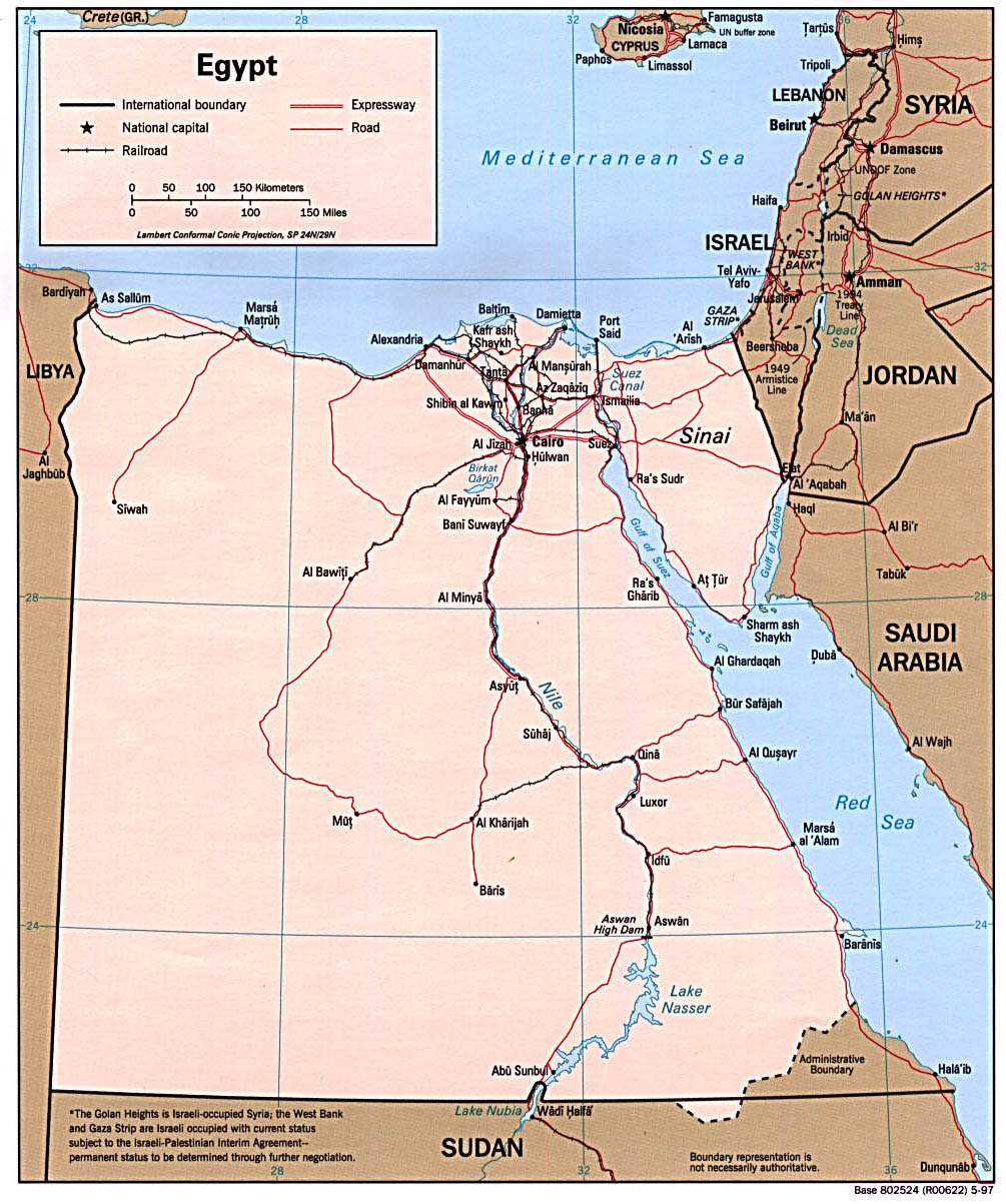
Another area, which I know will not be changed, are the rail lines in Egypt and Palestine. On maps I have of the area, the rail line extends from the Epyptian border neared Bardia to Alexandria, then turns south to Cairo and continues south. It does not cross the the canal. The closest rail line east of the canal is at Al Arish. Also there is no rail line that extends from Amman to Medina, but thats another point.
http://britains-smallwars.com/Canal/Map.htm
http://www.lib.utexas.edu/maps/africa/egypt_pol97.jpg <-- Egypt 1997
http://www.nzetc.org/tm/scholarly/WH2Ch ... hr04a.html <--- Egypt 1940
Anyway, let me know if this is a very dead horse Im beating here.
Cheers
-
Largus_Means
- Posts: 25
- Joined: Thu Jun 10, 2004 1:45 am
RE: Africa Bitmaps
Very confused now, 4 different links, not one is even remotely the same. A very difficult task. Even more kudos to Froonp for his map work then.
http://history.sandiego.edu/cdr2/WW2Pics2/81814.jpg
Cheers
http://history.sandiego.edu/cdr2/WW2Pics2/81814.jpg
Cheers

RE: Africa Bitmaps
I've named it "Béchar" on the MWiF map. The screenshot you quoted do not show it, because it was added latter.ORIGINAL: Largus_Means
The resource south of Oran is probably called Colomb Bechar or maybe even Abadla, if you wish it to be named.
Well, you're right, and I would add this railway going from Casablanca to the south, and then east to Marrakech, but I prefer to leave those places alone, trusting the original WiF FE designer who drew the European scaled map in the first place. If he did not draw a railway there, there must be a reason. USSR, China & India are different thing, they are affected by the scale effect, going from WiF FE Pacific Map scale to WiF FE European Scale (that is the worldwide scale).Also the question is once again raised, in that is being historical or true to WiF:FE more important with the maps? How greatly do small changes/improvements make on the over all feel of things. For example, tte rail lines along this coast are correct, but could be slightly changed to represent the off shoots of the main line, that travel north to the coast. But there are some other lines that were not included and would have had an impact on this area and moving supplies. ie- Marrakech, Tozeur, Djelfa.
http://history.sandiego.edu/cdr2/WW2Pics2/82022bg.jpg
Since your are travelling into the grey areas on China, Russia, India, what about the outer areas of the orginal maps that have some strange things.
No dead horse here, but the European part of the WiF FE maps is not touched unless big errors are spotted (as were revealed in Scandinavia).Another area, which I know will not be changed, are the rail lines in Egypt and Palestine. On maps I have of the area, the rail line extends from the Epyptian border neared Bardia to Alexandria, then turns south to Cairo and continues south. It does not cross the the canal. The closest rail line east of the canal is at Al Arish. Also there is no rail line that extends from Amman to Medina, but thats another point.
http://britains-smallwars.com/Canal/Map.htm
http://www.lib.utexas.edu/maps/africa/egypt_pol97.jpg <-- Egypt 1997
http://www.nzetc.org/tm/scholarly/WH2Ch ... hr04a.html <--- Egypt 1940
Anyway, let me know if this is a very dead horse Im beating here.
Other learned and enlightened comments, especially about the murkiest parts of the map, are welcomed.
RE: Africa Bitmaps
Not sure if this area is considered 'finished', but I thought I'd toss in a bit of rail info.
According to several maps I have and also according to this map:
http://www.military.com/Resources/Resou ... erview.htm
There are several rail lines in Eastern Algeria and Central Tunisia which aren't on the MWiF maps. They all exist pre-1938.
Firstly, from Sousse through Kasserine Pass is a line that continues all the way past Gafsa to Tazeur in the salt marshes. This would run from Sousse on the coast 1 hex west, then 1 hex south west, then 1 hex west again then 2 further hexes south west to the far western swamp hex. Kasserine Pass would be the second last hex on the line, just NE of the west swamp hex.
This rail line was one of the major reasons for the Battle of Kasserine Pass, as it would have allowed the Germans to outflank American positions in Algeria to the west, and they in fact attempted this very thing resulting in the well known Battle.
Secondly, on the Algerian side of the border is the line that runs from Bone to Tebessa and another from Algiers to Tebessa. Again this rail line was of importance as it outflanked German positions in Tunisia, and was the reason for the American push into the interior of Tunisia. This line would run from Bone to Tebessa (hex 1008 on WiF map) which is one hex NW of Kasserine. A second line would split off half way between Algiers and Bone and head southeast towards Tebessa.
Tebessa was the main American railhead for the attacks on central Tunisia and was the launching point for their attacks towards Kasserine Pass.
The most important thing about these railways is that they allow supply and flanking combat through central Tunisia and not just supply on the coast. This would be historical as their were quite a few attacks here while jockying for position for the push to (and defence of) Tunis.
http://www.military.com/Resources/Resou ... erview.htm and
http://www.military.com/Resources/Resou ... erview.htm - also shows the number of attacks and defences that were based around these 2 railroads.
-------------
C.L.Norman
C.L.Norman
RE: Africa Bitmaps
Any comments on this?
It would be a shame to have an area that was intensely fought over be poorly portrayed. As it stands right now, there is no reason at all to campaign to control Central Tunisia to outflank the coastal routes like there was historically.
The change to the rail lines wouldn't overly change the war in Africa, nor would it be a major change to the sacred Euro Map, but it would bring a much more accurate portrayal to this front. The battles fought in Central Tunisia were the largest of the entire African Campaign (including Alamien) in total forces involved.
Have a look at the maps I linked and see what you think. The third map especially shows the forces that were arrayed here and the battles that were fought for the railheads and passes. Right now its just an empty desert hex of no value whatsoever. Lets have Kasserine Pass be as critical as it historically was.
.
-------------
C.L.Norman
C.L.Norman
-
Shannon V. OKeets
- Posts: 22165
- Joined: Wed May 18, 2005 11:51 pm
- Location: Honolulu, Hawaii
- Contact:
RE: Africa Bitmaps
I let Patrice work out 98% of the map decisions based on comments from the rest of the forum. I, myself, know very little about the railroads in Tunisia in WW II.ORIGINAL: Norman42
Any comments on this?
It would be a shame to have an area that was intensely fought over be poorly portrayed. As it stands right now, there is no reason at all to campaign to control Central Tunisia to outflank the coastal routes like there was historically.
The change to the rail lines wouldn't overly change the war in Africa, nor would it be a major change to the sacred Euro Map, but it would bring a much more accurate portrayal to this front. The battles fought in Central Tunisia were the largest of the entire African Campaign (including Alamien) in total forces involved.
Have a look at the maps I linked and see what you think. The third map especially shows the forces that were arrayed here and the battles that were fought for the railheads and passes. Right now its just an empty desert hex of no value whatsoever. Lets have Kasserine Pass be as critical as it historically was.
.
Steve
Perfection is an elusive goal.
Perfection is an elusive goal.
RE: Africa Bitmaps
Yes, I saw that, and I knew that there were more railways on the maps that we see on the WiF FE map, but as it is the Europe map, we prefer not to touch it too much. There are other changes in Magrheb that I refrain from doing. Adding Fez (144k inhabitants during the war) as a city, adding railways down to Marakech, eventualy moving Casablanca & Mogador a couple of hexes southward, adding Constantine (114k inhabitants during the war) as a city, extending the Algerian railway stubs (I added them, but shorter) to their real length, adding the railways in Tunisia...ORIGINAL: Norman42
Any comments on this?
It would be a shame to have an area that was intensely fought over be poorly portrayed. As it stands right now, there is no reason at all to campaign to control Central Tunisia to outflank the coastal routes like there was historically.
The change to the rail lines wouldn't overly change the war in Africa, nor would it be a major change to the sacred Euro Map, but it would bring a much more accurate portrayal to this front. The battles fought in Central Tunisia were the largest of the entire African Campaign (including Alamien) in total forces involved.
Have a look at the maps I linked and see what you think. The third map especially shows the forces that were arrayed here and the battles that were fought for the railheads and passes. Right now its just an empty desert hex of no value whatsoever. Lets have Kasserine Pass be as critical as it historically was.
.
But, there are things that must be handled with care, and railways are amongst them. For example, seeing railways on the map not always means that they can be used for military needs as we use them in WiF FE. Were they in good shape enough ? Were they the right gauge ? I don't even know what other question might be considered to say it is OK. Here I prefer to trust the original WiF FE designer, and not add more railways.
This said, I added your comments to the list of proposed changes, so that they are not forgotten if one day we decide to break the holy vow (joke) of not touching the European map.
RE: Africa Bitmaps
Railroads in North Africa were indeed serviceable but capacity was very limited. Generally enough to move and supply a couple of divisions, certainly not corps and armies.
Of course, both sides shipped locomotives and other equipments from Europe. But it was impossible to reach high capacity levels without long-term investments.
NB: within the DOD time frame (not MWiF product 1), such investments could be an option. For instance, one project was a Tripoli to Benghazi railroad. During the war "240km were surveyed, picketted and levelled". However, it seems no track was laid down before the project was abandoned.
RE: Africa Bitmaps
North African cities. In the game, cities are mostly useful for reinforcements (not applicable in French North Africa) and ground defense (buildings help the defender).
Population is a good indicator of the number of buildings in a city. But for war purpose, a 144k city in North Africa is probably not equal to a 144k city in Europe: buildings were not as solid as European ones (and there were perhaps less buildings).
Population is a good indicator of the number of buildings in a city. But for war purpose, a 144k city in North Africa is probably not equal to a 144k city in Europe: buildings were not as solid as European ones (and there were perhaps less buildings).
RE: Africa Bitmaps
eventualy moving Casablanca & Mogador a couple of hexes southward
Why not (if the mistake is obvious).
RE: Africa Bitmaps
Exactly what I was also assuming.ORIGINAL: jcprom
North African cities. In the game, cities are mostly useful for reinforcements (not applicable in French North Africa) and ground defense (buildings help the defender).
Population is a good indicator of the number of buildings in a city. But for war purpose, a 144k city in North Africa is probably not equal to a 144k city in Europe: buildings were not as solid as European ones (and there were perhaps less buildings).
RE: Africa Bitmaps
ORIGINAL: jcprom
North African cities. In the game, cities are mostly useful for reinforcements (not applicable in French North Africa) and ground defense (buildings help the defender).
And territorial reinforcement placement/supply, and rail movement terminus, and, well, as targets to fight over. Capturing Algiers, or Benghazi is far more interesting then capturing empty hex 1804 and 1189.
-------------
C.L.Norman
C.L.Norman
-
Shannon V. OKeets
- Posts: 22165
- Joined: Wed May 18, 2005 11:51 pm
- Location: Honolulu, Hawaii
- Contact:
RE: Africa Bitmaps
Uh-oh[X(], don't get Patrice started or he might start naming every oasis in Africa.[:D]ORIGINAL: Norman42
ORIGINAL: jcprom
North African cities. In the game, cities are mostly useful for reinforcements (not applicable in French North Africa) and ground defense (buildings help the defender).
And territorial reinforcement placement/supply, and rail movement terminus, and, well, as targets to fight over. Capturing Algiers, or Benghazi is far more interesting then capturing empty hex 1804 and 1189.
Steve
Perfection is an elusive goal.
Perfection is an elusive goal.
RE: Africa Bitmaps
Capturing Algiers, or Benghazi is far more interesting then capturing empty hex 1804 and 1189.
Yes, having names on the map would add flavor to the game: Mareth line? Kasserine? Mers-el-Kébir? Halfaya pass? cities like Fez? areas (Cyrenaica is shown)?
-
jesperpehrson
- Posts: 848
- Joined: Sat Jul 29, 2006 4:48 pm
RE: Africa Bitmaps
ORIGINAL: jcprom
Capturing Algiers, or Benghazi is far more interesting then capturing empty hex 1804 and 1189.
Yes, having names on the map would add flavor to the game: Mareth line? Kasserine? Mers-el-Kébir? Halfaya pass? cities like Fez? areas (Cyrenaica is shown)?
Oh and the "Devils Bathtub"! (Shott-al-Jerid)
EDIT: I think I even posted a picture of that here somewhere
PBEMgames played
- Korea 50-51 MV as communist
- Agonia y Victoria xx as Republican
- Plan Blau OV as Soviet
- The great war xx as Central Powers
- DNO XX as Soviet
- Korea 50-51 MV as communist
- Agonia y Victoria xx as Republican
- Plan Blau OV as Soviet
- The great war xx as Central Powers
- DNO XX as Soviet
RE: Africa Bitmaps
ORIGINAL: Froonp
adding the railways in Tunisia...
But, there are things that must be handled with care, and railways are amongst them...
This said, I added your comments to the list of proposed changes, so that they are not forgotten if one day we decide to break the holy vow (joke) of not touching the European map.
I think part of the underlying problem of Tunisia in particular is not just the railways, but the terrain itself.
The entire Eastern and Western Dorsal Ranges are missing completely from Algeria/Tunisia. They are currently empty desert hexes when in fact they should be a mountain range. Kasserine Pass was really a *pass* through the Dorsal Range and is what made it important (which is why the railways went both there and to Tebessa on the far side of the pass). Control of the passes (there were 3, but only Kasserine was considered an all weather road) equalled control of Central Tunisia.
If the railroads cannot be added, perhaps at least look at adding 4 or 5 mountain hexes(not all desert mountain, the northern Dorsals often had torrential rainfall turning the area into 5 foot deep mud) to the area with Kasserine as a gap between them. Then at least the terrain is accurate and the value of Kasserine on map makes some sense instead of being one of 15 hexes of empty Tunisian desert.
Note: my suggestion would be to make hexes 1009 and 0909 mountains, label hex 0908 as Kasserine, and make the line of 1108, 1107, and 1007 desert mountains to represent the Western Dorsals.
.
-------------
C.L.Norman
C.L.Norman
RE: Africa Bitmaps
Look, I'm not at all planning on changing this area, because it is on the Europe Map, and because the railways are maybe not warranted, and also because the mountain hexes themselves are not really warranted either. This looks more like rolling hills or broken terrain than mountains. But I made a draft drawing to try to show what you did put into words. I vastly prefer a crude draft than a long explanation.ORIGINAL: Norman42
I think part of the underlying problem of Tunisia in particular is not just the railways, but the terrain itself.
The entire Eastern and Western Dorsal Ranges are missing completely from Algeria/Tunisia. They are currently empty desert hexes when in fact they should be a mountain range. Kasserine Pass was really a *pass* through the Dorsal Range and is what made it important (which is why the railways went both there and to Tebessa on the far side of the pass). Control of the passes (there were 3, but only Kasserine was considered an all weather road) equalled control of Central Tunisia.
If the railroads cannot be added, perhaps at least look at adding 4 or 5 mountain hexes(not all desert mountain, the northern Dorsals often had torrential rainfall turning the area into 5 foot deep mud) to the area with Kasserine as a gap between them. Then at least the terrain is accurate and the value of Kasserine on map makes some sense instead of being one of 15 hexes of empty Tunisian desert.
Note: my suggestion would be to make hexes 1009 and 0909 mountains, label hex 0908 as Kasserine, and make the line of 1108, 1107, and 1007 desert mountains to represent the Western Dorsals.
Also, I added other railways that you did not describe, but that are present on maps of the time.

- Attachments
-
- TunisiaA..n42copy.jpg (182.97 KiB) Viewed 687 times