

Would it be possible to pick an interesting area, say Berlin or Shanghai or some such and show the screen shot at all 8 levels of zoom?
Thanks,
MWiF Map Review - India & Burma
Moderator: Shannon V. OKeets
RE: MWiF Map Review - India & Burma
Steve Balk
Iowa, USA
Iowa, USA
RE: MWiF Map Review - India & Burma
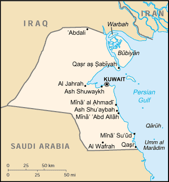
Kuwait seems way to big, unless the borders were different during WW2.
Map: http://en.wikipedia.org/wiki/Image:Ku-map.gif
How about changing these hexes to become saudi:
-desert SW of Kuwait
-desert W+W of Kuwait
-desert W + NW of Kuwait
Map: http://en.wikipedia.org/wiki/Image:Ku-map.gif
How about changing these hexes to become saudi:
-desert SW of Kuwait
-desert W+W of Kuwait
-desert W + NW of Kuwait
-
Shannon V. OKeets
- Posts: 22165
- Joined: Wed May 18, 2005 11:51 pm
- Location: Honolulu, Hawaii
- Contact:
RE: MWiF Map Review - India & Burma
I just did that for you in another thread.ORIGINAL: sajbalk
Would it be possible to pick an interesting area, say Berlin or Shanghai or some such and show the screen shot at all 8 levels of zoom?
Thanks,
Steve
Perfection is an elusive goal.
Perfection is an elusive goal.

RE: MWiF Map Review - India & Burma
Your quoted map :ORIGINAL: Incy
Kuwait seems way to big, unless the borders were different during WW2.
Map: http://en.wikipedia.org/wiki/Image:Ku-map.gif
How about changing these hexes to become saudi:
-desert SW of Kuwait
-desert W+W of Kuwait
-desert W + NW of Kuwait
What you propose looks like that.
I must say that the distances and proportions and positions of the borders, especially the Iraqi one, seem better. Opinions ?

- Attachments
-
- Kuwait.jpg (168.47 KiB) Viewed 451 times
RE: MWiF Map Review - India & Burma
I measured Kuwait on Google Earth, and it is about 170 km north-south and 170 km east-west, so maybe this new depiction is better.ORIGINAL: Froonp
ORIGINAL: Incy
Kuwait seems way to big, unless the borders were different during WW2.
Map: http://en.wikipedia.org/wiki/Image:Ku-map.gif
How about changing these hexes to become saudi:
-desert SW of Kuwait
-desert W+W of Kuwait
-desert W + NW of Kuwait
What you propose looks like that.
I must say that the distances and proportions and positions of the borders, especially the Iraqi one, seem better. Opinions ?
RE: MWiF Map Review - India & Burma
I think the new Kuwait more closely resembles the historical country.
One interesting thing with the new map scale is that conquering Saudi Arabia, even against the puny 1-5 CAV is a 2 HQ operation for regular supply.
One interesting thing with the new map scale is that conquering Saudi Arabia, even against the puny 1-5 CAV is a 2 HQ operation for regular supply.
Steve Balk
Iowa, USA
Iowa, USA
RE: MWiF Map Review - India & Burma
I'm happy this kind of effect happens. Saudi Arabian is a hell of a large and hot country. At least, it seems so by looking at maps.ORIGINAL: sajbalk
I think the new Kuwait more closely resembles the historical country.
One interesting thing with the new map scale is that conquering Saudi Arabia, even against the puny 1-5 CAV is a 2 HQ operation for regular supply.
RE: MWiF Map Review - India & Burma
ORIGINAL: Froonp
I must say that the distances and proportions and positions of the borders, especially the Iraqi one, seem better. Opinions ?
New Kuwait looks better.
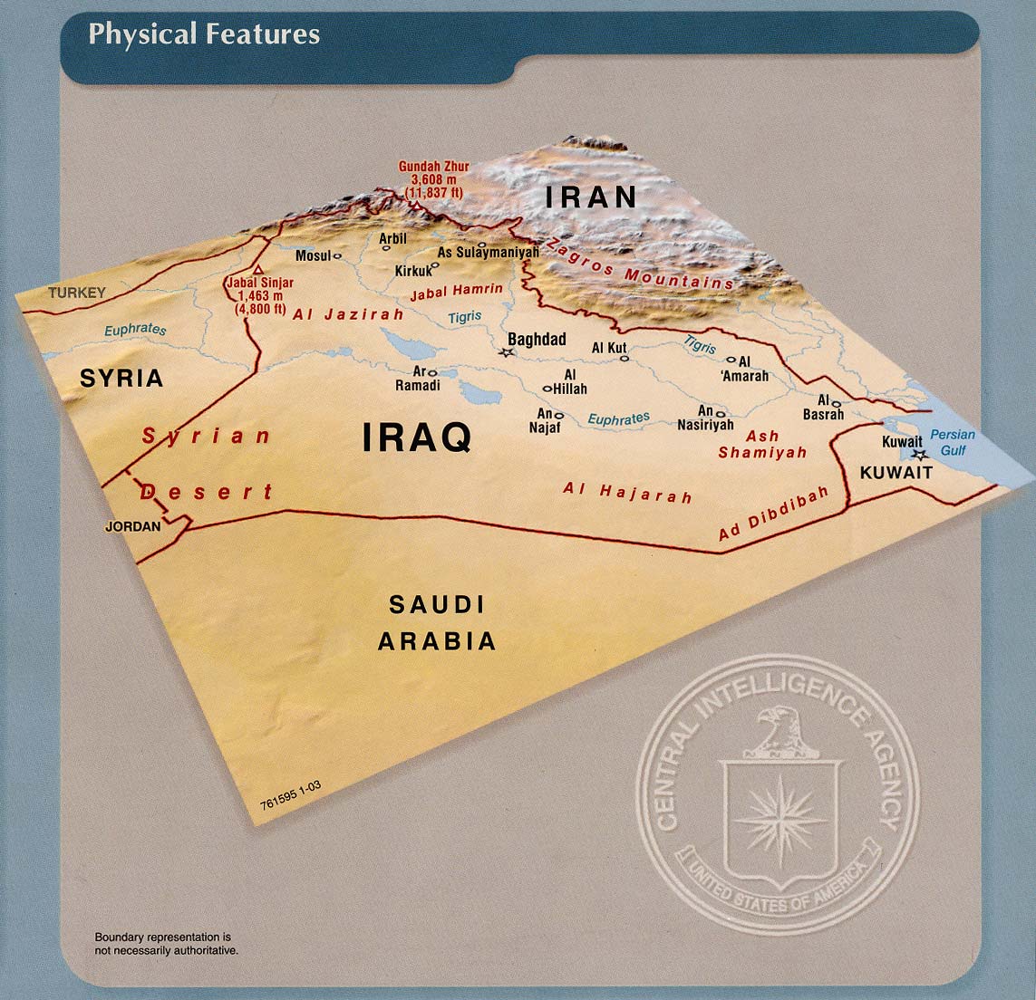
I have found another Middle East problem.
Iraq.
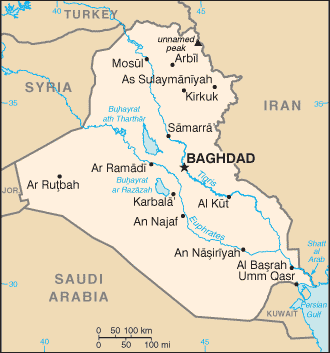
It is much too thin East>West. Look at it on google map and it becomes plain to see.
The problem is the 4 border mountain hexes in Persia that stick into Iraq east of Baghdad(you can see the southern 2 hexes on the north edge of Patrice's map above). They are wrong; one even touches the Tigris River. In reality the border of Persia is nowhere near the Tigris, it is over one hundred miles east. This problem most likely stems from the old "edge-of-the-map warped Iraq/Persia" that we had issues with before.
I propose that the 4 mountain hexes of Persia from the one that touches the Tigris north of Basra continuing 4 mountain hexes north along the border be changed to Iraq.
This would be far more accurate of a border.
-------------
C.L.Norman
C.L.Norman
RE: MWiF Map Review - India & Burma
Iraq is a problem since the start, and I knew that it was slightly too narrow.ORIGINAL: Norman42
I have found another Middle East problem.
Iraq.
It is much too thin East>West. Look at it on google map and it becomes plain to see.
The problem is the 4 border mountain hexes in Persia that stick into Iraq east of Baghdad(you can see the southern 2 hexes on the north edge of Patrice's map above). They are wrong; one even touches the Tigris River. In reality the border of Persia is nowhere near the Tigris, it is over one hundred miles east. This problem most likely stems from the old "edge-of-the-map warped Iraq/Persia" that we had issues with before.
I propose that the 4 mountain hexes of Persia from the one that touches the Tigris north of Basra continuing 4 mountain hexes north along the border be changed to Iraq.
This would be far more accurate of a border.
But I'm reluctant to change it too much because I fear that this would causes more problems eastwards.
The problem is that Iraq was in the middle of the European & Asia maps, so it was made up of a part in European map that was already distorded, and from an Asian part that is constrained by the rest of the Asia map. It is kind of a point of constriction that we can't avoid. If we touch Iraq too much, won't we need to touch Persia, and then Afghanistan, etc... I'm loathe to do this because it would also need to redraw rivers, lakes, even seas. So we need to be careful here.
Maybe I can only change the 2 southernmost mountains hexes to Persia ?
That would look good to me. See the attached map.

Compare it to that map :
- Attachments
-
- IraqKuw..07191s.jpg (179.63 KiB) Viewed 451 times
RE: MWiF Map Review - India & Burma
Problem is that, as you can see here :
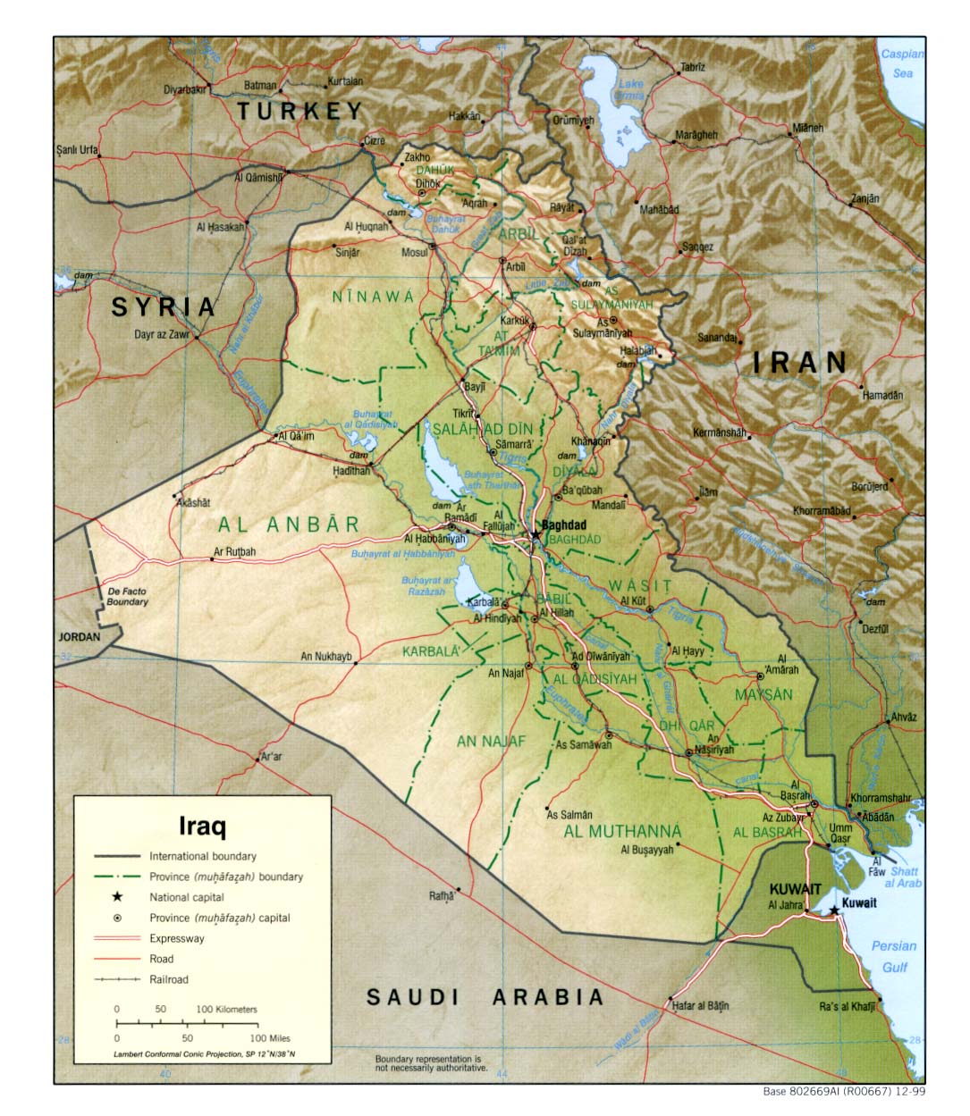
The terrain is nowhere as mountanous in that eastern part of Iraq as we show it on the MWiF map now (post just above).
So we need to elimitate those 3 mountain hexes north of the Tigris, and the 3 alpine hexsides that go with them.
And now, if we do that, this is an hexrow less in the Zagros Mountains. Are they still well depicted ?
What terrain do we give those changed mountain hexes ? Desert ?
-
Sewerlobster

- Posts: 330
- Joined: Sun May 06, 2007 10:40 pm
- Location: Reading, Pa. USA
RE: MWiF Map Review - India & Burma
Looking at that map and MWif's I agree the three mountain hexes should go. And as Patrice's map depicts the area just west of the mountains as green and not tan, I'd lean toward open over desert; just like the hexes around the Nile. But I'd understand the choice of desert as an appropriate "ruggedness" for the terrain.ORIGINAL: Froonp
Problem is that, as you can see here : <Map Deleted by SewerStarFish>
The terrain is nowhere as mountanous in that eastern part of Iraq as we show it on the MWiF map now (post just above).
So we need to elimitate those 3 mountain hexes north of the Tigris, and the 3 alpine hexsides that go with them.
And now, if we do that, this is an hexrow less in the Zagros Mountains. Are they still well depicted ?
What terrain do we give those changed mountain hexes ? Desert ?
Why choose the lesser evil: Vote Cthulhu.
RE: MWiF Map Review - India & Burma
If I remember correctly each hex in MWIF is around 90 km. And with 90 km a hex I have no trouble with Tigris being close to Iran. Tigris looks to me to be about 30 km from the irianian border when it is closest. I would suggest redrawing Tigris so that it don't cross over into Iran.
I agree that Iraq looks way to narrow east - west. But to me it looks like a better solution to take a few hexes from Saudi Arabia.
According to the nice map it looks like several desert hexes should be change to Iraq from Saudi Arabia.
-Orm
I agree that Iraq looks way to narrow east - west. But to me it looks like a better solution to take a few hexes from Saudi Arabia.
According to the nice map it looks like several desert hexes should be change to Iraq from Saudi Arabia.
-Orm
Have a bit more patience with newbies. Of course some of them act dumb -- they're often students, for heaven's sake. - Terry Pratchett
A government is a body of people; usually, notably, ungoverned. - Quote from Firefly
A government is a body of people; usually, notably, ungoverned. - Quote from Firefly
RE: MWiF Map Review - India & Burma
ORIGINAL: Froonp
Maybe I can only change the 2 southernmost mountains hexes to Persia ?
That would look good to me. See the attached map.
Compare it to that map :
This looks better Patrice.
I do think those 2 hexes should be changed, and also make them not mountains anymore, perhaps desert instead.
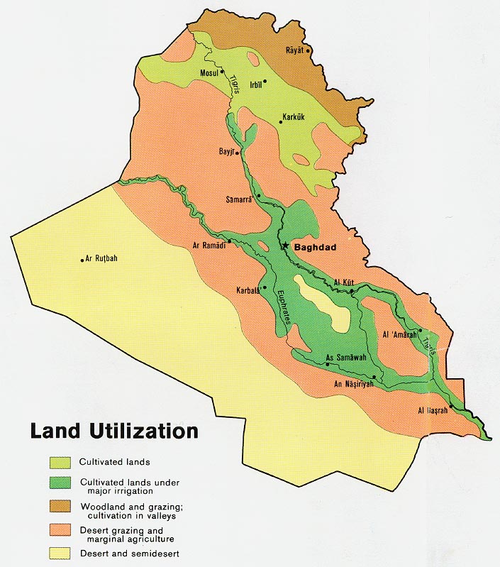
Actually I'm not sure why the area between the Tigris and Euphrates river is desert. This is in reality a very lush area, fully irrigated and criss-crossed by small rivers. It's not called the Fertile Crescent for nothing!
I propose to change those 2 mountain hexes to desert, and the 4 desert hexes between the rivers to clear.
Edit: It wouldn't hurt to take a couple hexes from Saudi Arabia either, as Paul mentions above, to "fatten up" Iraq.
-------------
C.L.Norman
C.L.Norman
RE: MWiF Map Review - India & Burma
ORIGINAL: Shannon V. OKeets
15th in series - due east of the previous post.

Shouldn't the desert thats in Tibet/China be desert mountain?
Not that this area will ever, ever, ever see activity (if anyone ever gets a unit there, please post a pic!) but it does seem odd to have a small Sahara Desert in the Himalayas.
-------------
C.L.Norman
C.L.Norman
RE: MWiF Map Review - India & Burma
I'm not suprised by such terrain here. I suppose this represents the desertic plateau of the Tibet highlands.ORIGINAL: Norman42
Shouldn't the desert thats in Tibet/China be desert mountain?
Not that this area will ever, ever, ever see activity (if anyone ever gets a unit there, please post a pic!) but it does seem odd to have a small Sahara Desert in the Himalayas.
I've never been there, but I've seen pictures of tibets that makes me think those hexes are not wrong.
RE: MWiF Map Review - India & Burma
Regarding Iraq if we are going to use the map picture to get a better representation of the country then I think we also have to adjust its other borders. If we use the rivers Euphrates and Tigris to guage things then I think we would need to move the borders as below?
Also in the map of the horn of Africa (Ethipoia/Somaliland/Aden - post 84 above?) why is the font for the label Italian Somaliland larger than British Somaliland? Can it be reduced to the same size?

Also in the map of the horn of Africa (Ethipoia/Somaliland/Aden - post 84 above?) why is the font for the label Italian Somaliland larger than British Somaliland? Can it be reduced to the same size?
- Attachments
-
- Iraq.jpg (170.43 KiB) Viewed 451 times
RE: MWiF Map Review - India & Burma
Sorry but as usual I posted too hastily and did not check things properly. It is the FRENCH Somaliland label I think that needs reduced not the Italian one as I posted.
RE: MWiF Map Review - India & Burma
ORIGINAL: Plain Ian
Also in the map of the horn of Africa (Ethipoia/Somaliland/Aden - post 84 above?) why is the font for the label Italian Somaliland larger than British Somaliland? Can it be reduced to the same size?
British Somaliland is a Territory (WiF definition) and Italian Somaliland and French Somaliland are Minor Countries (WiF definition). Minor countries are all written with the same font, and Territories too, smaller than Territories. All is consistent here.ORIGINAL: Plain Ian
Sorry but as usual I posted too hastily and did not check things properly. It is the FRENCH Somaliland label I think that needs reduced not the Italian one as I posted.
RE: MWiF Map Review - India & Burma
I say your drawing is not that bad.ORIGINAL: Plain Ian
Regarding Iraq if we are going to use the map picture to get a better representation of the country then I think we also have to adjust its other borders. If we use the rivers Euphrates and Tigris to guage things then I think we would need to move the borders as below?
What do others think ?
RE: MWiF Map Review - India & Burma
I like the new, fatter Iraq, but I cannot see that it will make too much difference in the game. Also, no mountains should be next to the rivers. Finally, at least now, the area in between the 2 rives should not be desert. I would suggest normal terrain.
See http://www.globalsecurity.org/military/ ... errain.gif
Maybe some swamp, given the above site's concerns.
Also: http://www.lib.utexas.edu/maps/middle_e ... t_2003.jpg
Finally: http://www.lib.utexas.edu/maps/middle_e ... d_1978.jpg
See http://www.globalsecurity.org/military/ ... errain.gif
Maybe some swamp, given the above site's concerns.
Also: http://www.lib.utexas.edu/maps/middle_e ... t_2003.jpg
Finally: http://www.lib.utexas.edu/maps/middle_e ... d_1978.jpg
Steve Balk
Iowa, USA
Iowa, USA