

EDIT: In reply to Sardaukar (timtom was faster)
No, your confusing the Chindwin River with the Irrawaddy, and the Irrawaddy with the Doktawaddy.
Chindwin: river south of Imphal.
Irrawaddy: from Myitkyina to Mandalay.
Doktawaddy: from Lashio to Mandalay (not on the map).
CHS: Mandalay on the wrong side of the river?
Moderators: wdolson, Don Bowen, mogami

-
Kereguelen

- Posts: 1474
- Joined: Wed May 12, 2004 9:08 pm
RE: CHS: Mandalay on the wrong side of the river?
ORIGINAL: VSWG
EDIT: In reply to Sardaukar (timtom was faster)
No, your confusing the Chindwin River with the Irrawaddy, and the Irrawaddy with the Doktawaddy.
Chindwin: river south of Imphal.
Irrawaddy: from Myitkyina to Mandalay.
Doktawaddy: from Lashio to Mandalay (not on the map).
Seems that this is correct, problem is that the whole Burma area is wrong as it is on the CHS map: Myitkina should be one hex NE of its present location and all five bases from Imphal to Ledo should be one hex NW of their present locations. The Chindwin should part from the Irrawaddy one hex W and the Irawaddy should be moved to the new location of Myitkina and the Doktawaddy/Myitnge river should "cover" Mandalay but only be one hex in length.

RE: CHS: Mandalay on the wrong side of the river?
More for Andrew Brown to fix...[:D][8D]
"To meaningless French Idealism, Liberty, Fraternity and Equality...we answer with German Realism, Infantry, Cavalry and Artillery" -Prince von Bülov, 1870-


RE: CHS: Mandalay on the wrong side of the river?
ORIGINAL: Sardaukar
More for Andrew Brown to fix...[:D][8D]
I'd like the inclusion of Prome, Toungoo, and Shwebo [8D]

- Attachments
-
- Unavngivet.jpg (78.91 KiB) Viewed 304 times
Where's the Any key?

-
el cid again
- Posts: 16984
- Joined: Mon Oct 10, 2005 4:40 pm
RE: CHS: Mandalay on the wrong side of the river?
ORIGINAL: Sardaukar
Hmm..actually CHS map seems reasonable to me...
Really? Look at it again. It has NO river where the Irrawaddy really is - and it has a major river almost surrounding the city. In fact, the main city is East of the river, and the little river runs along the south side of the hex.
Wether or not it is a military obsticle is the question? But IF it is - it does not circle around EAST of the city - as the map shows - and there really is a river running around the NW side. Not very reasonable. I even had a comment from Matrix "how did we miss that?" No one thinks it is reasonable Ron.
-
el cid again
- Posts: 16984
- Joined: Mon Oct 10, 2005 4:40 pm
RE: CHS: Mandalay on the wrong side of the river?
ORIGINAL: Kereguelen
ORIGINAL: VSWG
EDIT: In reply to Sardaukar (timtom was faster)
No, your confusing the Chindwin River with the Irrawaddy, and the Irrawaddy with the Doktawaddy.
Chindwin: river south of Imphal.
Irrawaddy: from Myitkyina to Mandalay.
Doktawaddy: from Lashio to Mandalay (not on the map).
Seems that this is correct, problem is that the whole Burma area is wrong as it is on the CHS map: Myitkina should be one hex NE of its present location and all five bases from Imphal to Ledo should be one hex NW of their present locations. The Chindwin should part from the Irrawaddy one hex W and the Irawaddy should be moved to the new location of Myitkina and the Doktawaddy/Myitnge river should "cover" Mandalay but only be one hex in length.
This is my tentative analysis - IF the Doktawaddy is an obsticle it should be one hex in length. Working on it.
RE: CHS: Mandalay on the wrong side of the river?
I think we are gettin too much into "anal-yzes"! [:D] "It's 60-mile hex"..or so I remember the mantra...[8D] Map corrected, me all for it, tho.
"To meaningless French Idealism, Liberty, Fraternity and Equality...we answer with German Realism, Infantry, Cavalry and Artillery" -Prince von Bülov, 1870-
-
Andrew Brown

- Posts: 4088
- Joined: Tue Sep 05, 2000 8:00 am
- Location: Hex 82,170
- Contact:
RE: CHS: Mandalay on the wrong side of the river?
ORIGINAL: Gary Childress
This has probably already been discussed also but shouldn't Mandalay be on the east bank of the Irrawaddy river and not on the west? Most maps I've checked have it on the east bank. In CHS Mandalay is wedged between what look to be the Irrawaddy and Chindwin rivers.
I don't remember this being discussed before, if it was. It does look like Mandalay needs to be corrected. I probably just followed what was done with the stock map for this area, without taking a more critical look, which obviously was not a good idea! I will take a look and see what has to be fixed, but it will probably be a while before I can actually fix it.
Thanks,
Andrew
-
el cid again
- Posts: 16984
- Joined: Mon Oct 10, 2005 4:40 pm
RE: CHS: Mandalay on the wrong side of the river?
ORIGINAL: timtom
ORIGINAL: Sardaukar
More for Andrew Brown to fix...[:D][8D]
I'd like the inclusion of Prome, Toungoo, and Shwebo [8D]
I have no slots to speak of available - but by using header slots I am able to add Prome and Toungoo - which
I agree are important places - resource centers and airfields - and the reasons rail lines run to those hexes.
This is of course for RHS - Andrew does the CHS map. Note we also added a city on the coast of Burma not long
ago - explaining why the rail line runs there too. Shwebo was the ancient capital of Burma - and of some historical interest - but it is just a local center - at the intersection of the main rail line and crossing roads. It is really a suburb of Mandalay itself - actually it is less than half a hex north of the city - so you can think of it as part of the Mandalay hex.
RE: CHS: Mandalay on the wrong side of the river?
ORIGINAL: el cid again
Shwebo was the ancient capital of Burma - and of some historical interest - but it is just a local center - at the intersection of the main rail line and crossing roads. It is really a suburb of Mandalay itself - actually it is less than half a hex north of the city - so you can think of it as part of the Mandalay hex.
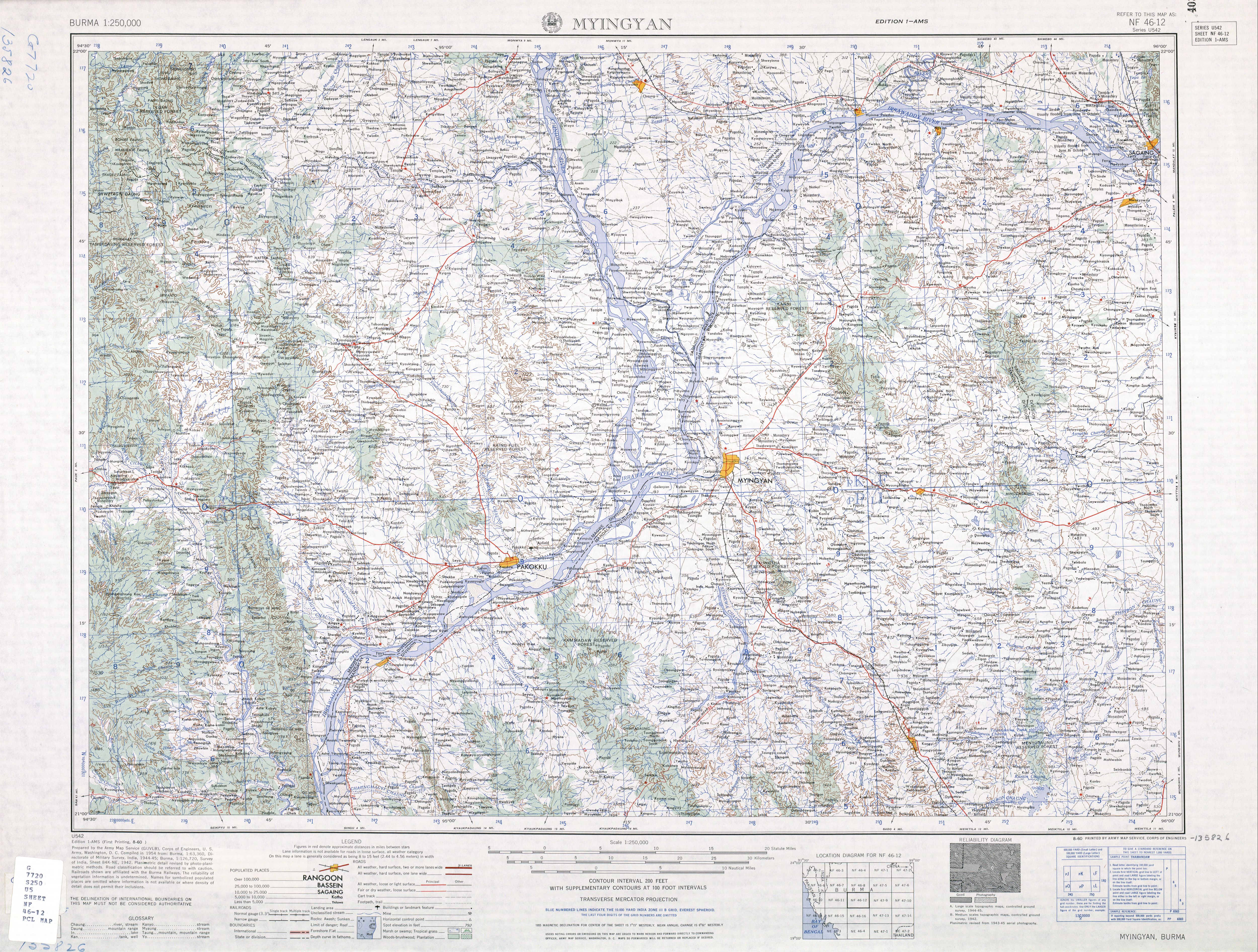
According to Wikepedia, Shwebo is 113 km (70 miles) NW of Mandalay.
http://en.wikipedia.org/wiki/Shwebo
According to the site linked below, the distance between the METAR station at Shwebo and that of Manadaly is 48.2 miles.
http://weather.gladstonefamily.net/site/48033
In the USAAF Combat Chronology, targets at or around Shwebo is mention 30 times during 1944 alone.
http://www.cbi-history.com/cbi_chronology.html
In game-terms, the inclusion of Shwebo means 1) that LCU's force-retreated out of Mandalay won't retreat towards Lashio, but in the direction of Imphal/Myitkeina instead 2) Provides an obvious location for defending the crossing of the Chindwin against attackers coming down from Imphal.

- Attachments
-
- burma.jpg (175.04 KiB) Viewed 304 times
Where's the Any key?
RE: CHS: Mandalay on the wrong side of the river?
While we're at it, isn't Zamboanga (PI) on the wrong side of the Basilan Strait?
Edit: Basilan Strait is the narrows between Zamboanga and Basilan Island on the lower map...

Edit: Basilan Strait is the narrows between Zamboanga and Basilan Island on the lower map...
- Attachments
-
- Unavngivet.jpg (39.61 KiB) Viewed 304 times
Where's the Any key?
-
DuckofTindalos

- Posts: 39781
- Joined: Fri Apr 22, 2005 11:53 pm
- Location: Denmark
RE: CHS: Mandalay on the wrong side of the river?
Remember the map isn't oriented to true North. The features look identical to me...
We are all dreams of the Giant Space Butterfly.
RE: CHS: Mandalay on the wrong side of the river?
The town of Zamboanga is on Mindanao. On Andrew's map the base named Zamboanga is located on Basilan Island with no overland access to Mindanao.
If my interpretation is correct, then either the base should be renamed, or the PwHex changed to link the base to Mindanao and (I presume) the trail extended to connect said base to central Mindanao. Ideally the map would be redraw to place Zamboanga on the Mindanao sidfe of the strait.
If my interpretation is correct, then either the base should be renamed, or the PwHex changed to link the base to Mindanao and (I presume) the trail extended to connect said base to central Mindanao. Ideally the map would be redraw to place Zamboanga on the Mindanao sidfe of the strait.
Where's the Any key?
-
el cid again
- Posts: 16984
- Joined: Mon Oct 10, 2005 4:40 pm
RE: CHS: Mandalay on the wrong side of the river?
Actually, Zamboanga is both on Mindinao and isolated from it! It is like a de facto island.
In RHS we fixed the location - and Andrew wrote he planned the same for CHS although I don't know if he has done?
But we did NOT give it a trail to the central part of the big island. However, we DID give it a trail to Jolo!
That is - a ferry service.
In RHS we fixed the location - and Andrew wrote he planned the same for CHS although I don't know if he has done?
But we did NOT give it a trail to the central part of the big island. However, we DID give it a trail to Jolo!
That is - a ferry service.
-
el cid again
- Posts: 16984
- Joined: Mon Oct 10, 2005 4:40 pm
RE: CHS: Mandalay on the wrong side of the river?
ORIGINAL: timtom
ORIGINAL: el cid again
Shwebo was the ancient capital of Burma - and of some historical interest - but it is just a local center - at the intersection of the main rail line and crossing roads. It is really a suburb of Mandalay itself - actually it is less than half a hex north of the city - so you can think of it as part of the Mandalay hex.
According to Wikepedia, Shwebo is 113 km (70 miles) NW of Mandalay.
I was looking at a map of Burma. More like 25 miles.
RE: CHS: Mandalay on the wrong side of the river?
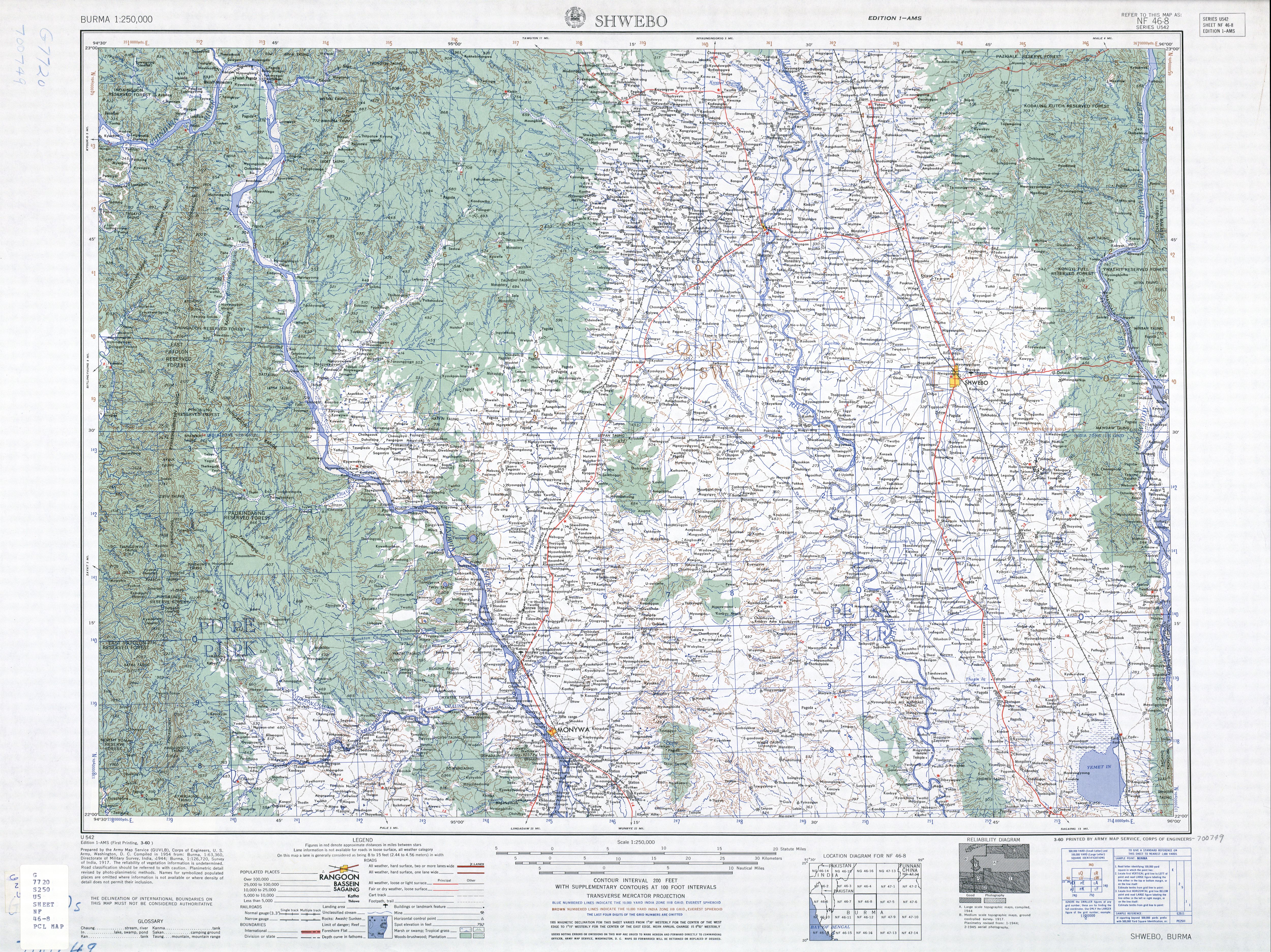
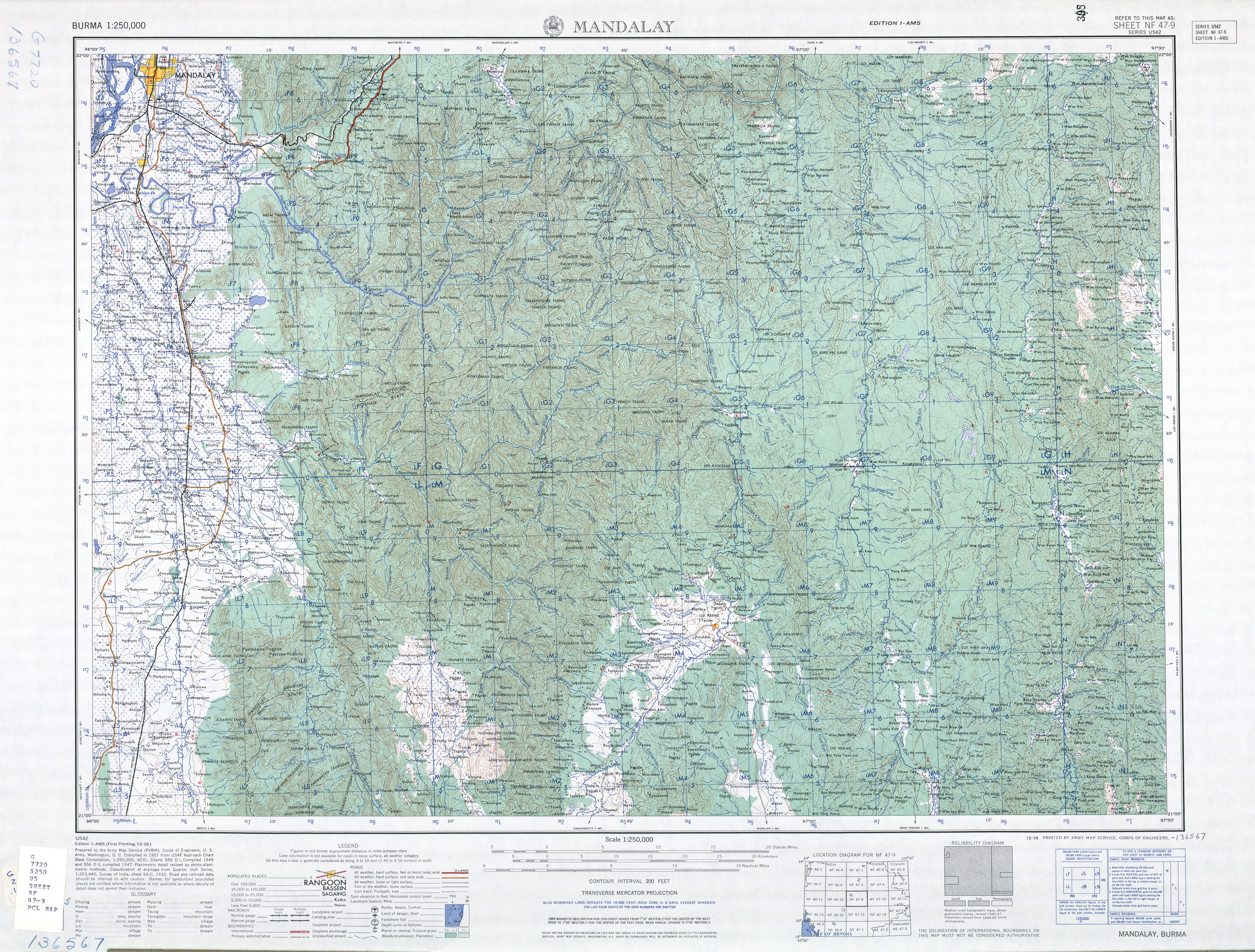
below's maps NF46-8, NF46-12, and NF47-9 from map series U542, U.S. Army Map Service, pasted together in a fashion to show the relation between Mandalay and Shwebo. Each blue grid represent 5 nautical miles.
http://www.lib.utexas.edu/maps/ams/burma/
http://www.lib.utexas.edu/maps/ams/burm ... nf46-8.jpg
http://www.lib.utexas.edu/maps/ams/burm ... f46-12.jpg
http://www.lib.utexas.edu/maps/ams/burm ... nf47-9.jpg

http://www.lib.utexas.edu/maps/ams/burma/
http://www.lib.utexas.edu/maps/ams/burm ... nf46-8.jpg
http://www.lib.utexas.edu/maps/ams/burm ... f46-12.jpg
http://www.lib.utexas.edu/maps/ams/burm ... nf47-9.jpg
- Attachments
-
- map.jpg (97.08 KiB) Viewed 304 times
Where's the Any key?
RE: CHS: Mandalay on the wrong side of the river?
The alternate retreat path would be itself a good reason to include Shwebo.
"To meaningless French Idealism, Liberty, Fraternity and Equality...we answer with German Realism, Infantry, Cavalry and Artillery" -Prince von Bülov, 1870-
RE: CHS: Mandalay on the wrong side of the river?
Here's a close-up of the six lower right-hand grids from map NF46-12. You'll notice the note giving the distance to Shwebo as 46 miles (statute, I presume) - granted that might be road miles.
Either way it seems to me that the distance is at any rate greater than 25 miles. A crude grid count puts the distance at something like 35-40 nautical miles as the crow flies - more than halfway across a 60 mile hex.

Either way it seems to me that the distance is at any rate greater than 25 miles. A crude grid count puts the distance at something like 35-40 nautical miles as the crow flies - more than halfway across a 60 mile hex.
- Attachments
-
- 44.jpg (172.51 KiB) Viewed 304 times
Where's the Any key?
-
el cid again
- Posts: 16984
- Joined: Mon Oct 10, 2005 4:40 pm
RE: CHS: Mandalay on the wrong side of the river?
OK - I cannot put it in the right area of the file - but I added it.