

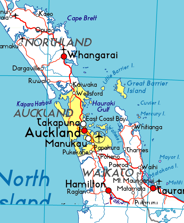
Well, it looks like Legaspi is and was the biggest place in the area (look here : http://en.wikipedia.org/wiki/Bicol_Region), and the Sorsogon looks like it grew up late as Sorsogon City was founded in 2000 from the joining of the towns of Sorsogon and Bacon.ORIGINAL: ptey
Another possibility would be to move the minor port one hex south-east and rename it Sorsogon?
Wikipedia doesnt seem to have much information of the history of the place, but today there apparently is something called Sorsogon City located in the bay at the west coast in the northen part of the hex south east of Legaspi. http://en.wikipedia.org/wiki/Sorsogon_City
The city is the combination of two former towns it says, with a total population of 151.000 (2007). Compared with 179.000 in Legaspi (2000).
Maybe the Legaspi port on the WIFFE maps is actually a depiction of the combination of these minor coastal towns at the southen tip of the peninsula? With Legaspi chosen as name because it was the biggest of the towns there. With the new scale, this might not be the best option anymore.
I think that Steve's solution is good, it will ook normal to have ships in Legaspi sail to the South China Sea and back. It already looks normal to me now.Regardless. Instead of moving Legaspi to an incorrect location, and giving it the ability of a 2 sea area port, even though it doesnt look like one on the map. I think its better to move the port one hex to the south-east and rename it to the biggest (coastal)town in the hex.
As I said previously there is no continent nor large mass of land preventing ships from Legaspi to reach the South China Sea, there is only a 50 km detour. I would have happily changed the port to the SE hex if there was a reason, and named it with a new name, and just left Legaspi in the previous place as a place name, but there is no justification for that, Legaspi is the real center of civilization in the Bicol Region of the Philippines.


