

I'm almost there, but I still have a few doubts.
The maps are all in 1:30 scale. 61.440x61.440km (2048x2048px). The bmps are all 24bit, 72px/in. The terrain file seems to be editable in-game and is the same size as the heightmap;
My main doubt is regarding the height range for the maps. The height file is just a raster image in BMP, and it seem to be a simple 2 colors, black to red gradient, but I noticed that one or other maps have a varying amount of green in their RGB range. I didnt find anything specified as vertical ranges, or vertical offset in any of table files, so I assume that the vertical range is within this 0-255 of red gradient. Sharp slopes seem to become automatically impassable terrain.
I already tried different sources, like Alos Palsar, SRTM 1arc & 3arc, aster and them exported as bmp, resized to 2048px in photoshop and imported ingame. I tried to set the color gradient as custom shaders in Global Mapper, in different vertical ranges, from say, 0 to 400m, 0 to 1000m, to the actual range of the terrain, or giving it offsets, but the resulting terrain is always extremely noisy, sometimes so noisy that its tiny slopes make the entire terrain impassable. I also tried to post process the height map in photoshop, reducing noise, giving some degrees of blur, it works, but it looses a lot of good resolution and the result is still unsatisfactory.
So, my questions are:
1- How should the bmp be processed and exported out of the GIS program?
2- How is the vertical range done?
Cheers
Map modding

RE: Map modding
PM me your email and I will email you the custom shader for use in GB. It uses the red and blue channels.
Flashpoint Campaigns Contributor
https://twitter.com/22sec2
https://twitter.com/22sec2
-
storm rider

- Posts: 40
- Joined: Wed Mar 13, 2013 6:19 pm
RE: Map modding
Thank you 22sec!
I'm trying to get in game a portion of southern iraq, about the general location of the 73 easting. The thing is that whatever source I have (Alos Palsar, Aster, SRTM 1 a 3Arc) are extremely bumpy, rough and noisy. I tried smoothing it using photoshop and l3dt, but if I go just a bit overboard, the map becomes minecraft like. I've never been there myself to be honest, but from the pictures and stories from that campaign, the terrain that I have in mind is completely different from the terrain that results from all my DEM sources. In my head, it should be flat as far as the eye can see, with only slight barely visible rolling terrain which are just enough in some parts to allow for some reverse slope like defense lines. Perhaps all of them suffer from some desert anomaly that makes them look rough and bumpy to every single imaging satellites or even, from what I know, this region doesn't have a fixed topography profile because it's subject to a shifting sand top cover, as is the case throughout the Arabian desert and during those years it was rough as hell. Anyway, I would like to know if you have any suggestion for post processing it best.
Cheers
I'm trying to get in game a portion of southern iraq, about the general location of the 73 easting. The thing is that whatever source I have (Alos Palsar, Aster, SRTM 1 a 3Arc) are extremely bumpy, rough and noisy. I tried smoothing it using photoshop and l3dt, but if I go just a bit overboard, the map becomes minecraft like. I've never been there myself to be honest, but from the pictures and stories from that campaign, the terrain that I have in mind is completely different from the terrain that results from all my DEM sources. In my head, it should be flat as far as the eye can see, with only slight barely visible rolling terrain which are just enough in some parts to allow for some reverse slope like defense lines. Perhaps all of them suffer from some desert anomaly that makes them look rough and bumpy to every single imaging satellites or even, from what I know, this region doesn't have a fixed topography profile because it's subject to a shifting sand top cover, as is the case throughout the Arabian desert and during those years it was rough as hell. Anyway, I would like to know if you have any suggestion for post processing it best.
Cheers
RE: Map modding
Height values are figured with the red and green channels. The blue channel is not currently used.
Red channels are 0-255 in meters. If a height value goes over 255, then add 1 to the green channel and then go back to red=0.
Formula is (Red Channel) + (Green Channel * 255).
For example: if a pixel value is RGB (171,1,0) then the height is (171) + (1 * 255) = 426
Another example: if a pixel value is RGB (107,2,0) then the height is (107) + (2 * 255) = 617
This was originally a design that worked with a program called Global Mapper (I think that is the name).
Red channels are 0-255 in meters. If a height value goes over 255, then add 1 to the green channel and then go back to red=0.
Formula is (Red Channel) + (Green Channel * 255).
For example: if a pixel value is RGB (171,1,0) then the height is (171) + (1 * 255) = 426
Another example: if a pixel value is RGB (107,2,0) then the height is (107) + (2 * 255) = 617
This was originally a design that worked with a program called Global Mapper (I think that is the name).
RE: Map modding
What scale did you export from GM?
Flashpoint Campaigns Contributor
https://twitter.com/22sec2
https://twitter.com/22sec2
-
storm rider
- Posts: 40
- Joined: Wed Mar 13, 2013 6:19 pm
RE: Map modding
horizontal scale 30m/px, resolution 72: 61.440km = 2048px and 122.880km = 4096px
I'm installing QGIS so I'm gonna try some of its filters to see if I can get better results. What I think I need is something like an adaptive smoothing for srtm.
I'm installing QGIS so I'm gonna try some of its filters to see if I can get better results. What I think I need is something like an adaptive smoothing for srtm.
RE: Map modding
Keep us posted and take a lot of notes [:D].
Kevin
Kevin
“The study of history lies at the foundation of all sound military conclusions and practice.”
Alfred Thayer Mahan
Alfred Thayer Mahan
RE: Map modding
I always make sure I am working from the same projection. I prefer to change my data to UTM in Global Mapper.

- Attachments
-
- Projection.jpg (150.82 KiB) Viewed 1168 times
Flashpoint Campaigns Contributor
https://twitter.com/22sec2
https://twitter.com/22sec2
RE: Map modding
Next I prefer to export as a PNG file which I can later convert to a 24-bit BMP file for use by the game engine.

- Attachments
-
- Export1.jpg (185.25 KiB) Viewed 1169 times
Flashpoint Campaigns Contributor
https://twitter.com/22sec2
https://twitter.com/22sec2
RE: Map modding
Last, and most important is to make sure the image is exported at 30m x 30m per pixel.

- Attachments
-
- Export2.jpg (170.53 KiB) Viewed 1168 times
Flashpoint Campaigns Contributor
https://twitter.com/22sec2
https://twitter.com/22sec2
RE: Map modding
I typically have used SRTM 3-second arc data. I think it works best at this scale, and there is world wide coverage.
Flashpoint Campaigns Contributor
https://twitter.com/22sec2
https://twitter.com/22sec2
-
CCIP-subsim

- Posts: 467
- Joined: Tue Nov 10, 2015 6:59 pm
RE: Map modding
So it turns out I'm completely useless with getting GlobalMapper to work 
Could I possibly solicit help from one of you with a height map for the Chechnya map I am currently working on?

Any chance you could export it out as an example? It doesn't have to be a precise fit, just something I could work with.
It would be immensely appreciated [:)]
Could I possibly solicit help from one of you with a height map for the Chechnya map I am currently working on?
Any chance you could export it out as an example? It doesn't have to be a precise fit, just something I could work with.
It would be immensely appreciated [:)]
RE: Map modding
Sure, send me the coordinates you want.
Flashpoint Campaigns Contributor
https://twitter.com/22sec2
https://twitter.com/22sec2
-
storm rider
- Posts: 40
- Joined: Wed Mar 13, 2013 6:19 pm
RE: Map modding
I wasted a whole day-off trying to get QGIS to work with r.denoise/pyproj. I'm feeling completely frustrated. What a piece of garbage!
RE: Map modding
ORIGINAL: storm rider
I wasted a whole day-off trying to get QGIS to work with r.denoise/pyproj. I'm feeling completely frustrated. What a piece of garbage!
Welcome to the wonderful world of map making. 🌍😬🍺
Flashpoint Campaigns Contributor
https://twitter.com/22sec2
https://twitter.com/22sec2
-
storm rider
- Posts: 40
- Joined: Wed Mar 13, 2013 6:19 pm
RE: Map modding
I made some good progress finally!
Does any know the exact location of the Battle of 73 Easting?
Most sources I have are a bit inaccurate and I'm a bit skeptical about them since I can't find any left over wrecks from this battle in google earth. There must still be dozens of destroyed tanks laying around there.
Does any know the exact location of the Battle of 73 Easting?
Most sources I have are a bit inaccurate and I'm a bit skeptical about them since I can't find any left over wrecks from this battle in google earth. There must still be dozens of destroyed tanks laying around there.
-
CCIP-subsim
- Posts: 467
- Joined: Tue Nov 10, 2015 6:59 pm
RE: Map modding
ORIGINAL: storm rider
I made some good progress finally!
Does any know the exact location of the Battle of 73 Easting?
Most sources I have are a bit inaccurate and I'm a bit skeptical about them since I can't find any left over wrecks from this battle in google earth. There must still be dozens of destroyed tanks laying around there.
The conventional location given is 29°32′41″N 46°37′33″E
Keep in mind that it's in the middle of a desert, and sands shift - so it would not be surprising to see no trace of the battle wreckage on any satellite photos.
I'd suggest a map layout roughly like this:

It starts a bit north of the Saudi border that way, but that also gives you all the main Coalition phase lines in one map and leaves a bit more room on the Iraqi side. Or you could push it a bit further south, or even try rotating the map a bit (you probably don't really need Kuwait in there, but that ridge running along the border is important).
-
CCIP-subsim
- Posts: 467
- Joined: Tue Nov 10, 2015 6:59 pm
RE: Map modding
(interestingly, Bing Maps has an aerial shot of the area - and there's at least a couple of things there that do look like wreckage, such as here: )
RE: Map modding
Perhaps this confirms the location. Or at least corroborates it.
https://latitude.to/articles-by-country ... 73-easting
Will keep looking a bit more.
Kevin
https://latitude.to/articles-by-country ... 73-easting
Will keep looking a bit more.
Kevin
“The study of history lies at the foundation of all sound military conclusions and practice.”
Alfred Thayer Mahan
Alfred Thayer Mahan
-
storm rider
- Posts: 40
- Joined: Wed Mar 13, 2013 6:19 pm
RE: Map modding
ORIGINAL: CCIP-subsim
ORIGINAL: storm rider
I made some good progress finally!
Does any know the exact location of the Battle of 73 Easting?
Most sources I have are a bit inaccurate and I'm a bit skeptical about them since I can't find any left over wrecks from this battle in google earth. There must still be dozens of destroyed tanks laying around there.
The conventional location given is 29°32′41″N 46°37′33″E
Keep in mind that it's in the middle of a desert, and sands shift - so it would not be surprising to see no trace of the battle wreckage on any satellite photos.
I'd suggest a map layout roughly like this:
It starts a bit north of the Saudi border that way, but that also gives you all the main Coalition phase lines in one map and leaves a bit more room on the Iraqi side. Or you could push it a bit further south, or even try rotating the map a bit (you probably don't really need Kuwait in there, but that ridge running along the border is important).
This is the location that I'm using. But I have the impression that it should be farther north. The other hint is that the Tawakalna division was deployed in a reverse slope, just after an imperceptible rolling hill.
The 61km square that I'm using is not actually centered on this location. I wanted to include as much of the terrain to the west so as to also include the forward scout elements of the RGFC, particularly on the 67 and 70 easting lines.
I made progress smoothing the srtms, but I'm still not quite happy.
Looking at the following picture, the terrain looks very smooth:
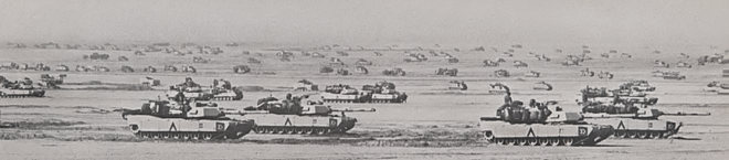
(70 easting)

General location

In-game view

Iso view

Minecraft terrain!