Designer's Notes: terrain interpretation

Graphics, sound, and database mods.

Scenarios should still be posted in the main 'Mods and Scenarios' forum below
Post Reply
User avatar
cathar1244
Posts: 1264
Joined: Sat Sep 05, 2009 2:16 am

Designer's Notes: terrain interpretation

Post by cathar1244 »

Image

Scenario design is multifaceted. Anyone who has put together a scenario for any wargame rapidly realizes a whole collection of skills is called for, ranging from collation of basic information to the interpretation of documents and maps.

It is the latter I'll mention in this thread. TOAW offers us a fair selection of terrain tiles to choose from when we make the map for a scenario. Informing us about which tiles to choose is the practice of terrain analysis, the data for which can be obtained from a good map.

Ah, "good map". What makes for a good map? I've found it is often necessary to consult more than one map for scenarios as the maps tend to be good at depicting topography or forestation, but usually not both. Let's look at the region between Stuttgart and Ulm ... an area dominated by the commanding heights and steep slopes of the Swabian Alb.

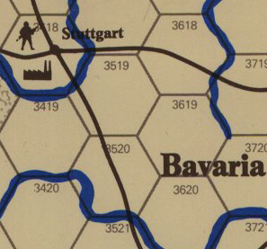
First off, here is how the area was depicted in SPI's War in Europe.

Image

Next up is a depiction from SPI's The Next War.

Image

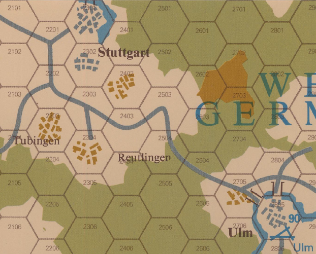
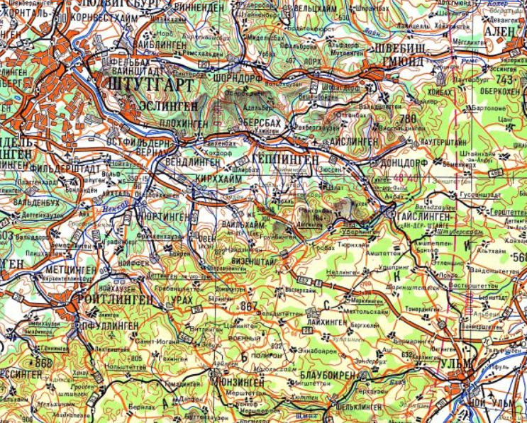
Quite a difference in the two depictions. The TNW map indicates (correctly) there is rough terrain in that area. For me, the real lesson here is that maps in existing wargames should be taken with a grain of salt. The next image shows this area as it was depicted on a Gea map in prewar Germany (the Gea maps were subsequently used in the production of Lage Ost etc. maps by the German military during the war.)

Image

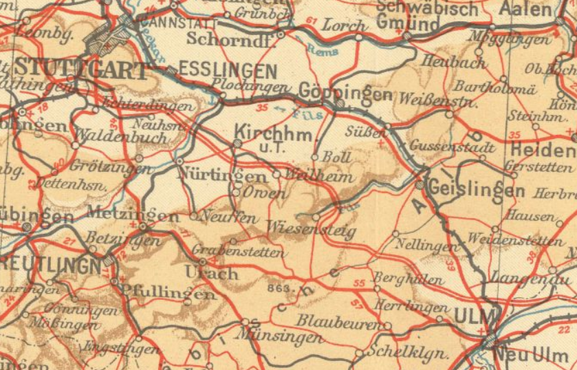
Take a look at the thick brown line vicinity of Wiesensteig. That is a feature that could be well modeled by the use of "escarpment" tiles in TOAW. As well, the region is marked by high hills and small mountains that rise up steeply on the western side. (The Gea maps are very useful in this regard; they show elevation changes well. This IMO is more indicative of where tiles such as hills and mountains should be placed rather than pure elevation maps that don't indicate the location of high plateaus and other flat areas.)

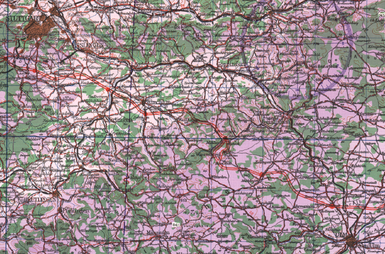
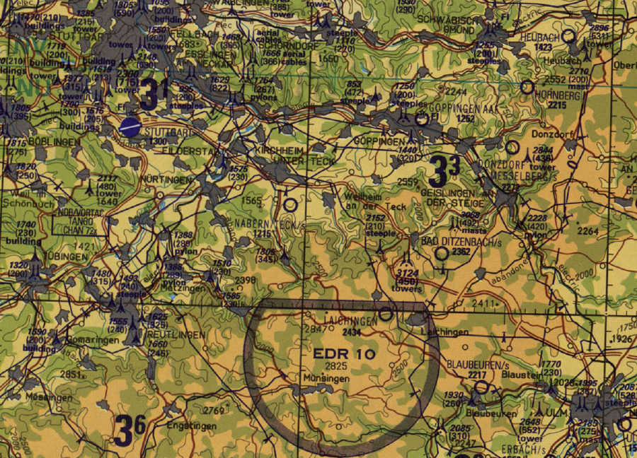
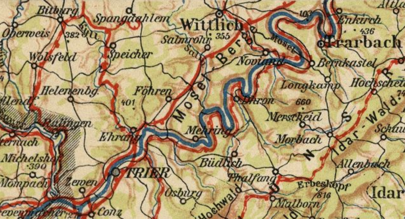
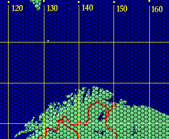
Still didn't help with forestation, though. This (U.S.) Army Map Service map gives a good idea of where forests are:

Image

One style that blends both kinds of information is this Tactical Pilotage Chart:

Image

A lot of information to be had from the "real" maps; a necessary skill for the scenario designer at this point is to boil down what is essential for the scenario under design. I did mention a collection of skills as required for scenario design, didn't I? [;)] Every designer will have their own preferences as to what works best for them.

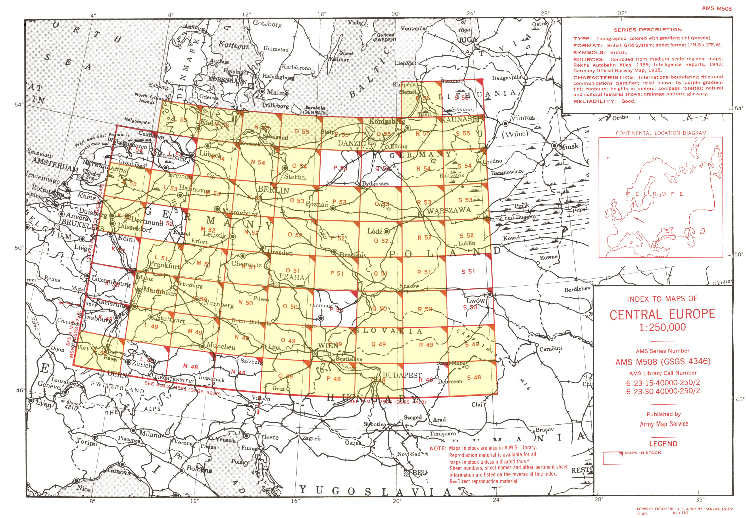
Okay. For those interested in where these kind of maps can be found online.

Army Map Service 1/250,000 topographic maps. http://legacy.lib.utexas.edu/maps/ams/c ... ex_map.jpg

Tactical Pilotage Charts at 1/500,000. http://legacy.lib.utexas.edu/maps/tpc/e ... index.html

The Gea map mentioned here. https://www.landkartenarchiv.de/vollbil ... _Suedblatt

Cheers
User avatar
Bamilus
Posts: 979
Joined: Fri Apr 30, 2010 3:01 pm
Location: The Old Northwest

RE: Designer's Notes: terrain interpretation

Post by Bamilus »

Your posts are always super fascinating. Keep up the good work.
Paradox Interactive Forum Refugee
User avatar
Curtis Lemay
Posts: 14844
Joined: Fri Sep 17, 2004 3:12 pm
Location: Houston, TX

RE: Designer's Notes: terrain interpretation

Post by Curtis Lemay »

I used Tactical Pilotage Charts for CFNA and France 1944.
My TOAW web site:

Bob Cross's TOAW Site
User avatar
cathar1244
Posts: 1264
Joined: Sat Sep 05, 2009 2:16 am

RE: Designer's Notes: terrain interpretation

Post by cathar1244 »

Cheers, Bamilus!
User avatar
cathar1244
Posts: 1264
Joined: Sat Sep 05, 2009 2:16 am

RE: Designer's Notes: terrain interpretation

Post by cathar1244 »

ORIGINAL: Curtis Lemay

I used Tactical Pilotage Charts for CFNA and France 1944.

The TPC's are a nice compromise of forestation and topographical data. Makes it a lot easier to put down terrain tiles if one can get a hex grid overlaid on a map like the TPC and have everything on one source map.

Cheers
User avatar
mussey
Posts: 682
Joined: Sat Dec 02, 2006 1:21 pm
Location: Cleve-Land

RE: Designer's Notes: terrain interpretation

Post by mussey »

modeled by the use of "escarpment" tiles

It is here that I find the most difficult, because unlike easy-to-see terrain like a town, river, or forest, escarpments are not consistently easy to find on maps. What I enjoy about this process is that map design is as much artistic creativity as it is a calculated process. (Which is why I can't stop fiddling with my scenario map, kind of like the Joy of Painting sensation, a Bob Ross moment[:)]).

Thanks Cathar, I guess I'll have to stock up on some more Cabernet, break out my magnifying glass, and make a go on these links.
Col. Mussbu

The long arm of the law - "The King of Battle"

User avatar
cathar1244
Posts: 1264
Joined: Sat Sep 05, 2009 2:16 am

RE: Designer's Notes: terrain interpretation

Post by cathar1244 »

Mussey, for your scenario (and escarpment data) you may find this series interesting:

https://www.landkartenarchiv.de/deutsch ... rasien.php

1/800,000, between the World Wars, and has some of that thick brown shading indicating abrupt elevation change. For example, this map,

https://www.landkartenarchiv.de/uebersi ... _Metz_1932

-- look at the top of the map showing the Mosel Valley near Trier etc. That thick brown shading, and boy, is that river ever a huge trench cut into the high hills / low mountains there. Also possible to get forestation data off that series, although it strains my eyes to see where the forests begin and end.

Image

Cheers
User avatar
Lobster
Posts: 5489
Joined: Thu Aug 08, 2013 2:12 pm
Location: Third rock from the Sun.

RE: Designer's Notes: terrain interpretation

Post by Lobster »

ORIGINAL: mussey
map design is as much artistic creativity as it is a calculated process

This ^^

That is why it's unimportant to tell someone their map is wrong.

Personally I try and use a map that covers the scenarios time period. A forest can be cut, grown, cut and grown again in 74 years. Can't say what was growing there now is what was growing there 74 or more years ago. Rivers are dammed and/or change course. Cities grow or shrink or vanish all together. Names are changed. Swamps are drained. Land is flooded. Levies are abandoned or built. Transportation routes come and go. Much changes over many decades.

For years I've used the U of Texas site and Mapstor who now sells many WW2 and earlier topo maps.

There used to be a section with all sorts of these links. Not sure if it's still around.
ne nothi tere te deorsum (don't let the bastards grind you down)

If duct tape doesn't fix it then you are not using enough duct tape.

Two things are infinite: the universe and human stupidity and I’m not sure about the universe-Einstein.
User avatar
cathar1244
Posts: 1264
Joined: Sat Sep 05, 2009 2:16 am

RE: Designer's Notes: terrain interpretation

Post by cathar1244 »

This is a nice set for terrain, less so for place names unless one reads Cyrillic. I like the way the rapid increase in elevation is depicted, and the forestation is readily apparent. From Soviet 1/500,000 maps. Not sure about the different colors of green; unfortunately, the legend is not on these scans.

Image

Series at https://www.landkartenarchiv.de/weltkar ... mir500.php

Cheers
User avatar
cathar1244
Posts: 1264
Joined: Sat Sep 05, 2009 2:16 am

RE: Designer's Notes: terrain interpretation

Post by cathar1244 »

Terrain interpretation: Does it fit?

There are at least two aspects to 'fit' in terms of placing terrain tiles in TOAW. These questions of fit are designer judgment calls.

The first question concerns the scale of units and their relationship to the time and hex scale of the scenario under design. A good example of this is depiction of rivers. The question of whether to include a particular river or not should hinge upon scale. A swift stream that would stop a battalion for a day is not a water obstacle one should depict if the scenario in question uses corps-sized units, hexes that are tens of kilometers from side to side, and turns representing a duration of a week or more. A guideline in this case is to consider if the terrain in a given hex imposes unrealistic effects in terms of the scenario time and space scales.

The other question concerns the terrain tiles themselves. This may be a matter of personal taste, but some of the tiles are more applicable to tactical scenarios than to operational-scale scenarios. In particular, rocky and cropland are well suited for hex scales that are not too large. However, the use of these tiles may be indicated if the designer seeks a particular defensive or mobility effect in a given hex.

Scenarios using hex scales of tens of kilometers may be candidates for simpler terrain depiction -- eschewing the use of light woods, for example. While it is tempting to try to represent a map's terrain very exactly, it can lead to visual clutter on the map and impose ahistorical obstacles on the units.

Cheers
User avatar
cathar1244
Posts: 1264
Joined: Sat Sep 05, 2009 2:16 am

RE: Designer's Notes: terrain interpretation

Post by cathar1244 »

Terrain interpretation: Is this a 'super' river?

I find rivers, at times, difficult to size up. Maps can give an indication of the river's breadth, but other key aspects of rivers are not so easily discovered on the internet, such as rate of flow at given points and steepness of the banks.

In general, the question of 'fit' for a scenario is indicated by history. Rivers that were a problem for a military force will be mentioned, and the scenario designer can use these hints from history to determine which rivers should be depicted in a scenario. As a matter of personal preference, I like a map to have fewer rivers because of TOAW's placement of rivers within the hex, particularly considering the effects of 'super' rivers.

'Super' rivers should only appear in a scenario when a particular stream served to anchor a strong defensive line or constituted a water obstacle that required the deployment of significant engineer assets to cross. Once again, if in doubt, a less cluttered map is usually preferable.

Cheers
User avatar
cathar1244
Posts: 1264
Joined: Sat Sep 05, 2009 2:16 am

RE: Designer's Notes: terrain interpretation

Post by cathar1244 »

As an aside, I'm working on a TOAW map and used the ODD software made by Raindem, a member of our forum. His ODD program makes it very easy to lay down a hexagonal grid -- thanks Raindem!

Cheers
User avatar
larryfulkerson
Posts: 42784
Joined: Sat Apr 16, 2005 9:06 pm
Location: Tucson, AZ,usa,sol, milkyway
Contact:

RE: Designer's Notes: terrain interpretation

Post by larryfulkerson »

As brought out magnificantly above, I'm concerned that some terrain might not "fit" the scenario being played on it. I'm thinking of those smaller scenarios that cover maybe 100 sq miles and feature platoons and maybe companies and last for less than 20 turns of 1/2 day turns and is in the range of direct fire only. The terrain probably shouldn't have mountain ranges and multiple super rivers, and networks of roads and rails. It should be more like the terrain panels that Advanced Squad Leader used to have. They fit together reguardless of how you arranged them and you could build whatever kind of terrain the situation called for. I'm thinking that the longer scenarios, the bigger scenarios, the more complex scenarios will probably need to look more like the terrain we're already using. See the problem? The terrain needs to "fit" the scenario being played on it.
The Seabees On Iwo Jima | Full Documentary
https://www.youtube.com/watch?v=qh1IAZfJK6c
User avatar
cathar1244
Posts: 1264
Joined: Sat Sep 05, 2009 2:16 am

RE: Designer's Notes: terrain interpretation

Post by cathar1244 »

Larry, I've at times wished for a "designer tile" -- a tile that we could give a name to and specify the movement and combat effects it imposes. I know we can put more than one kind of tile in a hex, but one sees the lengths designers go to in order to achieve a particular effect. Seeing "badlands" tiles in northern Russia makes me wince, although I understand why a designer might choose to do so.

Cheers
User avatar
Lobster
Posts: 5489
Joined: Thu Aug 08, 2013 2:12 pm
Location: Third rock from the Sun.

RE: Designer's Notes: terrain interpretation

Post by Lobster »

Sometimes it's not possible. Looking at the Shchara River that runs through Slonim (Slonim is between Brest and Minsk) you wouldn't think it was much of an obstacle. Yet when Pavlov attempted to disengage from Guderian's Second Panzer Group and take up positions on the east side of the Shchara River around Slonim on 25-26 June the 10th Army couldn't. German aircraft had destroyed most of the bridges. So if the 10th Army was pinned against the Shchara River it should be a major river right?

If you look on the RKKA maps of the era the Shchara River around Slonim is 50 to 60 meters wide and about 1.5 meters deep, a little deeper in spots. While Pavlov's Front was in almost total disarray you would think that was not so much of an obstacle as to keep an army from crossing. Yet there it is.

When Guderian and Hoth were approaching Orsha/Mogilev Hoth's Panzer Group " discovered a hard-surfaced road between Borisov and Lepel' not on his maps, every one of it's more than 100 wooden bridges along a 80-kilometer stretch had collapsed because of the heavy traffic, thereby preventing lateral movement by his two corps." (Barbarossa Derailed: The Battle For Smolensk by David Glantz)

There are some things that happened historically that you cannot fit no matter how you try. There are some that you can. For instance, when Guderian reached the Dnepr River it was flooding. The width was almost 800 meters preventing any units from crossing. How does one model a flooded major river, a temporary state yet one that causes major problems? You can't, not if the scenario is going to go beyond the river's flooded state. You are forced to make the river it's normal state. If we had more exclusion zones it would be possible but there are only two.
ne nothi tere te deorsum (don't let the bastards grind you down)

If duct tape doesn't fix it then you are not using enough duct tape.

Two things are infinite: the universe and human stupidity and I’m not sure about the universe-Einstein.
User avatar
cathar1244
Posts: 1264
Joined: Sat Sep 05, 2009 2:16 am

RE: Designer's Notes: terrain interpretation

Post by cathar1244 »

This comment is a brief detour on a side road. A map is under construction. The first image shows the image providing the layout the TOAW map will have:

Image

I put a grid on the image so that I could somewhat track the hex columns and rows because this is a map with over 200 rows and columns.

Next image shows the TOAW map under construction (first phase: land masses and deep water). The odd "columns" of water are in the hex columns that match the gridlines on the other image. The columns proceed south until the next hex will be dry land. Thus will the coastline be eventually plotted.

Image

Cheers
Post Reply

Return to “Mods”