

Did so but he has not been around in a few weeks it seems so thought I would ask others. I think I am going to put off my game until this next beta release and use the new extended map if the AI can handle it now anyway...
An update to the official game map
Moderators: wdolson, MOD_War-in-the-Pacific-Admirals-Edition
Re: An update to the official game map

Check out my mod for Strategic Command American Civil War!
https://forums.matrixgames.com/viewtopic.php?t=413785
Re: An update to the official game map
In the new beta Kyushu is still disconnected by road and rail to the rest of Japan? See previous discussions...
Check out my mod for Strategic Command American Civil War!
https://forums.matrixgames.com/viewtopic.php?t=413785

Re: An update to the official game map
Resources, oil, fuel, supplies, and such like will flow but units can't move across. Apparently the rail and road connections occurred later.Tanaka wrote: Fri Nov 08, 2024 9:46 pm In the new beta Kyushu is still disconnected by road and rail to the rest of Japan? See previous discussions...
Seek peace but keep your gun handy.
I'm not a complete idiot, some parts are missing!
“Illegitemus non carborundum est (“Don’t let the bastards grind you down”).”
 ; Julia Child

I'm not a complete idiot, some parts are missing!
“Illegitemus non carborundum est (“Don’t let the bastards grind you down”).”
Re: An update to the official game map
Ah good to know this was an intentional change thanks! Don't see this in the patch notes though?RangerJoe wrote: Fri Nov 08, 2024 11:55 pmResources, oil, fuel, supplies, and such like will flow but units can't move across. Apparently the rail and road connections occurred later.Tanaka wrote: Fri Nov 08, 2024 9:46 pm In the new beta Kyushu is still disconnected by road and rail to the rest of Japan? See previous discussions...
Check out my mod for Strategic Command American Civil War!
https://forums.matrixgames.com/viewtopic.php?t=413785
Re: An update to the official game map
what is the border between hexes? sea or land?Tanaka wrote: Fri Nov 08, 2024 9:46 pm In the new beta Kyushu is still disconnected by road and rail to the rest of Japan? See previous discussions...
if sea, then nothing will flow, if land then everything will flow, but the units would take more time to move
Also, the connections could be abstracted as ferries. I don't really see why this is changed after so many years, when no one was even arguing about it.

Re: An update to the official game map
Another question:
Are Andrew Brown stacking limits files from here: https://sites.google.com/view/witp-ae-m ... ficial-map
compatible with the published November 2024 beta and its map changes? The dat files have different dates (Andy Brown's are 2009, beta's are 2024), but they may include the identical map changes.
Are Andrew Brown stacking limits files from here: https://sites.google.com/view/witp-ae-m ... ficial-map
compatible with the published November 2024 beta and its map changes? The dat files have different dates (Andy Brown's are 2009, beta's are 2024), but they may include the identical map changes.
Last edited by Yaab on Mon Nov 11, 2024 9:27 am, edited 1 time in total.
Re: An update to the official game map
Good question. His website does say 2024 now though...Yaab wrote: Sat Nov 09, 2024 8:32 am Another question:
Are Andrew Brown stacking limits files from here: https://sites.google.com/view/witp-ae-m ... ficial-map
compatible with the published November 2024 beta and its map changes? The dat files have different dates (Andy Brown's are 2009-2011, beta's are 2024), but they may include the identical map changes.
Check out my mod for Strategic Command American Civil War!
https://forums.matrixgames.com/viewtopic.php?t=413785
Re: An update to the official game map
When you try to download the Andrew Brown SL files, you get this prompt with the file names and their time-stamps.
Andy Brown's pwzlink and pwzone files are from 2009, while beta's are from 11 August 2024.
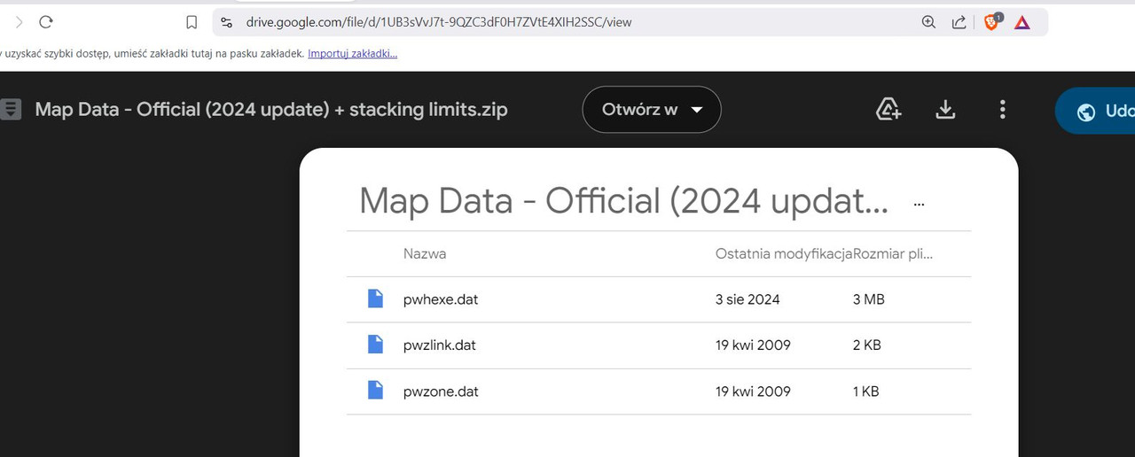
Andy Brown's pwzlink and pwzone files are from 2009, while beta's are from 11 August 2024.
Re: An update to the official game map
v1128b, scen001
Starting from this post
https://www.matrixgames.com/forums/view ... 3#p5200443
I documented a total of 37 hexes, where there is a discrepancy between displayed map terrain and data terrain.
Starting from this post
https://www.matrixgames.com/forums/view ... 3#p5200443
I documented a total of 37 hexes, where there is a discrepancy between displayed map terrain and data terrain.

-
bradfordkay
- Posts: 8686
- Joined: Sun Mar 24, 2002 8:39 am
- Location: Olympia, WA
Re: An update to the official game map
I have not downloaded 1128 as of yet (want to finish my babes campaign first) so this is from the old map.
I was messing around on google maps as I often do - I especially like to look for WW2 airfields on the various islands - and was surprised to find that the port of Saumlaki is on the SE side of its island, whereas the map data does not allow ship movement in that direction. Instead it allows ship movement to the north and west. Sailing west out of Saumlaki is certainly possible, but sailing north is not possible. I zoomed in on the satellite photos to see if there are any reefs preventing ships from sailing to the south and east and see none. I do see that there is a ferry route to what the Dutch called Kai-Eilanden that south then east around the peninsula on which Saumlaki sits before turning north to the present day city of Tual (from which you can catch another ferry to Dobo or Babo).
It's a minor detail that probably doesn't make a difference in game terms, but it does bug the old navigator in me...
fair winds,
Brad
Brad
Re: An update to the official game map
The satellite image might have been high tide (you would have to compare the map timestamp against tide charts). However, I think this is an oops and Dave would likely fix based upon your research above when he sees this.bradfordkay wrote: Thu Dec 19, 2024 7:12 am I have not downloaded 1128 as of yet (want to finish my babes campaign first) so this is from the old map.
I was messing around on google maps as I often do - I especially like to look for WW2 airfields on the various islands - and was surprised to find that the port of Saumlaki is on the SE side of its island, whereas the map data does not allow ship movement in that direction. Instead it allows ship movement to the north and west. Sailing west out of Saumlaki is certainly possible, but sailing north is not possible. I zoomed in on the satellite photos to see if there are any reefs preventing ships from sailing to the south and east and see none. I do see that there is a ferry route to what the Dutch called Kai-Eilanden that south then east around the peninsula on which Saumlaki sits before turning north to the present day city of Tual (from which you can catch another ferry to Dobo or Babo).
It's a minor detail that probably doesn't make a difference in game terms, but it does bug the old navigator in me...
In any case, THANK YOU as I plan to update my pwhexe files appropriately.
Pax

Re: An update to the official game map
Not sure if this is still relevant
2 hexes should be os but have od map art (2024 update stock and stacking limits)
2 hexes should be os but have od map art (2024 update stock and stacking limits)
- Skærmbillede (7).png (325.63 KiB) Viewed 1422 times
Z
-
Shellshock

- Posts: 574
- Joined: Fri Dec 31, 2010 2:23 pm
- Location: U.S.
Re: An update to the official game map
I noticed this as well some time ago. But considering how remote that area is from where most subs or ships operate I can see where it wouldn't be a big priority to fix.zebrazwo wrote: Sat Aug 16, 2025 9:23 pm 2 hexes should be os but have od map art (2024 update stock and stacking limits)
-
LargeSlowTarget

- Posts: 5051
- Joined: Sat Sep 23, 2000 8:00 am
- Location: Hessen, Germany - now living in France
Re: An update to the official game map
I think the hexsides allowing ship movements to the NE and NW from the port of Saumlaki are a compromise forced by the map distortion, the maintaining of more or less correct distances between bases and the rigid hex grid. The hex grid placed over the map puts the main body of Jamenda - the island Saumlaki is located on - in the hex 78/117. However, the extreme SE point of that island, where Saumlaki is actually located, overlaps into the hex 78/118, where the dot base of Selaroe is located. Since it not possible to have two bases in the same hex, Saumlaki has been placed in the hex 78/117 i.e. on the main body of Jamenda island and not on the SE tip at 78/118 where it 'should' be. Consequently, the base flag in 78/117 makes it look like Saumlaki being on the NW coast of the island. Now, it would raise even more eyebrows of players unfamiliar with the area if a port seemingly located on the north coast would not allow ship movement to the NW and NE hex sides. Therefore, as a compromise, those hexsides allow ship movement out of Saumlauki - although this port in reality is landlocked on the northern sides. In order to make things foolproof, both hexsides and the map art would require changes. IMO the island group should be shifted a few mills to the SE to allow Saumlaki to be placed in the hex 79/118. Like this :PaxMondo wrote: Thu Dec 19, 2024 8:22 pmThe satellite image might have been high tide (you would have to compare the map timestamp against tide charts). However, I think this is an oops and Dave would likely fix based upon your research above when he sees this.bradfordkay wrote: Thu Dec 19, 2024 7:12 am I have not downloaded 1128 as of yet (want to finish my babes campaign first) so this is from the old map.
I was messing around on google maps as I often do - I especially like to look for WW2 airfields on the various islands - and was surprised to find that the port of Saumlaki is on the SE side of its island, whereas the map data does not allow ship movement in that direction. Instead it allows ship movement to the north and west. Sailing west out of Saumlaki is certainly possible, but sailing north is not possible. I zoomed in on the satellite photos to see if there are any reefs preventing ships from sailing to the south and east and see none. I do see that there is a ferry route to what the Dutch called Kai-Eilanden that south then east around the peninsula on which Saumlaki sits before turning north to the present day city of Tual (from which you can catch another ferry to Dobo or Babo).
It's a minor detail that probably doesn't make a difference in game terms, but it does bug the old navigator in me...
In any case, THANK YOU as I plan to update my pwhexe files appropriately.
- saumlaki.jpg (39.96 KiB) Viewed 1360 times

-
bradfordkay
- Posts: 8686
- Joined: Sun Mar 24, 2002 8:39 am
- Location: Olympia, WA
Re: An update to the official game map
LST... that would be an excellent correction.
fair winds,
Brad
Brad

Re: An update to the official game map
Very nice touch.

Member: Treaty, Reluctant Admiral and Between the Storms Mod Team.
Re: An update to the official game map
It would seem that Andrew is still making changes/corrections to the map :
look at the date !
link is of course https://sites.google.com/view/witp-ae-m ... andard-map
LOVE IT ANDREW!
look at the date !
- Pic for Andrews's site
- Skærmbillede 2026-01-08 211435.png (45.19 KiB) Viewed 663 times
link is of course https://sites.google.com/view/witp-ae-m ... andard-map
LOVE IT ANDREW!
Z