
Hi all,
Andrew and I have discussed this issue and we would like to have the rest of the CHS comment on it.
I have redone the range for virtually every aircraft in the game and found a few interesting things out.
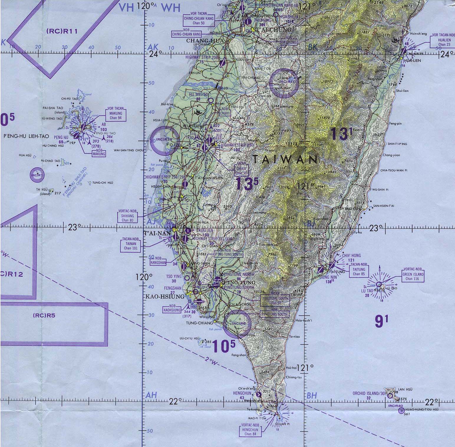
One problem i have found is that Takao is in the wrong hex, it should be moved up one hex to join Tainan. Probably should keep the name Takao as it was a more important city.
The little peninsula of land in the south should have no base; I have been to Taiwan and there is very little there now.
This change will make aircraft ranges work better; as it stands flying from Takao Zeroes can reach Manila and Ki-27's can reach Clark Field. Both of those are unrealistic.
So, the question is do we combine bases? Is this a good idea?
Does anyone have more extensive data on Taiwan bases during the war?
Thanks,
Michael
Map question
Moderators: wdolson, Don Bowen, mogami

RE: Map question
I'd vote for the combination (and calling it Takao). Minor change to text on map but well worth it for historical accuracy.
Question: would the base values be those of Takao or some higher value to represent both Takao and Tainan??
RE: Map question
I would probably make it a 5(6) port and a 6(6) airfield. Maybe a 7(6) airfield. I will check how many planes would be based in the combined base.
Mike
Mike

RE: Map question
Okay, it would have to be a 7 airfield; i show 311 aircraft based in that hex. I just found 2 more air units not included in the game... never ending struggle to fix the OOB.
It is getting closer to what my other sources say however, there should be aroud 4000 combat aircraft available on Dec 8th.
Mike
It is getting closer to what my other sources say however, there should be aroud 4000 combat aircraft available on Dec 8th.
Mike
-
treespider

- Posts: 5781
- Joined: Sun Jan 30, 2005 7:34 am
- Location: Edgewater, MD
RE: Map question
http://www.lib.utexas.edu/maps/middle_e ... onc_84.jpg
http://www.lib.utexas.edu/maps/middle_e ... n_1958.jpg
http://www.lib.utexas.edu/maps/middle_e ... n_1958.jpg
Here's a link to:
Treespider's Grand Campaign of DBB
"It is not the critic who counts, .... The credit belongs to the man who is actually in the arena..." T. Roosevelt, Paris, 1910
Treespider's Grand Campaign of DBB
"It is not the critic who counts, .... The credit belongs to the man who is actually in the arena..." T. Roosevelt, Paris, 1910
-
jwilkerson

- Posts: 8272
- Joined: Sun Sep 15, 2002 4:02 am
- Location: Kansas
- Contact:
RE: Map question
ORIGINAL: Lemurs!
I would probably make it a 5(6) port and a 6(6) airfield. Maybe a 7(6) airfield. I will check how many planes would be based in the combined base.
Mike
I have a map from the game "War of Resistance" which is supposed to be accurate from 1937-1941 ... it shows Tainan and Takao 2 hexes apart or 32 miles ... and it shows the peninsula as extending 4 hexes "south" from Takao and containing nothing but rough, and rough jungle terrain ... the GDW/GRD products may not be the greatest games but I buy them for the research .. they are top noch as far as OB research and the maps ...
The proposed combination would move the initial "Zero" base back one square but still leave Manilla within normal range.
I support the combination ... though 7(6) sounds like a huge place and can grow to a 9(6) ... ( I look more at the maximum size for most places than the starting size ) but it needs to be big enough to support the historical operations on 8 Dec ...
As to basing for opening attack ... I can put my hands quickly on what was in the Formosa, by squadron for both IJA and IJN ... but not by base ... though I would assume everything was at this one combined base ... since the numbers that might have been elsewhere would be small enough to not matter ...
WITP Admiral's Edition - Project Lead
War In Spain - Project Lead
War In Spain - Project Lead
-
Bradley7735

- Posts: 2073
- Joined: Mon Jul 12, 2004 8:51 pm
RE: Map question
I definitely think the SPS should be at least 6. I'm not sure how many other bases are on Formosa, but when Halsey attacked in mid 44, there were hundreds of planes there. Any 60 mile hex that is composed of mostly land should be SPS 6 or higher. There were probably dozens of airfields in that hex in WWII. (same with Luzon and other large land masses in PI)
my 2 cents
my 2 cents
The older I get, the better I was.
-
jwilkerson
- Posts: 8272
- Joined: Sun Sep 15, 2002 4:02 am
- Location: Kansas
- Contact:
RE: Map question
As long as you think "B29s will fly from here" makes sense ... then I'll agree !
WITP Admiral's Edition - Project Lead
War In Spain - Project Lead
War In Spain - Project Lead
RE: Map question
Treespider, thanks for maps man! Those are awesome. Permanant part of my collection now.
Joe, GRD games are awesome, where do you think i got a lot of my research? War of Ressistance & Damned Die Hard!
I have all of the squadron details already, thanks, what i had needed were better maps. These maps confirmed my suspicion.
I think i am with Bradley on this one, and clear hex on a large land mass should at least a SPS 6-9.
All of the Army bases were in the same hex. That makes a total in that hex of 541 planes or there abouts.... what is that, a 10?
On the peninsula hex, as we see in those excellent maps, all that is there are rocks. One village at the southern tip with a Pop in 1949 of 5000. No known air base. The next hex up on our map is our Tainan.
I have been to Taiwan and i am firmly of the belief that that hex should be clear, probably the clearest location on the island.
I guess to be accurate we should make it a 9(9) and i move a few aircraft to other hexes to get it down to 450 planes. Or a bit less.
What are our thoughts on this?
I think we may want to look at many land bases that have low SPS numbers.... I realize rougher terrain, etc, limits many places but i swear there are a few spots in China where a SPS 6 or higher would be accurate.
I do not advocate this for less than 1 hex islands or anything crazy like that but a complete land hex has enough room for many airfields.
And Joe, just imagine WITP on GRD maps for the entire area. GRD scale as well. And break down counters (that work) for all units.
sigh.
Mike
RE: Map question
The main reason i noticed a problem is that the Ki27B was the main army fighter with a range of 1700km... while the Zero had a range of 1890km. Real close. In the Matrix version they seem to have the Ki27a modeled which was no longer in use.
With my new model Ki27's could fly to clark and Zeroes could fly to Manilla. Just not right.
Mike
With my new model Ki27's could fly to clark and Zeroes could fly to Manilla. Just not right.
Mike
-
Bradley7735
- Posts: 2073
- Joined: Mon Jul 12, 2004 8:51 pm
RE: Map question
Lemurs, I agree with your thought regarding increasing the SPS of some large, clear land masses. Kona is one that should be increased. I'm not sure about too many other places. Probably most of the bases in China and India. I guess if it's clear or forest and the hex is mostly land, then it should be SPS of 6 or more. Jungle would probably inhibit the construction enough that bases in Burma, DEI, etc probably are ok as is.
It's probably not a huge issue. Does it really matter if Kona is larger or not? There's still enough room in all the bases of Hawaii that you don't need a size 9 airfield at Kona. Same thing in China. It might be more accurate that some bases be increased, but it won't be a game breaker if they aren't. (Malaria bases will matter if you increase them, since the larger the base, the less effect of malaria)
It's probably not a huge issue. Does it really matter if Kona is larger or not? There's still enough room in all the bases of Hawaii that you don't need a size 9 airfield at Kona. Same thing in China. It might be more accurate that some bases be increased, but it won't be a game breaker if they aren't. (Malaria bases will matter if you increase them, since the larger the base, the less effect of malaria)
The older I get, the better I was.
RE: Map question
Not to sidetrack this topic but a question/request on Andrew's map, how about a path from the Middle East/Aden with an exit somewhere near to Broome or Perth along the west side of the map to represent shipments that took a straighter more southernly course across the Indian Ocean?
-
Andrew Brown

- Posts: 4087
- Joined: Tue Sep 05, 2000 8:00 am
- Location: Hex 82,170
- Contact:
RE: Map question
ORIGINAL: jcjordan
Not to sidetrack this topic but a question/request on Andrew's map, how about a path from the Middle East/Aden with an exit somewhere near to Broome or Perth along the west side of the map to represent shipments that took a straighter more southernly course across the Indian Ocean?
I thought about adding such a path, but I decided against it as there is not enough space on the left edge of the map. The path would be too easy for the Japanese player to interdict with aircraft operating from Carriers in the Indian Ocean, and, possibly, land based air out of Colombo or even Addu Atoll.
Andrew

-
Bradley7735
- Posts: 2073
- Joined: Mon Jul 12, 2004 8:51 pm
RE: Map question
FYI, in the CHS scenario, Perth receives daily supply and oil to simulate convoys that come from off map areas. So, it's kind of accurate to use on map convoys to deliver additional supply to western australia. (although it would be nice to be able to run convoys much further south to avoid most possible interdiction efforts)
The older I get, the better I was.
RE: Map question
Ok thanks, didn't notice that Perth got some extra oil/resources, guess have to take a closer look next time.
Andrew almost to the point where I can see if there is some kind of pathing error with northern OZ, still can't get troops to march directly to Darwin unless they're the hex just south of it. I'm currently marching the small companies that start in Darwin to Wyndom(sp?) & Derby & they're almost to the river which is what I'm trying to see if that is what may be causing the error I sent you a month or so ago where troop miles build up but they never move to destination. The only other thing is to do like I'm doing when I march troops to Darwin or bring them in by sea.
Andrew almost to the point where I can see if there is some kind of pathing error with northern OZ, still can't get troops to march directly to Darwin unless they're the hex just south of it. I'm currently marching the small companies that start in Darwin to Wyndom(sp?) & Derby & they're almost to the river which is what I'm trying to see if that is what may be causing the error I sent you a month or so ago where troop miles build up but they never move to destination. The only other thing is to do like I'm doing when I march troops to Darwin or bring them in by sea.
-
Andrew Brown
- Posts: 4087
- Joined: Tue Sep 05, 2000 8:00 am
- Location: Hex 82,170
- Contact:
RE: Map question
ORIGINAL: jcjordan
Ok thanks, didn't notice that Perth got some extra oil/resources, guess have to take a closer look next time.
Andrew almost to the point where I can see if there is some kind of pathing error with northern OZ, still can't get troops to march directly to Darwin unless they're the hex just south of it. I'm currently marching the small companies that start in Darwin to Wyndom(sp?) & Derby & they're almost to the river which is what I'm trying to see if that is what may be causing the error I sent you a month or so ago where troop miles build up but they never move to destination. The only other thing is to do like I'm doing when I march troops to Darwin or bring them in by sea.
Hi,
Sorry - I think I let this slip due to real life being very busy for me lately. Is it possible for you to send the save again, and I will take a look?
Andrew
RE: Map question
No problem, just trying some more experimentation to see what may be wrong with targetting Northern OZ.