The quality of the map/screenshots

Take command of air and naval assets from post-WW2 to the near future in tactical and operational scale, complete with historical and hypothetical scenarios and an integrated scenario editor.

Moderator: MOD_Command

Maesphil74
Posts: 93
Joined: Fri Apr 10, 2009 5:51 pm

RE: The quality of the map/screenshots

Post by Maesphil74 »

ORIGINAL: Sunburn
ORIGINAL: Fleming
Your trailer you did in Youtube?
You really need the link? [X(]
tm.asp?m=3417579
(you did know there was a trailer for this game, right [;)])

I did, but I wanted to make sure we were talking about the same video.

No extras on that one either, all stock map layers.

yes, that's what I allready learned from Phoenix.
All taken zoomed out to avoid the bluriness.

thanks
Phil
Dimitris
Posts: 16021
Joined: Sun Jul 31, 2005 10:29 am
Contact:

RE: The quality of the map/screenshots

Post by Dimitris »

And on the cases where we have presented detailed airbase pictures etc. we have been very clear that this level of picture details is made available from custom image layers, imported by the player.
mikmykWS
Posts: 7185
Joined: Tue Mar 22, 2005 4:34 pm

RE: The quality of the map/screenshots

Post by mikmykWS »

You use the custom imagery to bring in layers from other sources such as satellite pictures of a an air base or a city.

So you grab the files with another source and then import them in and they will appear in the correct location as the appear.

Phoenix100
Posts: 2974
Joined: Tue Sep 28, 2010 12:26 pm

RE: The quality of the map/screenshots

Post by Phoenix100 »

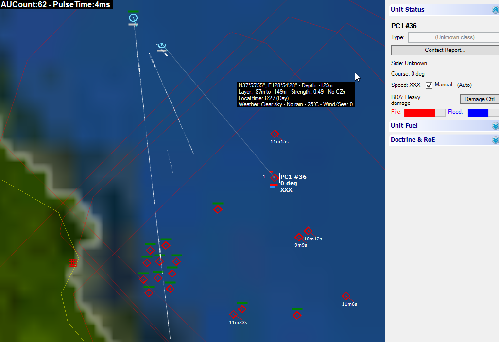
So. Extreme close up. Here's an image fromthe tutorial showing some air action at a zoom level that makes the landscape look reasonable, relief layers (of course!) on. Close enough zoom to make out what's happening?

Image
Attachments
zoom1.jpg
zoom1.jpg (123.18 KiB) Viewed 578 times
Phoenix100
Posts: 2974
Joined: Tue Sep 28, 2010 12:26 pm

RE: The quality of the map/screenshots

Post by Phoenix100 »

Zoom in a bit to distinguish objects

Image

Notice the big tiling line across the bottom and the gorgeous detail.

As I keep saying - it's not how the game looked when people were trying to sell it. Am I doing something wrong?
Attachments
zoom2.jpg
zoom2.jpg (62.57 KiB) Viewed 578 times
Maesphil74
Posts: 93
Joined: Fri Apr 10, 2009 5:51 pm

RE: The quality of the map/screenshots

Post by Maesphil74 »

ORIGINAL: mikmyk

We are not disagreeing with you on what things look like at full zoom but most scenarios don't require it or would be awkward to play that way. What you see in our movies and screenshots is the real deal.

Mike
One of your customers is not agreeing.
(see post 15)
Phil
User avatar
Primarchx
Posts: 1954
Joined: Sun Jan 20, 2013 9:29 pm

RE: The quality of the map/screenshots

Post by Primarchx »

ORIGINAL: phoenix

That's what this guy keeps asking - am I doing something wrong with my settings? I think I know the answer. The levels I'm zooming in to are not extreme at all. Please don't be misleading, Primarchx. They're where you need to be to distinguish different groups of objects (planes, for example). Especially when there's some action.

I posted examples of the Malvinas coastline with relief layers enabled (there's one below in case you missed them) - it's not an issue with relief layers. I would like an answer as to whether that's what it's meant to look like so that if it's not I can figure out what I'm doing wrong.


Image

And if I'm not doing anything wrong - then what on earth is that mess in the image above? It has to be one of the worst graphics I've seen in this type of game. You cannot actually make out where the coastline is.

I don't think I am being misleading and you saying I am is simply your opinion. The image you posted is zoomed in substantially. The issue here, as I see it, is that at high mag the yellow land boundary lines are mixed up with the somewhat blurred land graphic. Yeah, that happens. I have yet to see where it's a big problem and when you're modeling the entire globe for a game, there may be a few inaccuracies involved at the tightest resolutions.

The true arbiter of the land/sea interface is the data block on the mouse tip. Use all the tools at your disposal. I also recall that the Devs have poured substantial time in MANUALLY cleaning up important bits of coastline where their open source data doesn't match up correctly. Can you imagine how tedious and time consuming that is?
Phoenix100
Posts: 2974
Joined: Tue Sep 28, 2010 12:26 pm

RE: The quality of the map/screenshots

Post by Phoenix100 »

deleted


jpkoester1
Posts: 162
Joined: Fri Jun 24, 2005 12:28 pm
Contact:

RE: The quality of the map/screenshots

Post by jpkoester1 »

From http://www.warfaresims.com/?cat=126

Detailed terrain: Command uses as its base terrain reference the Shuttle Radar Topography Mission (SRTM) dataset. This digital terrain model features a base resolution of 3 arc-seconds (~900m/cell at the equator), thus allowing for unprecedented terrain detail benefiting air, naval and land operations alike (LOS now actually matters). (I think this refers to the relief layer.)

AND

Command’s built-in map layers include a global “Blue Marble NG” tileset and a custom relief layer derived from our terrain elevation data. Pretty as they are, their true value lies in their tactical utility: Depth and elevation can be some of your best allies if you understand and use them properly, or your worst enemies if you ignore them. (Blue Marble NG has AFAIK a resultion of 500m and is the tileset used as standard)

Anyways, that's what's in the description of the game, and that's what's delivered (+ the possibility of adding custom overlays).

Surface area of the earth is approximately 510.072.000 square kilometers. At 500m resolution each square kilometer has on average 4 data points, that's about 2 billion data points total. Let's assume you want to take that down to 10m resolution. In that case 1 square kilometer would be 10.000 data points. That would be 5.100.720.000.000 data points or about 5 Terabyte of data (assuming 1 bype per data point and no compression). Even at 100m resulution you end up with ~51 billion data points (Again at 1 byte per data point that's 51 Gigabyte). I am sure you get the idea as to why that's impossible to include...

Cheers,
JP


Edit: someone correct me if my math is totally wrong
Edit2: Of course I know this could be compressed, but even if we assume everyone has large enough harddrives and enough bandwidth for the download it would still be a huge problem to get the hands on the data in the first place. Companies like google spend millions (if not billions) on generating data like that.
"I cna tyep 300 wodrs per minuet"
Phoenix100
Posts: 2974
Joined: Tue Sep 28, 2010 12:26 pm

RE: The quality of the map/screenshots

Post by Phoenix100 »

Substantially or extremely? You said I was using extreme close ups. That was misleading, I feel - and, of course, that's my opinion. Take a look at the two shots above for how such a 'substantially zoomed in level' is useful, under normal circs.

And I can imagine how time consuming it is to have to try to get maps right, yes - the sort of effort that justifies paying 60 quid for a game.

But they would need to do a bit more work, I think. [;)]

But thanks for the answer. In other words - yes, all this is normal. Thanks. For me I would probably have bought this still - to see how the AI worked, at the very least - if I had known in advance that a normal, useful zomm level looked like the images I've posted. I don't care super-much for how the graphics are, if the game play is good. But I would still like to have known. Because I would have thought about it. Because that image of the Malvinas is really appalling.
User avatar
Remmes
Posts: 301
Joined: Fri Feb 11, 2011 8:10 pm
Location: NL

RE: The quality of the map/screenshots

Post by Remmes »

ORIGINAL: Primarchx
I also recall that the Devs have poured substantial time in MANUALLY cleaning up important bits of coastline where their open source data doesn't match up correctly. Can you imagine how tedious and time consuming that is?

What does this fact have to do with the question of OP? IMHO he is at least entitled to an honest answer, especially after coughing up the dough to play the game.

I am really interested in the game, but I have a feeling that you guys are not completely open if the game is critiqued in any form whatsoever.
Phoenix100
Posts: 2974
Joined: Tue Sep 28, 2010 12:26 pm

RE: The quality of the map/screenshots

Post by Phoenix100 »

unprecedented terrain detail , jpkoester, is their interpretation of what the SRTM delivers, in that case.

is this unprecedented terrain detail? I ask you?

Image

if I was told repeatedly, repeatedly given the impression that the graphics contained an unprecedented terrain detail, then got the image above, then I might feel cheated a little, I think. Oh...that is what I'm feeling...
Attachments
crap4.jpg
crap4.jpg (85.5 KiB) Viewed 578 times
Dimitris
Posts: 16021
Joined: Sun Jul 31, 2005 10:29 am
Contact:

RE: The quality of the map/screenshots

Post by Dimitris »

ORIGINAL: Ramses
ORIGINAL: Primarchx
I also recall that the Devs have poured substantial time in MANUALLY cleaning up important bits of coastline where their open source data doesn't match up correctly. Can you imagine how tedious and time consuming that is?

What does this fact have to do with the question of OP? IMHO he is at least entitled to an honest answer, especially after coughing up the dough to play the game.

I am really interested in the game, but I have a feeling that you guys are not completely open if the game is critiqued in any form whatsoever.

Please have a look at this post: http://www.warfaresims.com/?p=1787

And in particular these two screenshots:
http://www.warfaresims.com/WarSimsWP/wp ... Gunzo1.png

These clearly show up the reduced detail at close up.

If our purpose was to mislead customers, as is being claimed here, why exactly would we have published scuh screenshots?
LuckyJim1010
Posts: 260
Joined: Tue Jul 06, 2010 4:08 pm

RE: The quality of the map/screenshots

Post by LuckyJim1010 »

Thought I had wandered into an old MS Flight Sim forum [:)]
User avatar
Primarchx
Posts: 1954
Joined: Sun Jan 20, 2013 9:29 pm

RE: The quality of the map/screenshots

Post by Primarchx »

You guys? I'm not a Dev, just a guy who plays the game. These are my opinions alone.
ORIGINAL: Ramses

ORIGINAL: Primarchx
I also recall that the Devs have poured substantial time in MANUALLY cleaning up important bits of coastline where their open source data doesn't match up correctly. Can you imagine how tedious and time consuming that is?

What does this fact have to do with the question of OP? IMHO he is at least entitled to an honest answer, especially after coughing up the dough to play the game.

I am really interested in the game, but I have a feeling that you guys are not completely open if the game is critiqued in any form whatsoever.
User avatar
Primarchx
Posts: 1954
Joined: Sun Jan 20, 2013 9:29 pm

RE: The quality of the map/screenshots

Post by Primarchx »

Show me another game that has this level of global terrain fidelity?
ORIGINAL: phoenix

unprecedented terrain detail , jpkoester, is their interpretation of what the SRTM delivers, in that case.

is this unprecedented terrain detail? I ask you?

if I was told repeatedly, repeatedly given the impression that the graphics contained an unprecedented terrain detail, then got the image above, then I might feel cheated a little, I think. Oh...that is what I'm feeling...
Phoenix100
Posts: 2974
Joined: Tue Sep 28, 2010 12:26 pm

RE: The quality of the map/screenshots

Post by Phoenix100 »

Ok. Well, that's my last word on that. Thanks for the answers. People can look at the images for themselves - if they're thinking of buying - and judge the level of 'global terrain fidelity'.
jpkoester1
Posts: 162
Joined: Fri Jun 24, 2005 12:28 pm
Contact:

RE: The quality of the map/screenshots

Post by jpkoester1 »

show me one other game that models the whole globe and that offers this kind of detail...

Regards,
JP
"I cna tyep 300 wodrs per minuet"
Maesphil74
Posts: 93
Joined: Fri Apr 10, 2009 5:51 pm

RE: The quality of the map/screenshots

Post by Maesphil74 »

ORIGINAL: jpkoester1

From http://www.warfaresims.com/?cat=126

Detailed terrain: Command uses as its base terrain reference the Shuttle Radar Topography Mission (SRTM) dataset. This digital terrain model features a base resolution of 3 arc-seconds (~900m/cell at the equator), thus allowing for unprecedented terrain detail benefiting air, naval and land operations alike (LOS now actually matters). (I think this refers to the relief layer.)

AND

Command’s built-in map layers include a global “Blue Marble NG” tileset and a custom relief layer derived from our terrain elevation data. Pretty as they are, their true value lies in their tactical utility: Depth and elevation can be some of your best allies if you understand and use them properly, or your worst enemies if you ignore them. (Blue Marble NG has AFAIK a resultion of 500m and is the tileset used as standard)

Anyways, that's what's in the description of the game, and that's what's delivered (+ the possibility of adding custom overlays).

Surface area of the earth is approximately 510.072.000 square kilometers. At 500m resolution each square kilometer has on average 4 data points, that's about 2 billion data points total. Let's assume you want to take that down to 10m resolution. In that case 1 square kilometer would be 10.000 data points. That would be 5.100.720.000.000 data points or about 5 Terabyte of data (assuming 1 bype per data point and no compression). Even at 100m resulution you end up with ~51 billion data points (Again at 1 byte per data point that's 51 Gigabyte). I am sure you get the idea as to why that's impossible to include...

Cheers,
JP


Edit: someone correct me if my math is totally wrong
Edit2: Of course I know this could be compressed, but even if we assume everyone has large enough harddrives and enough bandwidth for the download it would still be a huge problem to get the hands on the data in the first place. Companies like google spend millions (if not billions) on generating data like that.

Even if true that's not an excuse to
1/ only show the nice and pretty screenshots during BETA/advertising. As this is a hardcore oriented game, I imagine a lot of people wouldn't even really notice the bad graphics [:D]
2/To state that the zoomlevel at which bluriness is experienced is not needed during gameplay (although Phoenix is clearly showing you need to play at that level
2/ To even have such bluriness

I was maybe going to buy this over the weekend (depending If I would go to see a saturday evening footballmatch [:'(]) but I'm now really put off by this

sorry...
edit: and no hard feeling btw. I'm just a little dissapointed by this.
Phil
Maesphil74
Posts: 93
Joined: Fri Apr 10, 2009 5:51 pm

RE: The quality of the map/screenshots

Post by Maesphil74 »

ORIGINAL: jpkoester1

show me one other game that models the whole globe and that offers this kind of detail...

Regards,
JP

FS2000 [:D]
Phil
Post Reply

Return to “Command: Modern Operations series”