Road Network in COTA maps

Prepare yourself for a wargaming tour-de-force! Conquest of the Aegean is the next generation of the award-winning and revolutionary Airborne Assault series and it takes brigade to corps-level warfare to a whole new level. Realism and accuracy are the watchwords as this pausable continuous time design allows you to command at any echelon, with smart AI subordinates and an incredibly challenging AI.

Moderator: Arjuna

MarkShot
Posts: 7552
Joined: Sat Mar 29, 2003 6:04 am

RE: Road Network in COTA maps

Post by MarkShot »

ORIGINAL: Arjuna

have changed the road leading from Panteleemon south east across the Castle ridge from a "minor road" to a "track" ( which is now only of benefit to foot units.

I also reduced the move rates for minor roads quite savagely.[:)]

Dave,

You just left my armor without a way to flank and penetrate into the enemy's rear.

This is bad. It is getting to the point where even a beta tester doesn't stand a chance!

See: tm.asp?m=1061598

:)
2021 - Resigned in writing as a 20+ year Matrix Beta and never looked back ...
PyrosLambert
Posts: 50
Joined: Wed Mar 15, 2006 5:30 pm

RE: Road Network in COTA maps

Post by PyrosLambert »

Markshot,

If you read the historical AAR you will conclude that there was no way for any tank group to flank the position of Platamon castle (and this is why the Anzac forces didn't posses any AT guns)...

All Tanks had to pass through the ridge.

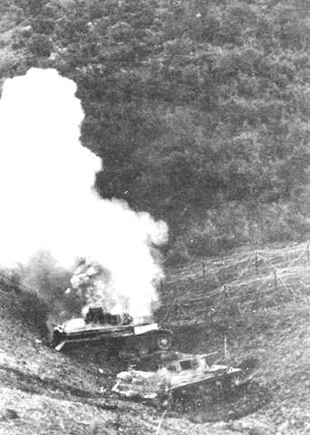
This is an actual Platamon ridge photo (one tank has hit a mine)

Image


Here is one historical AAR of the Platamon battle:
The 2nd Motor Cycle Battalion from 2 Panzer Division, reinforced with engineer, artillery and machine-gun detachments, was leading the way, and by the evening of 14 April had reached the north-east slopes of Mount Olympus. Reconnaissance elements pushed on towards Pandeleimon and had not gone far when they saw soldiers lounging in pits on the forward slopes of a flat-topped ridge. A ruined castle dominated the ridge where it ended abruptly at the sea. Judging by the casual attitude of the soldiers the patrol believed that its advance had not been observed, but soon guns opened up from behind the castle and prevented any movement. Then the guns, evidently attracted by the rest of 2 Motor Cycle Battalion moving up behind the patrol, increased their range and the patrol reported back.

The reconnaissance report, combined with the sound of demolitions that began at dusk and seemed to get farther and farther away, led to the conclusion that the British were occupying only the ridge near the castle and not the hills about it. The commander of 2 Motor Cycle Battalion decided to attack at first light next morning. Meanwhile General Veiel4 of 2 Panzer Division, still mostly to the north of Katerini, had formed two groups to carry out his task. One group, the main body of the division, was to force the Olympus Pass, while the other, the reinforced Motor Cycle Battalion, was to be joined by ⅓ Panzer Regiment (100 tanks), 11/304 Infantry Regiment (one battalion—not to go forward immediately), and two batteries of artillery. The coastal group was to be commanded by Colonel Balck, 3 Panzer Regiment, a hard, strong-willed man who later commanded an Army Group.

During the night of 14-15 April 2 Motor Cycle Battalion formed up to attack the castle, concentrating behind a ridge with the object of attacking the inland flank. Shelling from behind the castle, an irritated diarist says, ‘plagued us, front and rear, right and left… things were damned sour with us for a while’. In the morning, after a brief artillery bombardment, the battalion moved forward, making good progress until it reached the forward slopes of the castle ridge. Here a ‘murderous fire’ broke out, and the leading company suffered heavy casualties, including the company commander. The companies on the west flank found unexpected opposition, and a reconnaissance patrol was sent out to determine 21 Battalion's left flank. This patrol brought back the disconcerting information that the ridge was held as far inland as the village of Pandeleimon.

Colonel Balck arrived to take command at two o'clock in the afternoon. He found that the Motor Cycle Battalion had gone to ground in the tangled undergrowth, boulders and scrub on the forward slopes of castle ridge. Balck gave instructions for the battalion to be withdrawn and reformed. It was then to move out in a wide encircling movement to attack 21 Battalion from above Pandeleimon, while ⅓ Panzer Regiment attacked frontally at the coast. This regiment, commanded by Lieutenant-Colonel Decker,5 had been ordered up from north of Katerini that morning. The roads were crammed with traffic, but the tank battalion rushed up, ‘disregarding all obstacles in its path… a few other vehicles learnt by experience that their mud guards and radiators are not so hard as tanks’. The tanks reached Katerini at two-thirty in the afternoon and Platamon just before six o'clock.

Balck ordered the tanks to attack immediately. The whole of ⅓ Panzer Regiment pushed to within 1200 metres of the castle and deployed to support the unit's light platoon of five Mark II tanks. These advanced on the castle by a narrow cart track, the only means of approach. A terrific fire from rifles, machine guns, and mortars met the tanks, but it was evident that no anti-tank guns protected the castle. The rough country prevented the tanks from closing in, although one tank almost reached a weapon pit. All five of the Mark IIs shed their tracks on boulders and were abandoned under cover of darkness. The regiment suffered no casualties during this attack.

Meanwhile, 2 Motor Cycle Battalion had been attacking C Company 21 Battalion at Pandeleimon. Three of the four companies attacked, as the fourth company had been pinned down in front of the castle until after dark when trying to disengage earlier in the afternoon. One company swung well round over country that was ‘terribly difficult, mountainous and pathless, with slopes of 700 metres to surmount’, and reached Skotina. By some error the two companies attacking frontally made contact before the outflanking company had got into place, and although some positions were siezed at great cost, they were all lost during a sharp counter-attack. The Motor Cycle Battalion called the attack off until dawn next morning, but remained in position close to Pandeleimon. Colonel Balck, after the failure of both tank and infantry attacks, reported to 2 Panzer Division:

The fight for the castle began at nightfall. End not yet in sight. Very fierce resistance, and terrible country.

In the meantime General Boehme had issued a Corps order stating that 2 Panzer Division's main effort was now to be between Olympus and the sea, with Larisa as its objective. The 6th Mountain Division was to assist by capturing the northern foothills of Olympus west of Pandeleimon, and should 2 Panzer Division be further delayed at Platamon, was to move through the mountains to Gonnos to attack the Platamon and Pinios positions from the rear. A special patrol from 6 Mountain Division was to climb Mount Olympus with the German flag—the swastika would pay homage to Zeus.

Elements from 8/800 Brandenburg Regiment, a special unit largely recruited from Germans familiar with foreign countries to undertake intelligence or sabotage tasks, were to outflank the Platamon position by sea in one motor boat and three assault boats. The force was to sail up the Pinios to capture the traffic bridge.6

That night, 15-16 April, 2 Panzer Division sent up reinforcements—1/304 Infantry Regiment and more engineers and artillery. The Germans now had 100 tanks, one battalion of infantry (1026 men), the reinforced Motor Cycle Battalion (more than 1050 men), 1/74 Artillery Regiment (twelve 105-millimetre and four 150-millimetre guns), and other artillery and specialist units. These opposed 21 Battalion, one troop of 25-pounders and one section of engineers, a total of little more than 700 men. So effective had been the fire from the four 25-pounders that 2 Panzer Division estimated that from two to three troops (8-12 guns) were in support of the castle position.

Balck decided to attack again from front and flank. The 2nd Motor Cycle Battalion was to re-attack Pandeleimon, supported this time by 1/304 Infantry Regiment; ⅓ Panzer Regiment, with one company of infantry under command, was to attack frontally; the artillery was to fire a preliminary bombardment and would then give close support. To Balck's annoyance contact was lost during the night between tanks, infantry and motor cyclists, and it was not possible to synchronise the attack. At nine o'clock in the morning of the 16th, following a deception attack at first light, the bombardment started against the castle and surrounding field positions. On the flank the Motor Cycle Battalion attacked with one company moving up behind Pandeleimon, the other three on front and flank. After a very bitter struggle with little success the appearance of 1/304 Infantry Regiment coming up to give support turned the tide, and Pandeleimon was captured with all field positions in the area. Success gave the opportunity to move down the ridge along a good track to roll up the rest of 21 Battalion.

The tanks had been accompanied by engineers to help force a passage, and their story is well told by a participant:

The right-hand company of tanks forced its way forward through scrub and over rocks, and in spite of the steepness of the hillsides got to the top of the ridge. The country was a mass of wire obstacles and swarming with the enemy. In the thick scrub visibility was scarcely a yard from the tanks, and hardly a trace was to be seen of the enemy except an occasional infantryman running back. The tanks pressed forward along a narrow mule path. Many of them shed their tracks on the boulders, or split their track assemblies, and finally the leading troop ran on to mines … and completely blocked the path. A detour was attempted. Two more tanks stuck in a swamp and another was blown up on a mine….

Colonel Macky withdrew his battalion a few minutes before ten o'clock, and Balck signalled to 2 Panzer Division that the castle had been captured at five past ten; he said that his forward units had suffered 25 per cent casualties. The 21st Battalion got clean away, crossed the Pinios River, and by nightfall reached the village of Tempe at the western end of the gorge; its casualties had been light—36 killed, wounded and missing.

The Germans tried to press the pursuit, but immediate advance was impossible as the tanks could not get down the castle ridge. The infantry, badly mauled, needed reorganising. The tunnel through which the railway passed the castle ridge almost at the edge of the sea had been so thoroughly blown that the engineers estimated it would take five days to clear. Actually temporary repairs were effected sooner, but as late as 20 April engineers reported that the tunnel kept falling in and no set time could be given for repairs. One company of tanks tried to get forward along the edge of the sea but found this impossible. In the end the tanks were towed over the ridge, such a slow process that only 25-30 tanks had been got across by eleven o'clock next day.

cheers,
Pyros
User avatar
Arjuna
Posts: 17768
Joined: Mon Mar 31, 2003 11:18 am
Location: Canberra, Australia
Contact:

RE: Road Network in COTA maps

Post by Arjuna »

Pyros,

Well actually standard advance to contact rates for an armoured battalion in WW2 is 16kph across good terrain. The main constraint here is not terrain but formation and other tactical considerations. So if we use that as a bench mark then in 3.5 hours we would assume they would cover 56km. So if they actually covered 35 then we could say that terrain effects for that route amounted to 62.5%. So given what I hagve seen from the maps and your pictures I'd say they did very well indeed.

Avoid the trap of giving terrain too much of an influence. Yes it can be critical, is usually significant, but there are a whole swag of other factors that determine how fast a force moves - eg need for command and control, liklihood of contact with the enemy, the need to clear defiles and potential ambushes.
Dave "Arjuna" O'Connor
www.panthergames.com
User avatar
Crimguy
Posts: 1408
Joined: Fri Aug 15, 2003 6:42 pm
Location: Cave Creek, AZ

RE: Road Network in COTA maps

Post by Crimguy »

Hey Pyros- saw you stirring up the same nest over at SZO's Steel Panthers forum. [:D]

Cheers,
Matt
________________________
www.azcrimes.com
<sig removed because I'm a bandwidth hog>
Golf33
Posts: 701
Joined: Sat Mar 29, 2003 6:54 am
Location: Canberra, Australia

RE: Road Network in COTA maps

Post by Golf33 »

ORIGINAL: PyrosLambert

The main problem with your traffic network is not the quantity of roads but the quality of these roads.
You can't tell the quality of the roads until you've played the game. Once several layers of terrain start to interact, plus the effect of slope, you'll find there is a lot of map area that vehicles can't get to and infantry can only move through slowly.
Greek mountains are extremely rough rocky formations.

The problem with the COTA road network is that most of the mountain roads should be completely inaccessible from vehicles, because this is a historical fact.
Any of the dotted tracks will be inaccessible to vehicles anywhere the ground slope is greater than (IIRC) 30 degrees. This means most of the mountain areas.
It is not a question of slow movement rate but a case of total prohibit of movement.
And this plays a very important role in real (historical) tactics.
This is not news to us. Once you've played the game, or looked at some of the underlying movement maps (I think some older versions got posted up here a while back - I know I did up a few comparison pictures that showed all the inaccessible areas to foot and vehicle) you'll find that it works pretty much exactly as you've described in most scenarios.
You must also take into consideration that from the original 100 tanks only 25 made it to the other way of the ridge. From the rest of these (75) tanks (that failed to be operational) only 6-7 were damaged from mines or artillery hits. The majority of the immobilised tanks were damaged from road conditions (or stuck in mud/swamps).
This also is not news to me. However the game engine has no way of modelling losses due to terrain.
Finally, you should keep in mind that NONE vehicle could bypass the caste ridge and move through the mountain mule-trails.
This is worth checking on the map and it looks like Dave has already dealt with it.
Now, concerning the COTA game... since I haven't played it, I can't judge it![:)]
Correct [:)]
As I told you earlier, the whole issue is about real tactics... The NZ in Platamon didn't posses AT guns because they didn't expect to face a threat of the German Tanks at this unfriendly (for tanks) location...
And when they did face a tank threat, they were forced to pull back rather quickly. Ultimately this led to the near destruction of an Australian brigade group in Tempe Gorge, and the unhinging of the entire Olympus line.

The whole point of COTA for us was to create an environment where real tactics would produce a reasonable result. Once you've actually played the game you'll be better placed to decide whether we've achieved this or not. However, until then, on the basis of a few static screenshots that don't (and can't) show any of the terrain effects, there is absolutely no way you can tell.
ORIGINAL: Golf33
- the game doesn't just use road movement rates as a standard percentage for all roads of a given type; instead it slows movement on the road to take into account the slope as well
- the dashed road type ("track" IIRC) gives no benefit to vehicle movement, instead vehicles travelling in the area of the track use the movement rate of the underlying ground type, modified by the slope
- in some areas it is necessary to have a trafficable road even though none existed historically, because in the historical battle vehicles did move through the area, but in the game maps the scale slope effect would make the area impassable to vehicles without the road

Regards
Steve

It is not your fault, since you ignore the real ground conditions and the possible difficulties for vehicle movement. If you have invested in a small trip to the actual battle locations you would have probably figured out that the inaccessible areas for vehicles should have covered a considerably bigger part of your maps (since this [in conjunction with the bad weather] was the key of several defensive battles, especially in the Greek-Italian Pindus front).
[/quote]
Did you even read the part of my post you quoted? I am sure you don't mean to offend but you write as though you believe you are the only person here who understands the difficulty of movement through Greek terrain, and the only person who has read AARs and seen photos of the area.

I can assure you that I have already seen a good 90% of the photos and quotes you have posted here as they are exactly what I used as my source material in creating these scenarios. They won't be perfect, and once you've played them you will probably be able to improve on them. However, until you've played them, I'd appreciate it if you'd not assume realism was less than my top priority!

You'd be surprised if you knew how much time we spent discussing (and arguing) terrain effects, movement rates, deployment timings and the like in an effort to get as accurate as possible.
But Steve don't worry, because for the 99% of the players, all the above historical details won't matter at all...the only thing that matters is if the game engine runs OK and if the scenarios are well balanced, which I am sure that COTA has very well achieved!
I aimed for historical accuracy first and foremost. There are some what-if and fictional scenarios in which play balance was much more important, but in the historical scenarios I did NOT attempt to balance play by adjusting force levels or terrain effects. Balance in the historical scenarios is achieved (as far as possible) by setting victory conditions in which the historical result is a draw. Players are therefore trying to do better than the historical commanders with the same forces and terrain constraints that the historical commanders faced.

The scenarios will have changed a fair bit since I last worked on them due to the introduction of supply and continued reworking of other aspects of the game engine, but I am sure that the changes will have followed the same principles I used as described above.
Only for real "lovers" of military history this could make a difference.
Which is why it makes a difference to me.

Regards
Steve
Steve Golf33 Long
Image
PyrosLambert
Posts: 50
Joined: Wed Mar 15, 2006 5:30 pm

RE: Road Network in COTA maps

Post by PyrosLambert »

ORIGINAL: Golf33
ORIGINAL: PyrosLambert

It is not your fault, since you ignore the real ground conditions and the possible difficulties for vehicle movement. If you have invested in a small trip to the actual battle locations you would have probably figured out that the inaccessible areas for vehicles should have covered a considerably bigger part of your maps (since this [in conjunction with the bad weather] was the key of several defensive battles, especially in the Greek-Italian Pindus front).
Did you even read the part of my post you quoted? I am sure you don't mean to offend but you write as though you believe you are the only person here who understands the difficulty of movement through Greek terrain, and the only person who has read AARs and seen photos of the area.

I can assure you that I have already seen a good 90% of the photos and quotes you have posted here as they are exactly what I used as my source material in creating these scenarios. They won't be perfect, and once you've played them you will probably be able to improve on them. However, until you've played them, I'd appreciate it if you'd not assume realism was less than my top priority!

You'd be surprised if you knew how much time we spent discussing (and arguing) terrain effects, movement rates, deployment timings and the like in an effort to get as accurate as possible.

Regards
Steve


Steve,

You must realize that there are certain limitations to what a designer / researcher may find on a specific theme and what he can't.

If I wanted to design a campaign of the New Zealand Maori wars, then I am not sure what would be the level of detail of my project.

To make a map with the correct elevation curves is something extremely easy (with the use of all these hi tech satellite map tools).

But this is not enough... because you need to be precise on the landscape conditions of the map, the weather conditions and the road conditions.

And this is not always possible.

For example concerning the Greek-Italian Pindus battle, I am very curious on your level of detail.
More precisely, what were your historical sources and where have you based your research for these battles.
Since these battles involved Greece and Italy, I presume that you should have relied on Greek and Italian translated (and copied) documents (and maps).

To be honest, I haven't read many Italian documents (perhaps, something less than 100 reports), but this isn't the case concerning the Greek material.

I have a collection of the original (ministry of defense) Greek archives related to that period, Greek AARs and Greek maps.
I have also travelled several times to the region and walked the place, visited the WW2 relics and finally spoken to the elders of these villages.

This is how, I stand here today, knowing few things about this battle.

What you call, historical accuracy, or what you think is enough in order to recreate a historical battle is always related with any limitations you have to your resources pool and it is also limited by the business plan of the project.

Since, I am not doing this for money (I do this just for my personal "caprice" and interest), I aim for 99% accuracy.

If you ask me to define 99% accuracy, I would reply you that I am in position to answer in any of the following questions:

What, When, How, Where and Why happened THIS during the "Pindus" campaign.

And this is a fact... not a joke.

For instance, do you know what was the exact number of ammo for all units and all equipments at the beginning of the invasion?
Do you know what kind and where exactly were the fortification works of the Greeks?
Where exactly, how many, what type and what armament had the Bunkers (ammo level?)
What were the weather conditions (each day) on a highly variable weather?
What was the type of the Greek artillery and were exactly was deployed?
What was the AT and AAA capacity of the Greek forces?
What was the movement speed of the Greek and Italian units?
What was the battle plan for both Greek and Italians?
What was the status of the bridges and from which locations the Italians tried to cross the river?
etc... etc...

Steve, I don't really know on how many of the above questions you are in position to give precise answers, or for example if you are in position to describe me what happened the 3rd of November, at 16:00 when 60 Italian Tanks and 80 motorcyclist attacked the Kalpaki hill...

But, I wish to tell you that I don't think that there are too many people on this planet that know better than me what happened at this place (Pindos & Epirus) at this precise period.

I will repeat you that my general impression is that you have made some very accurate (at least concerning elevation curves and topology) maps and that I have the feeling (and I wish) that the game will be of very high standards. [:D]

cheers,
Pyros

p.s I already mentioned (several times) in my posts that this game is by far the most accurate game concerning this campaign.
p.s I won't make any further constructive criticism on speculations concerning elements of this fine game and I respect all the hard work that you people did for this game. [;)]
PyrosLambert
Posts: 50
Joined: Wed Mar 15, 2006 5:30 pm

RE: Road Network in COTA maps

Post by PyrosLambert »

If I find some free time, I will post here some information concerning the details of the Pindus campaign.

One of the biggest mistakes of the Italian HQ was the fact that it didn't took seriously the defensive earth-work and fortifications that the Greek HQ has constructed in the Albanian front during the period 1935-1940.

In order to present you a point of reference for these fortifications, I would mention that in the sector of KALAMAS-ELEAS (Kalpaki), there were:

66,000 meters of trenches (depth 1.30 meters)
15 MG Pillbox with durability to a 105 mm direct shot
269 MG Pillbox with durability to a 75 mm direct shot
22 AT prepared positions (not covered) of 37 and 13,2.
5,700 meters of barbed-wire of 3-5 depth

Furthermore in the Kalpaki area there were constructed:

20 double MG Pillbox graved inside the rock
16 artillery positions (emplacements) with 2-3 underground ammo storehouses
30 covered positions -shelters for the artillery personnel
110 covered positions -shelters (capacity of 30 men) for infantry troops
10 reinforced observatory post

cheers,
Pyros
User avatar
Tactics
Posts: 324
Joined: Sun Oct 27, 2002 11:52 pm
Location: USA
Contact:

RE: Road Network in COTA maps

Post by Tactics »

Image

Image
User avatar
Crimguy
Posts: 1408
Joined: Fri Aug 15, 2003 6:42 pm
Location: Cave Creek, AZ

RE: Road Network in COTA maps

Post by Crimguy »

It appears to be a subject near and dear to Pyros.
________________________
www.azcrimes.com
<sig removed because I'm a bandwidth hog>
Golf33
Posts: 701
Joined: Sat Mar 29, 2003 6:54 am
Location: Canberra, Australia

RE: Road Network in COTA maps

Post by Golf33 »

Pyros,

The Pindos campaign was one area where I was not totally happy with the amount of information we were able to get hold of. As a result there is a bit more approximation than usual in orders of battle for both sides. Our focus was also a bit more on the 1941 battles involving Greek and Commonwealth forces against the Germans. I hope that once COTA comes out, you will apply the research you have conducted to develop some custom maps and scenarios to really do this campaign justice.

One thing to be aware of is that we are not able to use satellite data to develop maps for COTA. We develop our maps by sourcing and scanning printed topographic maps. These are then traced in the MapMaker, but it's not as simple as it sounds - there is usually quite a bit of interpretation required deciding what to represent and what to leave out, working out what roads marked on the map are real roads and what are just goat tracks.

We try and get 1:50 000 scale source maps if we can (this contains enough detail and is still manageable, 1:25 000 is actually a bit too detailed for the game scale and is too big when scanned). For Pindos, we weren't able to locate useable large-scale maps so were limited to 1:250 000. If you have more detailed maps available to you, you might be able to generate better maps.

Regards
Steve
Steve Golf33 Long
Image
Post Reply

Return to “Conquest of the Aegean”